Explainer
GPS Jamming and Spoofing Explained: How Maps Detect It
Jamming drowns out satellite navigation signals; spoofing replaces them with false ones. Public maps cannot measure either directly, so it helps to know what each map is really showing.
Key takeaways
- Jamming blocks GNSS reception; spoofing feeds receivers counterfeit signals so they compute a wrong position or time.
- Aviation regulators treat spoofing as the greater risk, because it is harder for crews to recognize than jamming.
- Many public jamming maps infer interference from aircraft ADS-B quality fields (NIC or NACp), aggregated over hours.
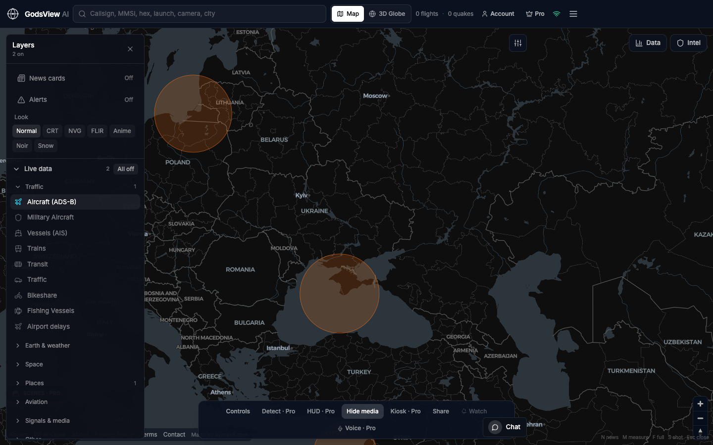
- The GodsView GPS jamming layer shows known interference zones and aviation SIGMETs that mention GPS or GNSS interference; it does not compute NIC or NACp.
- In the United States, operating, marketing or selling jammers is illegal for non-federal users, according to the FCC.
GPS jamming is radio interference that stops a receiver from picking up satellite navigation signals. GPS spoofing is the transmission of fake satellite-like signals that trick a receiver into calculating the wrong position or time. Jamming makes navigation fail; spoofing makes it lie, which is why aviation regulators consider spoofing the more dangerous of the two.
Neither can be seen directly on a public map. What you see on a "GPS jamming map" is an inference. Some maps infer interference from the navigation quality that aircraft broadcast over ADS-B. Others, including the GodsView AI layer, plot known interference zones and official aviation notices. Each approach answers a slightly different question, and knowing which one you are looking at changes how you should read it.
This guide covers how jamming and spoofing work, why satellite signals are easy to disrupt, how maps infer interference, what official notices say, where interference is most reported, how it affects aircraft, what the law says in the US, and what these maps cannot tell you.
What is GPS jamming?
The FAA's GNSS Interference Resource Guide defines jamming as emissions that do not mimic GNSS signals but interfere with a civil receiver's ability to acquire and track them. In plain terms, a jammer transmits noise or another signal on or near the navigation frequencies, overpowering the very weak signals arriving from orbit.
The result is denial of service. Receivers lose their position fix, or fall back to a less accurate mode. For aircraft, that can mean the loss of GPS-based navigation and of any system that depends on it.
GPS is one GNSS (global navigation satellite system) among several. The FAA guide notes that Galileo, BeiDou and GLONASS are others, and interference often affects more than one system at once. This article uses "GPS jamming" because that is how most people search for it, but the issue is broader.
What is GPS spoofing?
Spoofing is the transmission of false signals that imitate genuine GNSS signals. According to the FAA guide, a spoofed signal can look like a valid signal with a correct code structure but altered location or timing data. When it is stronger than the authentic signal, a receiver may accept it and compute a false position.
The FAA guide adds two points that matter for anyone reading a map. Spoofing effects can start instantly or with a delay, and they can persist after the aircraft leaves the area, for example in inertial systems or flight management systems that absorbed the false data. It also notes that jamming is often used as a first step to make a spoofing attack work.
Jamming vs spoofing: the short answer
| Jamming | Spoofing | |
|---|---|---|
| What it does | Blocks or overwhelms real signals | Replaces real signals with counterfeit ones |
| Receiver result | No fix or degraded fix | A confident but wrong position or time |
| How obvious it is | Usually noticed quickly | Can be hard to detect |
| Typical map signature | Many aircraft reporting low navigation accuracy | Implausible tracks, jumps, or aircraft appearing in the wrong place |
| Lingering effects | Usually end when the signal is gone | Can persist after leaving the area |
The EASA Safety Information Bulletin 2022-02R4, issued on July 3, 2026, states that there are no specific flight-crew alerts telling crews which kind of interference they face, that jamming effects are typically immediate and noticeable, and that spoofing may be harder and slower to detect, which poses more safety risk.
Why are GNSS signals so easy to interfere with?
Navigation signals arrive at the ground very weak. The FAA guide puts it simply: GNSS signals are vulnerable to interference because of their extremely low power. A transmitter close to the receiver can be stronger than the real signal.
The civil frequencies are public. According to a GPS.gov modernization fact sheet, GPS broadcasts on L1 at 1575.42 MHz, L2 at 1227.6 MHz and L5 at 1176.45 MHz, and the long-standing civil C/A signal is on L1. Not all interference is deliberate, either. The FAA guide lists ionospheric effects, solar activity and GNSS repeaters among other sources.
The FAA guide also lists real-world uses that cause interference: militaries near borders and sensitive sites, protection against drones at large events, counter-drone systems used by authorities, and commercial drivers trying to hide their location.
How do GPS jamming maps detect interference from ADS-B?
Most public jamming maps rely on aircraft. Modern aircraft broadcast their position over ADS-B (see how ADS-B flight tracking works), and each position report carries quality indicators. Two matter here:
- NIC (Navigation Integrity Category) gives a containment radius: how sure the system is that the true position lies within a given distance of the reported one.
- NACp (Navigation Accuracy Category for Position) gives an estimate of position accuracy.
US rules set minimums for these values. Under 14 CFR 91.227, aircraft ADS-B Out must report a NACp of less than 0.05 nautical miles and a NIC of less than 0.2 nautical miles. When interference degrades the navigation source, these values drop. When many aircraft in the same area report low values at the same time, interference is the likely explanation.
Two well-known examples
GPSJam (gpsjam.org) aggregates ADS-B data from the airplanes.live and ADS-B Exchange receiver networks into hexagonal cells over 24 hours. Its FAQ describes cells as green when more than 98 percent of aircraft report good navigation accuracy, yellow for 2 to 10 percent low and red for more than 10 percent low, updated every 24 hours shortly after midnight UTC. The FAQ is clear that the method cannot tell jamming from spoofing or other causes, and that areas without aircraft show no data.
Flightradar24 publishes a GPS jamming map built from the NIC values in ADS-B messages, according to its launch post. It shows interference levels from low to high and is updated every six hours, with six-hour and 24-hour views.
Both are useful and transparent about their methods. They share the same constraint: they see interference only where suitably equipped aircraft are flying and being received.
How do official notices describe GPS interference?
The second source of information is aviation authorities. In the United States, the FAA guide explains that the government regularly runs GPS tests, training and exercises that interfere with GPS. These are geographically limited, scheduled and published through NOTAMs (Notices to Airmen) and FAA public notices, and pilots are told to check NOTAMs for their route. Pilots are also encouraged to report interference to ATC and through the FAA's "Report a GPS Anomaly" website.
In Europe, the EASA bulletin asks national authorities to verify that NOTAMs are issued describing affected areas, and EASA publishes a list of affected flight information regions on its website. Aviation SIGMETs, in-flight hazard advisories, can also carry text about GPS or GNSS interference, which is why the GodsView layer watches them.
Notices have different strengths from ADS-B inference. They are authoritative and sometimes give planned times and areas, but they are written by people, can be broad, and may not appear for short or unannounced events.
What the GodsView GPS jamming layer actually shows
To be precise about our own map: the GodsView GPS jamming layer combines known interference zones with aviation SIGMETs that mention GPS or GNSS interference, and refreshes about every five minutes.
It does not use gpsjam.org data, and it does not calculate NIC or NACp from aircraft. So a highlighted area on the GodsView layer means "this is a documented interference zone" or "an aviation authority has issued an advisory mentioning GPS or GNSS interference here". It does not mean "aircraft in this hexagon reported degraded accuracy in the last few hours".
| Approach | What it measures | Strength | Limitation |
|---|---|---|---|
| ADS-B NIC/NACp maps (GPSJam, Flightradar24) | Share of aircraft reporting degraded navigation quality | Shows actual effects on aircraft | No aircraft, no data; cannot separate jamming from spoofing |
| Official notices (NOTAMs, SIGMETs) | What authorities have published | Authoritative, sometimes forward-looking | Can be broad, delayed or absent |
| GodsView GPS jamming layer | Known interference zones plus SIGMETs mentioning GPS/GNSS interference | Fast to scan alongside live flights | Not a measurement of aircraft accuracy |
The layer is most useful next to live traffic. Open the GPS jamming map, add the live flight tracker layer, and you can see which routes pass through documented zones. With GodsView Pro you can also add military aircraft from the adsb.lol military feed and FAA charts, SIGMETs and NOTAM layers. Every source is listed on the methodology page.
Where is GPS interference most common?
Reported interference clusters around conflict and geopolitical risk zones. The EASA bulletin names the south and eastern Mediterranean, the Black Sea, the Middle East, the Baltic Sea and the Arctic area. The FAA guide's appendix lists areas of major spoofing including the Eastern Mediterranean, the Black Sea, Russia and the Baltic region, the India and Pakistan border, Iraq and Iran, North and South Korea, and the area around Beijing.
The FAA guide also notes that interference near conflict zones can extend hundreds of miles beyond the immediate area, and that spoofing devices may be on military vehicles, fixed sites on land or vessels at sea. For regional context, the Ukraine, Middle East and Korea live maps show flights and events in some of these areas, and our guide to how live conflict maps work explains how to read them carefully.
How does GPS jamming and spoofing affect aircraft?
Interference adds risk and workload for both crews and air traffic controllers. The EASA bulletin lists examples of what degraded GNSS can cause, including:
- Loss of, or misleading, terrain warnings, including spurious "pull up" alerts that in some cases led to steep, uncoordinated climbs.
- Corrupted ADS-B surveillance, so the position other aircraft and controllers see is wrong.
- Wrong aircraft position, GNSS altitude or ground speed on displays and electronic flight bags.
- Wrong time or date in systems that depend on it, such as clocks and data-link messages.
- Inability to fly GNSS-based RNAV or RNP procedures, sometimes leading to re-routing or diversions.
EASA recommends keeping conventional navigation aids such as ILS, DME and VOR available as backups. The FAA guide adds that after spoofing, receivers may need a reset and that inertial and flight management systems can carry the error forward.
For flight trackers, this matters in a specific way: a spoofed aircraft can appear on a map in a place it never was. If you see an aircraft circling in an impossible pattern or jumping across a region with known interference, consider spoofing before drawing conclusions. Our military aircraft tracking guide explains why some aircraft in these regions broadcast ADS-B and others do not.
Is GPS jamming legal?
In the United States, the FCC states that federal law prohibits operating, marketing or selling any type of jamming equipment, including devices that interfere with GPS, with use limited to certain authorized federal agencies. The FCC warns that violations can bring substantial fines, seizure of equipment and criminal penalties. Other countries have their own rules, and the EASA bulletin asks European authorities to act against the sale and use of unauthorized transmitters. This is general information, not legal advice.
What GPS jamming maps cannot tell you
Every interference map has blind spots, including ours:
- No aircraft, no ADS-B data. Maps built from NIC or NACp cannot see interference over empty sea, closed airspace or regions without receivers.
- They cannot always tell jamming from spoofing. GPSJam says so directly, and EASA notes there are no specific crew alerts that say which one is happening.
- Low accuracy has other causes. The FAA lists ionospheric effects, solar activity and GNSS repeaters among sources of interference, alongside deliberate jamming and spoofing.
- Notices lag reality. Official zones and SIGMETs depend on someone filing them.
- Ground users are not measured. These maps reflect aviation data, not phones, cars or ships on the ground.
- They are not operational tools. Pilots should rely on NOTAMs, official briefings and ATC.
Satellite navigation is one part of a wider space system; our guide to how satellite tracking works explains how those satellites are followed from the ground.
The short version
Jamming drowns out navigation signals; spoofing replaces them with false ones and is harder to spot. Public maps infer interference either from aircraft ADS-B quality fields or from official zones and notices. The GodsView layer belongs to the second group: known interference zones plus aviation SIGMETs that mention GPS or GNSS interference, refreshed about every five minutes. Use ADS-B-based maps and official notices together for the fullest picture, and leave flight decisions to official sources.
Frequently asked questions
What is the difference between GPS jamming and spoofing?
Jamming transmits interference that stops a receiver from tracking satellite signals, so navigation degrades or fails. Spoofing transmits counterfeit signals that imitate real ones, so the receiver confidently computes a wrong position or time. EASA notes that jamming is usually noticed quickly, while spoofing can be harder to detect and therefore poses more safety risk for aircraft.
How do GPS jamming maps work?
Many maps, such as GPSJam and the Flightradar24 GPS jamming map, use the navigation quality values that aircraft broadcast over ADS-B, called NIC and NACp. When many aircraft in one area report degraded values over a few hours, the map colors that area. Other maps plot official interference zones and aviation notices instead. They show inferred interference, not a direct measurement of the signal.
Does the GodsView GPS jamming map use ADS-B NIC data?
No. The GodsView GPS jamming layer shows known interference zones plus aviation SIGMETs that mention GPS or GNSS interference, refreshed about every five minutes. It does not use gpsjam.org data and does not compute NIC or NACp from aircraft. For an ADS-B-based view, use a NIC-based map alongside it. Sources are listed on the methodology page.
Where is GPS jamming happening right now?
Interference is reported most often near conflict and geopolitical risk zones. EASA lists the south and eastern Mediterranean, the Black Sea, the Middle East, the Baltic Sea and the Arctic area, and the FAA lists further hotspots such as the India and Pakistan border and the Korean peninsula. Check the GPS jamming map and current NOTAMs for the latest picture.
Is it illegal to use a GPS jammer?
In the United States, yes for non-federal users. The FCC says federal law prohibits operating, marketing or selling jamming equipment, including GPS jammers, and violations can bring fines, equipment seizure and criminal penalties. Other countries have their own rules. This is general information, not legal advice.
Can GPS spoofing make a plane appear in the wrong place on a flight tracker?
Yes. ADS-B positions come from the aircraft's own navigation system, so if it has been spoofed, the broadcast position can be wrong. EASA lists corrupted ADS-B surveillance among reported effects. Impossible circles, sudden jumps or tracks far from a plausible route in a known interference area are signs to treat the position with caution.
Sources
- FAA — GNSS Interference Resource Guide (version 1.1, 2026)
- EASA — Safety Information Bulletin 2022-02R4 (issued July 3, 2026)
- 14 CFR 91.227 — ADS-B Out equipment performance requirements
- GPS.gov — GPS modernization fact sheet (signal frequencies)
- FCC — Jammer enforcement
- GPSJam — FAQ and methodology
- Flightradar24 — GPS jamming map
- Flightradar24 — Launch post for the GPS jamming map