How-to
How to Track Helicopters Live (and Why Some Never Show)
Helicopters fly low, start and stop in odd places, and are often missing from flight maps. Here is how to find the ones that do broadcast, read what they are and who flies them, and understand the gaps.
Key takeaways
- Most helicopter trackers use the same ADS-B data as flight trackers. A helicopter shows up when it broadcasts and a receiver is close enough to hear it.
- Low altitude is the biggest problem: radio needs line of sight, so a helicopter at a few hundred feet often drops out between receivers.
- US rules require ADS-B Out in busy airspace, including within 30 nautical miles of major airports, but not in much of the low airspace where helicopters work in rural areas.
- The ICAO type code tells you the model, and the registration, looked up in a national register, usually tells you the owner.
- The flight path is a clue to the job: tight orbits, straight runs along a line, and short hops to a hospital each look different on the map.
To track a helicopter live, open a live flight map that marks helicopters, find it near where you hear it, and click it to see its registration, type, altitude and track. On GodsView, every city page on planes over has a helicopter section, and What's overhead lists anything within 60 km of you. If the helicopter broadcasts ADS-B and a receiver can hear it, it will be there.
That second condition is the catch. Helicopters are much harder to track than airliners, and a large share of the ones you hear never show on any public map. This guide explains why, how to make the most of the ones that do appear, and how to work out the type and operator from what the tracker shows.
If you are standing outside right now wondering why one is circling over your street, start with why is a helicopter circling. This page is the wider version: how helicopter tracking works and how to get better at it.
See helicopters over your city
How a helicopter tracker works
There is no separate helicopter network. Helicopter trackers read the same ADS-B broadcasts as any live flight tracker, then pick out the rotorcraft.
There are two ways to tell a helicopter apart from a plane in the data:
- The emitter category. Each ADS-B identification message carries a category field, and one of its values means rotorcraft (The 1090 Megahertz Riddle). Not every aircraft fills it in correctly.
- The type code. Trackers look the aircraft's hex code up in a database to get its ICAO type designator, such as EC35 or R44, and check it against a list of helicopter types.
GodsView's city pages use both. They flag an aircraft as a helicopter when its type code is on a list of 76 helicopter designators, or when the category says rotorcraft and no type is known. That covers common civil types like the Robinson R44 (R44), Airbus EC135 (EC35) and EC145 (EC45), Leonardo AW139 (A139) and Bell 407 (B407), as well as military types like the H-60 Black Hawk family and the V-22 Osprey tiltrotor.
Why helicopters are harder to track than planes
An airliner at 35,000 ft can be heard by receivers hundreds of kilometres away. A helicopter at 500 ft can't. Four things work against helicopter tracking.
| Problem | Why it happens | What you see |
|---|---|---|
| Low altitude | ADS-B is a line-of-sight radio signal; hills, buildings and the curve of the Earth block it | The helicopter flickers in and out, or vanishes when it descends |
| Not required to broadcast | ADS-B Out rules cover busy and high airspace, not all low airspace | No dot at all, even in good coverage |
| Allowed to switch off | Sensitive government missions can be authorized to stop transmitting | Police or military helicopters missing while others show |
| Identity hidden | Privacy programs filter or mask the owner | A position and type, but no name |
The first one is physics. Receivers are mostly volunteers' rooftop antennas, so coverage near the ground depends on how many there are and where. In a dense city, a helicopter over the river may be visible while one landing behind a ridge drops out. GodsView's city pages say so in their coverage note: coverage within 60 km of a big city is usually good above a few thousand feet, and "low helicopters can drop out between receivers."
Which helicopters have to broadcast ADS-B?
This is where most confusion comes from. In the United States, the rule is 14 CFR 91.225. Since January 1, 2020, unless air traffic control authorizes otherwise, an aircraft needs ADS-B Out in:
- Class A airspace;
- Class B and Class C airspace around busy airports;
- within 30 nautical miles of the airports listed in the rule's appendix, from the surface up to 10,000 ft MSL;
- above the ceiling and within the lateral limits of Class B or C airspace, up to 10,000 ft;
- Class E airspace in the 48 contiguous states at and above 10,000 ft MSL, excluding the airspace at and below 2,500 ft above the surface;
- Class E airspace at and above 3,000 ft over the Gulf of Mexico within 12 nautical miles of the US coast.
Read that list with a helicopter in mind. Inside the 30-mile ring around a major airport, a helicopter generally needs ADS-B Out, even at low level. Outside those rings, below 10,000 ft and outside Class B and C, it doesn't. A medical or utility helicopter working between small towns can fly a whole shift without ever entering airspace that requires it.
Two more parts of the rule matter:
- Sensitive missions. Section 91.225(f) lets the FAA authorize an aircraft on a national defense, homeland security, intelligence or law enforcement mission to stop transmitting when broadcasting would compromise the mission's security or pose a safety risk. That is why a police helicopter can be missing while a news helicopter over the same scene is visible.
- No electrical system. Aircraft certificated without an engine-driven electrical system are exempt from much of the rule. That mostly affects gliders and balloons rather than helicopters.
Outside the US, rules differ. The European mandate covered aircraft with a maximum take-off mass above 5,700 kg or a maximum cruising speed above 250 knots (SKYbrary), which leaves out most light and medium helicopters. Many still carry a Mode S transponder, and some trackers can place those by multilateration when enough receivers hear them.
How to find a helicopter live, step by step
- Start near you. Open What's overhead and share your location. It lists every broadcasting aircraft within 60 km, closest first, with the compass direction and how high above the horizon to look. A helicopter will usually be near the top with a low altitude and a slow speed.
- Check your city page. Open planes over and pick your city, for example London or New York City. The summary counts helicopters within 60 km, and the section Helicopters, military and low planes lists them with type, distance, direction and altitude.
- Look for the circling flag. The same page checks low aircraft once a minute over the last 20 minutes and marks any that made a full turn or stayed within a few kilometres of one spot.
- Open it on the map. Click through to the globe or the live flight tracker to see the track and the data panel. The search box also accepts aircraft models: typing "helicopter", or a type code such as EC35, lists broadcasting aircraft that match.
- Note the identifiers. Write down the registration, hex code and type before it lands. Helicopters often switch off soon after landing, and the dot disappears.
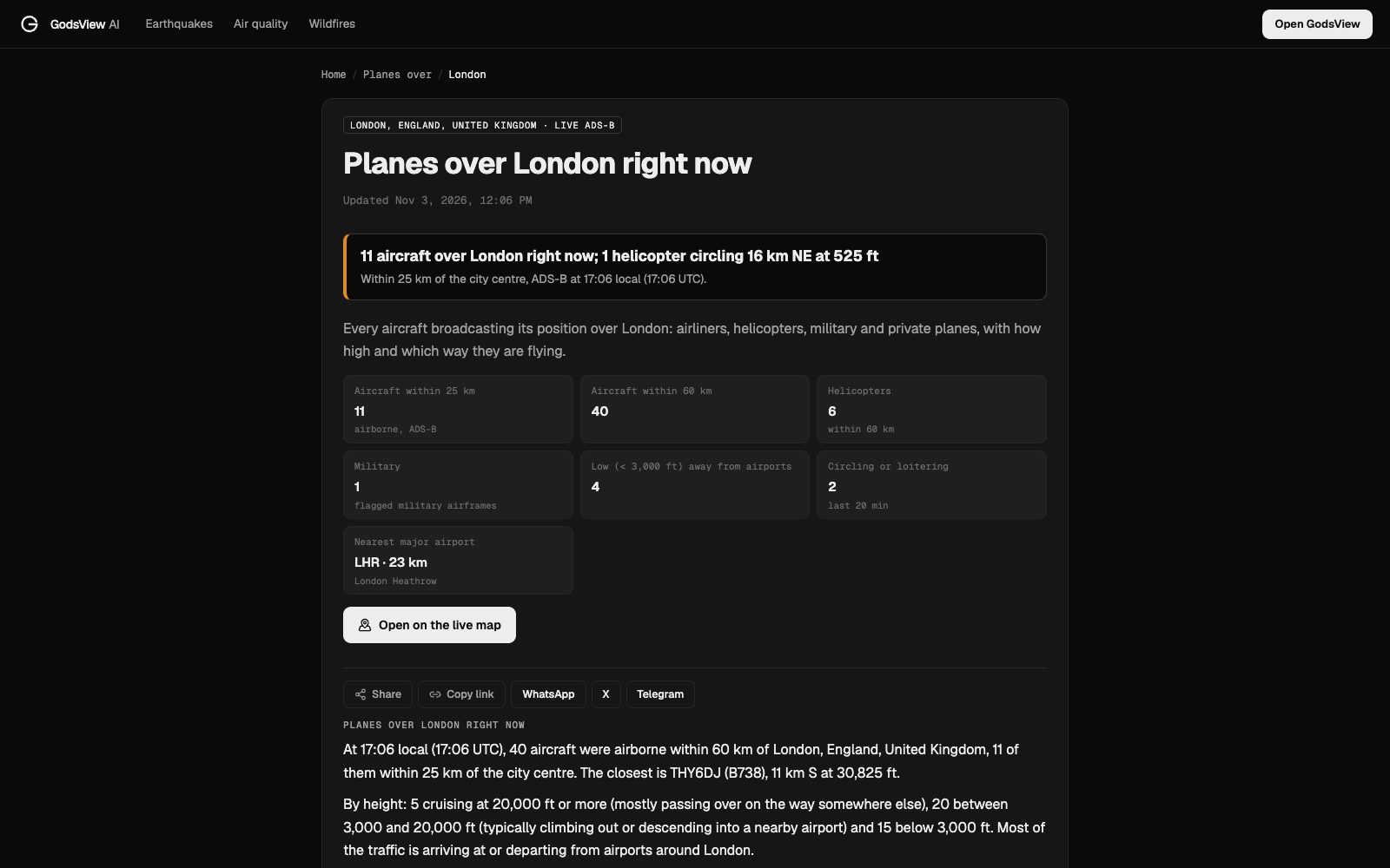
When nothing is listed but you can clearly hear rotors, the page tells you so: it may be a police or military helicopter that does not transmit ADS-B, or one too low for the receivers to hear.
How to identify the type and operator
A helicopter on a tracker usually comes with three identifiers. Each tells you something different.
| Identifier | Example | What it tells you | Where to look it up |
|---|---|---|---|
| ICAO type designator | EC35, A139, R44, B407 | The make and model | Search the code; it is a standard ICAO designator |
| Registration | An N-number in the US, G- in the UK | The specific airframe and its registered owner | The national aircraft register |
| Callsign | MEDEVAC flights, operator callsigns, or just the registration | Who is flying it and sometimes why | Compare with the registration |
Step one: the model. The type code tells you size and role at a glance. A two-seat piston trainer, a twin-engine air ambulance and a military transport look very different on a type lookup, even when they are all small dots on a map.
Step two: the owner. Look the registration up in the national register. For US aircraft, the FAA registry shows the manufacturer, model, aircraft type (such as rotorcraft), the Mode S hex code and the registered owner's name and address. In the UK, the CAA's G-INFO register does the same job for G- registrations.
Be careful with that owner field. The registered owner is often a leasing company, a bank trust or an LLC rather than the police force, hospital or TV station that actually flies the helicopter. The paint scheme, the callsign and the places it lands are often better clues than the owner's name.
Step three: the callsign. Some helicopters broadcast their registration as the callsign. Others use an operator callsign. US air ambulance flights that need priority use the word MEDEVAC in front of their callsign on the radio, and the FAA's examples include a flight identified as MDSTR1 being called "MEDEVAC Medstar One" (FAA AIM 4-2-4). US Army helicopters are identified by "Army Copter" and the last five digits of the serial number, per the controllers' handbook (FAA JO 7110.65, 2-4-20). On a tracker, those usually show as a short coded callsign rather than the spoken words. Our guide to what a flight call sign is goes through the formats.
Police, medical and news helicopters
These are the helicopters people most often want to track, and each has its own pattern.
Police helicopters. They are the most likely to be missing. Law enforcement missions are one of the categories that can be authorized to stop transmitting under the US rule, and the FAA's LADD page has a separate route for data-limiting requests from government, military and law enforcement aircraft. When a police helicopter does show, it often holds a steady orbit over one spot while the crew watches the ground.
Air ambulances. Medical helicopters usually broadcast. Their flight path tells the story: a fast, direct line from a base to a scene, a short time on the ground, then a direct line to a hospital with a helipad. They may also orbit for a few minutes while a landing site is cleared. The MEDEVAC prefix on the radio is reserved for urgent medical flights, according to the FAA.
News helicopters. They have no mission-security reason to switch off, so they usually show. They tend to arrive at a scene after it starts and stay for a long time, circling wider than a police helicopter so the camera can show the whole picture.
Tours, transport and work. Over some cities, sightseeing helicopters fly regular routes. In New York, the Hudson River and East River exclusions are low corridors below the city's Class B airspace with their own rules: pilots must self-announce, keep to 140 knots or less and, over the Hudson, keep to the west shore southbound and the east shore northbound. The FAA's definitions list sightseeing, news gathering and law enforcement among the local operations there (14 CFR 93 Subpart W).
Reading the flight path: circling, lines and hops
Once you have found a helicopter, its track is often more useful than any label.
| Pattern on the map | What it often means | What else to check |
|---|---|---|
| Tight orbit over one spot | Watching something: a police search, a fire, an accident | Local police or news channels |
| Wide, slow circle | Filming from a distance, often news | Local TV live streams |
| Straight runs along a line, back and forth | Inspecting power lines or pipelines, or a survey grid | Utility notices, the route of the line |
| Direct line, landing, direct line out | Medical transfer or passenger transport | Hospitals and helipads along the route |
| Short circuits at an airfield | Training | Flight schools at the field |
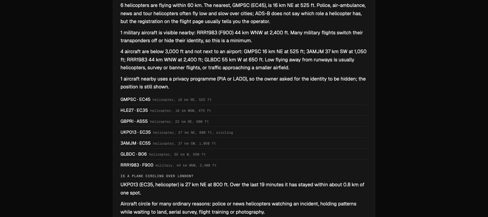
GodsView's circling flag is designed for the first two. It checks low aircraft near each city once a minute and marks a helicopter that has made a full turn or stayed within a few kilometres of one spot during the last 20 minutes. On the London page in the screenshot above, an EC35 had stayed within about 0.8 km of one spot for 19 minutes at 800 ft.
The same logic applies to planes, but with different reasons. Holding patterns and training circuits are explained in why is a plane circling.

Tips for better helicopter tracking
- Check early. Helicopters often switch off their transponders soon after landing. Look while it is still in the air.
- Use the city page, not the whole map. On a world map, a helicopter is a tiny dot among thousands of airliners. The city page lists helicopters on their own.
- Expect gaps at low level. If a helicopter flickers in and out, it is probably flying under the receivers' line of sight, not switching off.
- Read "none visible" carefully. No helicopter on the map is not proof that none is flying. Police and military helicopters are the usual gaps.
- Separate what from why. The map tells you what the helicopter is and where it is. For why it is there, ask the operator or check local news.
What's flying over me right now?
Military helicopters
Military helicopters are the hardest of all. Many fly without broadcasting, and some trackers filter military aircraft entirely. Community networks show the ones that do broadcast, and GodsView flags military airframes on its city pages and on the military flight tracker, which is a GodsView Plus layer.
When a military helicopter does show, its callsign often follows the service formats in the FAA handbook, and its type code, such as H60 or H47, gives away the model. Our military aircraft tracking explainer covers what is and isn't visible, and why one tracker may show an aircraft that another hides.
Frequently asked questions
Is there a live helicopter tracker?
Yes. Any ADS-B flight map shows helicopters that broadcast. GodsView city pages on planes over list helicopters separately with type, altitude and distance, and What's overhead lists everything within 60 km of you.
Why can I hear a helicopter but not see it on the tracker?
It may be flying too low for nearby receivers, it may not be required to carry ADS-B Out where it is flying, it may be a police or military aircraft authorized not to transmit, or its identity may be filtered by a privacy program.
Do helicopters have to use ADS-B?
In the US, they need ADS-B Out in the same airspace as planes: Class A, B and C, within 30 nautical miles of major airports up to 10,000 ft, and in most Class E airspace at and above 10,000 ft. Much low-level airspace away from big airports has no requirement.
How can I tell who owns a helicopter?
Look up its registration in the national register, such as the FAA registry for N-numbers or G-INFO for UK aircraft. The registered owner is sometimes a leasing company or trust, so check the callsign and where it lands too.
Can I track police helicopters?
Sometimes. Some police helicopters broadcast ADS-B and appear normally. Others fly with transmissions authorized off for law enforcement missions, or use privacy programs, and do not appear on public trackers.
What does it mean if a helicopter is circling on the tracker?
Usually that it is watching something on the ground: a police search, an incident, or a news story. See why is a helicopter circling for the common reasons and who to ask.
Sources
- 14 CFR 91.225: ADS-B Out equipment and use
- 14 CFR Part 93 Subpart W: New York Hudson River and East River Exclusion SFRA
- FAA Aeronautical Information Manual 4-2-4: Aircraft call signs (MEDEVAC)
- FAA Order JO 7110.65, 2-4-20: Aircraft identification
- FAA aircraft registry inquiry
- UK CAA: G-INFO aircraft register search
- Junzi Sun, The 1090 Megahertz Riddle: ADS-B aircraft identification and category
- SKYbrary: Regulation 1028/2014 (EU ADS-B Out thresholds)
Facts checked on against each provider's own site.