Explainer
Is God's Eye Real? The Technology Behind the Idea
In Furious 7, God's Eye finds anyone on Earth in seconds. Nothing public works like that. Here is what is real, what is fiction, and where open maps such as GodsView fit.
Key takeaways
- God's Eye is a fictional program from the 2015 film Furious 7. No single public or commercial system can do what it does on screen.
- Pieces of the idea are real: aircraft and ships broadcast their positions, satellites photograph the Earth, and many cameras are online. But each piece has hard limits.
- Free satellite imagery from Sentinel-2 and Landsat resolves 10 to 30 meters per pixel, and commercial satellites around 30 cm. None of them can identify a face from orbit.
- In the US, the Supreme Court ruled in 2018 that police generally need a warrant to get a person's historical cell phone location records.
- GodsView shows only public data: aircraft, ships, satellite orbits, hazards, news and public cameras. It is not a surveillance tool and cannot track people.
No, God's Eye is not real. It is a fictional surveillance program from the 2015 film Furious 7, shown as software that can find any person on Earth by tapping into the world's phones and cameras. No public or commercial system works that way. Some of the ingredients are real, though: planes and ships broadcast their positions, satellites photograph the Earth every day, and many cameras stream to the internet. The gap between those pieces and the movie is large, and this guide walks through it.
We also cover the other meaning of "god's eye view": a top-down camera shot used in film. And we explain where public maps such as GodsView fit, because they show the world from above using public data, which is a very different thing from watching people.
See what public data looks like on a live map
What is God's Eye in Furious 7?
Furious 7 is a 2015 action film directed by James Wan. It was released in the United States on April 3, 2015. In the plot, God's Eye is a computer program that can track anyone in the world through digital networks, using devices such as phones and cameras to find a specific person. It was created by Ramsey, a British hacker played by Nathalie Emmanuel. Much of the story is a chase to control the program, and later to shut it down (Furious 7 summary).
The idea worked as a plot device because it felt plausible. Most people carry a phone. Cameras are everywhere. It seems natural that someone could join it all up. But the film skips the hard parts: access, permission, data formats, coverage gaps and the law.
The name stuck. People now search for "god's eye technology", "god eye software" or "god's eye cloud" when they hear about mass surveillance, satellite photos, or live maps of flights and ships. It helps to separate those topics.
What is real and what is fiction
| On screen | In the real world |
|---|---|
| Finds any person anywhere in seconds | No public system can do this. People do not broadcast their location to the public. |
| Taps every phone and camera on Earth | Most cameras are private and closed. Public camera streams are a small, curated subset run by agencies and webcam operators. |
| Watches live from space in fine detail | Satellites capture still images on a schedule. Free imagery resolves 10 to 30 m per pixel; the sharpest commercial imagery is around 30 cm. |
| Works without anyone's permission | Phone location data is held by carriers and app companies. In the US, police generally need a warrant for historical cell location records. |
| Shows aircraft and ships moving live | This part is real. Aircraft and ships are required to broadcast their positions, and anyone with a receiver can pick them up. |
Real piece 1: aircraft and ships broadcast where they are
The most "God's Eye"-like thing you can see today is a live map of planes and ships. It works because those vehicles are required to broadcast.
- Aircraft send ADS-B messages with their identity, position, altitude and speed. The FAA says this makes identification possible by any individual with an ADS-B receiver (FAA). Volunteers run receivers around the world and share the data, which is how flight maps work. See how ADS-B flight tracking works.
- Ships above certain sizes carry AIS under international rules set by the IMO. AIS sends identity, position, course and speed to other ships and shore stations. See what is AIS ship tracking.
These systems exist for safety, so that controllers and other vessels know who is nearby. Public maps reuse the signals. They track vehicles, not people, and they have gaps: aircraft owners can limit what is shown through FAA programs, some military flights don't broadcast, and coverage over oceans is patchy. The legal side is covered in is flight and ship tracking legal.
Real piece 2: god eyes in the sky, and their limits
"God eyes in the sky" usually means satellites. Earth observation satellites are real and numerous, but they don't work like the film.
They take pictures, not live video
Most imaging satellites capture still images as they pass over, on a fixed schedule. Between passes, they see nothing of that spot. A live map of satellites shows where they are, not what they are seeing.
Free imagery is coarse
The two best-known free sources are:
- Sentinel-2 (EU Copernicus): 13 spectral bands, with four at 10 m resolution, and a revisit of 5 days at the equator using two satellites (Copernicus Data Space).
- Landsat 9 (NASA and USGS): 30 m for most bands and 15 m for the panchromatic band, on a 16-day repeat cycle, or every 8 days combined with Landsat 8 (USGS).
At 10 m per pixel, a car is smaller than one pixel. You can see fields, fires, floods and ships at sea. You cannot see people.
Commercial imagery is sharper, but still not a face
The sharpest commercial imagery is about 30 cm per pixel. In February 2025, Maxar said it had seven satellites in orbit able to collect 30 cm-class imagery, with up to 15 revisits per day of some locations (Maxar press release). At 30 cm, a person is a dot or a shadow. You can count cars and see a crowd, but not recognize who someone is.
Optical satellites like these also need daylight and a clear view: clouds hide the ground.
Real piece 3: cameras online
Many cameras stream to the public: traffic cameras run by transport agencies, weather and beach webcams, and city views. They are useful for checking road conditions or weather. They are not a network you can search for a face. Each one belongs to an operator who chose to publish it, decides what it shows and can switch it off. Our guide to finding live traffic cameras near you explains where they come from.
Most cameras in the world are private: shops, homes, offices, buildings. Their footage is not public and not joined up.
What governments can actually do
Governments have more powerful tools than the public, and the details are often secret. We stick to what has been publicly documented by courts and auditors.
Phone location records. Mobile carriers know roughly where a phone is, because phones connect to nearby cell towers. In Carpenter v. United States, decided on June 22, 2018, the US Supreme Court held that accessing historical cell-site records is a Fourth Amendment search, and that the government will generally need a warrant to get them (Supreme Court opinion). The Court called its decision narrow.
Facial recognition. In June 2021, the US Government Accountability Office reported that 20 of 42 federal agencies employing law enforcement officers said they owned facial recognition systems or used systems owned by others. All 14 agencies using it to support criminal investigations said they used systems owned by non-federal entities, and GAO found that only one had awareness of which non-federal systems its employees used (GAO-21-518).
Those findings show that real surveillance is fragmented. It runs through specific companies, databases and legal processes, with rules and oversight, however imperfect. That is very different from a single program that sees everything.
Privacy and the law
A few principles help when you think about tracking tools:
- Public broadcast is not the same as private data. ADS-B and AIS are designed to be received by anyone nearby. Phone location, messages and private camera footage are not.
- Vehicles are not people. Knowing where a registered aircraft is does not tell you who is on it. Drawing conclusions about individuals from vehicle data needs care, and sometimes it is unlawful or harmful.
- Context matters. Rules on data protection, stalking and harassment apply to how information is used, whatever its source.
Our guide to OSINT, or open-source intelligence, covers the ethics of working with public data, and the legal guide to tracking covers the specific rules for flights and ships.
Where public maps like GodsView fit
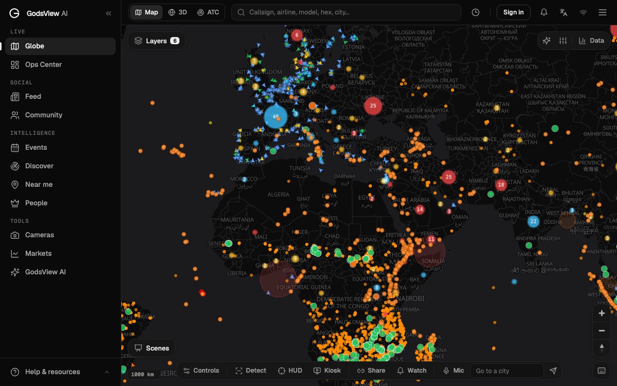
GodsView is a live map and 3D globe of public data. It shows:
- Aircraft from ADS-B on the live flight tracker.
- Ships from AIS on the live ship tracker.
- Satellite positions computed from published orbits on the live satellite tracker.
- Earthquakes, NASA FIRMS fire detections, storms, power outages and news events.
- Public camera streams from agencies and webcam operators on the live traffic cameras page.
It does not show people. It has no access to phones, private cameras, facial recognition or any non-public database. It cannot find a person and it is not a surveillance tool. Every layer comes from a published feed, listed on the methodology page.
The name is a nod to the top-down view of the world, not to the film. People who want a general picture of what is happening, such as a storm, a quake, a busy shipping lane or the ISS passing over, use it the way you might use a weather map. The OSINT map page explains the approach.
"God's eye view" as a camera and film term
Long before the film, "god's eye view" was a filmmaking term. It means a shot taken from directly, or almost directly, above the subject, looking down. No Film School describes the overhead shot as a high-angle shot almost directly or literally directly above the subject, and notes that filmmakers also call it a god's eye shot (No Film School).
Directors use it to make a scene feel watched or judged from above. No Film School points to examples in Alfred Hitchcock's The Birds, Martin Scorsese's Taxi Driver and Brian De Palma's The Untouchables.
The same phrase is used for maps and games that show the world from above, which is where the generic sense of a "god's eye view" map comes from. Our page on viewing a god's-eye map online uses it in that sense.
Open the live satellite tracker
The short answer
God's Eye, the all-seeing program from Furious 7, is fiction. The real world has pieces of the idea: broadcast positions for planes and ships, still images from satellites, scattered public cameras, and government tools governed by courts and law. None of them adds up to a system that can find anyone, anywhere, on demand.
If you want to see what public data can show, open the 3D globe and turn on a few layers. You will see flights, ships, satellites, fires and quakes. You won't see people, and that is by design.
Frequently asked questions
Is God's Eye real?
No. God's Eye is a fictional program from the 2015 film Furious 7. No public or commercial system can locate any person on Earth on demand by tapping phones and cameras.
What is God's Eye in Fast and Furious?
In Furious 7, God's Eye is a computer program created by the hacker Ramsey that can track anyone in the world through digital networks such as phones and cameras. The film's plot is a fight to control it.
Can satellites see people in real time?
No. Imaging satellites take still pictures on a schedule. Free imagery such as Sentinel-2 resolves 10 m per pixel, and the sharpest commercial imagery about 30 cm, enough to see a crowd but not to identify a face.
What does god's eye view mean in film?
It is a camera shot taken from directly or almost directly above the subject, looking down. Directors use it to make a scene feel watched or judged from above.
Is GodsView a surveillance tool?
No. GodsView shows public data only: aircraft, ships, satellite orbits, hazards, news and public camera streams. It has no access to phones, private cameras or facial recognition and cannot track people.
Do police need a warrant to track a phone in the US?
For historical cell-site location records, generally yes. In Carpenter v. United States (2018), the Supreme Court held that getting those records is a Fourth Amendment search that generally requires a warrant.
Sources
- Furious 7 — film summary (Wikipedia)
- FAA — ADS-B privacy
- IMO — AIS transponders
- Copernicus Data Space Ecosystem — Sentinel-2
- USGS — Landsat 9
- Maxar — Fifth and sixth WorldView Legion satellites launched (February 2025)
- US Supreme Court — Carpenter v. United States, 585 U.S. (2018)
- GAO — Facial recognition technology: federal law enforcement agencies (GAO-21-518)
- No Film School — Overhead shots
Facts checked on against each provider's own site.