Wildfires
Italy and Europe Wildfire Map: EFFIS Explained
Europe has one shared fire map, EFFIS, run by the European Commission. Italy has its own national bulletin, a state air fleet and twenty regional systems. Here is how the pieces fit, and which map to open for which question.
Key takeaways
- For a live view of fires in Italy, use a satellite hotspot map such as the GodsView Italy fire page, then check EFFIS for mapped burnt areas and fire danger.
- EFFIS is the European Forest Fire Information System, run by the Commission's Joint Research Centre and part of Copernicus since 2015. Its network includes experts from 43 countries.
- EFFIS fire danger maps use the Canadian Fire Weather Index. A high danger class means fire would spread easily, not that anything is burning.
- EFFIS burnt area maps are drawn from MODIS, VIIRS and Sentinel imagery and cover about 95% of the area that burns in the EU each year.
- In Italy, the regions lead firefighting on the ground. The national Civil Protection Department runs the state air fleet through COAU and issues a daily fire danger bulletin.
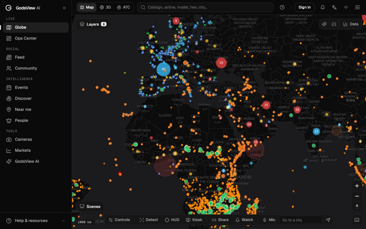
To see wildfires in Italy right now, open a satellite fire map, such as the GodsView page for fires in Italy, which groups recent heat detections into fire clusters named after the nearest town. Then check EFFIS, the European Forest Fire Information System, for two things a hotspot map does not give you: the mapped outline of burnt areas, and the fire danger forecast for the coming days. For anything you need to act on, such as road closures or evacuations, follow the regional authorities, the Vigili del Fuoco and your comune.
This guide explains what EFFIS is and how to read it, how wildfire response works in Italy, and how Greece, Spain and Portugal differ. If you are new to satellite fire maps, the NASA FIRMS explainer covers hotspots in more detail.
What is EFFIS?
EFFIS is the European Forest Fire Information System. The European Commission set it up "in collaboration with the national fire administrations", and it has run since 1998. It is operated by the Commission's Joint Research Centre (JRC) and has been part of the Copernicus Emergency Management Service since 2015. Its expert network includes people from 43 countries across Europe, the Middle East and North Africa (EFFIS).
EFFIS covers the whole fire cycle: fire danger before a fire, active fires and burnt area mapping during the season, and emissions, soil loss and vegetation recovery afterwards. Most people only use the first two, through its Current Situation viewer.
It is a European information service, not a firefighting agency. EFFIS does not send aircraft or order evacuations. National and regional authorities do.
How to read the EFFIS current situation viewer
The viewer is a web map of Europe and the Mediterranean with layers you can switch on and off. The main ones answer three different questions.
| Layer | Question it answers | Where it comes from |
|---|---|---|
| Fire danger forecast | How easily would a fire start and spread on a given day? | Fire Weather Index computed from weather forecasts |
| Active fires | Where has a satellite seen heat in the last day or so? | Satellite thermal detections (MODIS, VIIRS and others) |
| Burnt areas | What area has a fire already burned? | Perimeters mapped from satellite images by analysts |
A good habit is to keep only one of these on at a time until you know what you are looking at. A red fire danger map, a dot of active fire and a burnt area polygon can sit on top of each other and look like the same thing. They are not.
Fire danger forecast
EFFIS uses the Canadian Forest Fire Weather Index (FWI) System. The EFFIS network adopted it in 2007, after five years of testing, as a way to rate fire danger in the same way across every country. The forecast is computed from the ECMWF weather model, at about 8 km resolution, for 1 to 9 days ahead, and from Météo-France's model for up to 3 days (EFFIS fire danger forecast).
The map uses six classes: Low, Moderate, High, Very High, Extreme and, since June 2021, Very Extreme.
Fire danger is about weather and fuel. It combines temperature, humidity, wind and rain into a number. A day in the Very Extreme class is a day when a fire, once started, would be very hard to stop. It does not mean a fire is burning.
Active fires
Active fire layers show heat detected by satellites. They are the fastest signal that something is burning, and also the noisiest. Industrial sites, gas flares and solar panels can produce heat signatures. EFFIS notes that its analysts check burnt areas so that "non-fire heat sources, such as photovoltaic installations, are not mistakenly mapped as burned areas" (JRC).
Burnt areas
The burnt area layer is what makes EFFIS different from a plain hotspot map. Its Rapid Damage Assessment module started in 2003, mapping burnt areas from MODIS images at 250 m resolution. Until 2017 it mapped fires of about 30 hectares or larger. Since 2018, Sentinel-2 images let it map smaller fires and refine the outlines of bigger ones. EFFIS estimates that the areas it maps "represent about 95% of the total area that burns in the EU every year", and it processes two full image mosaics of Europe every day (EFFIS Rapid Damage Assessment).
The JRC adds that fire perimeters "are updated and refined when more recent or higher resolution imagery is available", up to eight times a day (JRC).
Two practical points follow:
- A burnt area appears after the fire. It is drawn from images of scorched ground, so it lags the flames.
- EFFIS area totals are a mapping estimate. National agencies may publish different numbers using ground surveys. Both are useful; they are not the same count.
How wildfire response works in Italy
Italy's system rests on the framework law on forest fires, law 353 of 21 November 2000. Responsibility is shared (Protezione Civile):
- The regions handle forecasting, prevention and active firefighting, with their own staff, volunteers and helicopters. Each region writes a three-year fire plan, updated every year.
- The Department of Civil Protection coordinates the state air fleet through COAU, the Centro Operativo Aereo Unificato. COAU is active 24 hours a day all year and is "the Command and Control Center of all the aircrafts made available for the State's contribution in the forest fire fighting activity". The fleet includes Canadair CL-415 water bombers and S-64 helicopters.
- The Vigili del Fuoco (the national fire and rescue service) and the forestry corps carry out ground operations, under a framework agreement from 2008 that sets out who does what.
Each year the Prime Minister sets the timing of the summer and winter fire campaigns (campagna AIB, antincendio boschivo).
The national fire danger bulletin
The Civil Protection Department produces a daily national forest fire forecast bulletin. It gives a probabilistic forecast of how easily fires could start and spread, in three levels, bassa, media and alta (low, medium, high), for up to 24 hours ahead, with a trend beyond that (Protezione Civile). It goes to regions, prefectures and emergency services, and it is one of the inputs used to decide where to position the air fleet.
Forecasting is also a regional job under the national law. If you live in Italy, your region's civil protection site is the place to look for local fire danger and any summer restrictions.
Sicily and Sardinia
The two big islands run their own forestry services, and that is where many of Italy's largest summer fires happen.
- Sicily. The Corpo Forestale della Regione Siciliana is "the key operational structure for prevention and firefighting" in the region. It works through nine provincial forest inspectorates, 85 local detachments and a regional operations centre that runs the free 1515 environmental emergency line around the clock (Regione Siciliana).
- Sardinia. The regional Corpo forestale e di vigilanza ambientale handles "planning, forecasting and coordination" for forest fires and fire campaigns, along with the island's fire statistics and the communication and remote sensing systems used to detect fires (Regione Sardegna).
On GodsView, the town pages narrow the satellite view to one place, for example wildfires near Palermo or wildfires near Cagliari. Each shows the nearest fire clusters, wind and humidity, and links back to the official sources.
Greece, Spain and Portugal: the national fire danger maps
EFFIS covers all of Europe with one method. Each country also publishes its own fire danger product, and these are what local authorities act on.
| Country | Who publishes the fire danger map | How it is graded | GodsView page |
|---|---|---|---|
| Italy | Civil Protection Department (national bulletin) plus regions | Low, medium, high | Fires in Italy |
| Greece | General Secretariat for Civil Protection | Five colour-coded levels, green (low) to red (extreme) | Fires in Greece |
| Spain | AEMET, the state weather agency | Six levels, very low to extreme, using the FWI at 1 km | Fires in Spain |
| Portugal | IPMA, the weather institute, by municipality | Levels up to "very high" and "maximum", with activity restrictions | Fires in Portugal |
Greece. The fire risk forecast map comes from the General Secretariat for Civil Protection. It uses five colour-coded levels: green for low, blue for moderate, yellow for high, orange for very high and red for extreme (To Vima).
Spain. AEMET publishes a daily meteorological fire danger forecast in six levels, from very low to extreme. It uses the Canadian FWI system at 1 km resolution over the peninsula, the Balearic Islands and the Canary Islands, and it measures weather danger, not fire activity (AEMET).
Portugal. IPMA's rural fire danger product works at the level of each municipality (concelho). Its top levels, "very high" and "maximum", trigger restrictions on activities such as burning and the use of forest machinery (IPMA).
The common thread: three of the four build on the same Canadian Fire Weather Index that EFFIS uses. When the EFFIS map and a national map disagree, it is usually because of different weather models, resolutions or class boundaries, not different science. The Canada wildfire map guide explains where the index comes from.
EFFIS vs NASA FIRMS vs GodsView: which map to open
These tools overlap, but each is best at one job.
| Tool | Best for | Not good for |
|---|---|---|
| EFFIS current situation viewer | Fire danger forecasts and mapped burnt areas across Europe | A quick answer about one town |
| NASA FIRMS | Raw satellite hotspots worldwide, with detection time and fire radiative power | Fire outlines and fire danger |
| GodsView fire pages | A plain-language answer per country, region or town, with clusters, nearby cities and official links | Official perimeters or evacuation orders |
| Regional and national services | Official status, closures, evacuations | A Europe-wide overview |
On GodsView, the live wildfire map shows NASA's satellite detections on the full map, so you can pan across the Mediterranean in one view. Country pages like Greece, Spain and Portugal answer the question directly: how many fire clusters, how intense, which towns are close, and when each was last seen. The official information section on those pages points to EFFIS and the national civil protection authority.
How to follow a fire near a place you know
Summer fires in southern Europe often affect people who don't live there: holiday homes, family, a trip next week. A few steps help.
- Check the fire danger forecast before you go. EFFIS for the overview, the national map for the detail.
- Watch the place, not the map. On My places, add the town and press Watch. GodsView checks a 50 km circle for wildfires, severe weather warnings, earthquakes and bad air, and alerts you in the app, by browser push or by email. Alerts need a paid plan. The alerts tutorial shows the steps.
- Keep an eye on smoke. Smoke can spoil the air far from the flames. Pages such as air quality in Athens show the current reading.
- Know the emergency number. 112 works across the EU.
If you only want a quick answer to "is anything burning near me?", the fire near me guide is the short version.
What these maps cannot tell you
- A danger map is not a fire map. It is a forecast of how weather would treat a fire.
- Hotspots are not perimeters. A cluster of dots shows heat seen from orbit, at a few passes a day.
- Burnt areas lag. They are drawn after the ground is visibly scorched.
- None of these maps orders an evacuation. That comes from local authorities and the emergency services.
Use EFFIS to understand the season, a hotspot map to see today's fires, and local authorities to decide what to do.
Frequently asked questions
Is there a live wildfire map for Italy?
Yes. Satellite hotspot maps such as the GodsView Italy fire page and NASA FIRMS show recent heat detections. EFFIS adds mapped burnt areas and the fire danger forecast. Official status and evacuations come from regional authorities and the Vigili del Fuoco.
What is EFFIS?
The European Forest Fire Information System. It was set up by the European Commission with national fire services, has run since 1998, is operated by the Joint Research Centre and has been part of the Copernicus Emergency Management Service since 2015.
What do the EFFIS fire danger colours mean?
They are classes of the Fire Weather Index: Low, Moderate, High, Very High, Extreme and Very Extreme. They describe how easily a fire would start and spread under the forecast weather. They do not show actual fires.
How accurate are EFFIS burnt area maps?
EFFIS maps burnt areas from MODIS, VIIRS and Sentinel-2 imagery, checked by analysts, and estimates it captures about 95% of the area that burns in the EU each year. Small fires may be missed and outlines are refined as better images arrive.
Who fights wildfires in Italy?
The regions lead prevention and ground firefighting with their own crews and volunteers. The Vigili del Fuoco and forestry corps work on the ground, and the national Civil Protection Department runs the state air fleet, including Canadair water bombers, through COAU.
What number do I call to report a fire in Sicily?
Call 112 for any emergency. Sicily's regional forestry corps also runs the free 1515 environmental emergency line from its regional operations centre, around the clock.
Sources
- EFFIS: About EFFIS
- EFFIS: Fire danger forecast (technical background)
- EFFIS: Rapid Damage Assessment (technical background)
- European Commission JRC: Current wildfire situation in Europe
- Protezione Civile: Forest fire risk, activities
- Protezione Civile: National forest fire forecast bulletin
- Regione Siciliana: Corpo Forestale competences
- Regione Sardegna: Corpo forestale e di vigilanza ambientale
- AEMET: Forest fire danger forecast, interpretation
- IPMA: Rural fire danger
Facts checked on against each provider's own site.