Guide
Live GPS Satellite Map: See Which GPS Satellites Are Overhead
GPS satellites fly far higher than the ISS or Starlink, in a pattern built so that at least four are always above you. Here is how to see them on a live map, and what your phone is doing with them.
Key takeaways
- GPS satellites orbit at about 20,200 km in six orbital planes and circle Earth twice a day. GPS.gov counted 31 operational satellites in its last published update.
- Your phone usually listens to several systems at once: GPS, Galileo, GLONASS, BeiDou and regional ones such as QZSS.
- A position fix needs at least four satellites. How they are spread across the sky, measured as DOP, affects accuracy as much as how many there are.
- ESA counts about 47,370 objects regularly tracked by space surveillance networks as of November 2026.
- The free GodsView satellite layer includes operational GPS and Galileo satellites, computed from CelesTrak orbital elements and refreshed hourly.
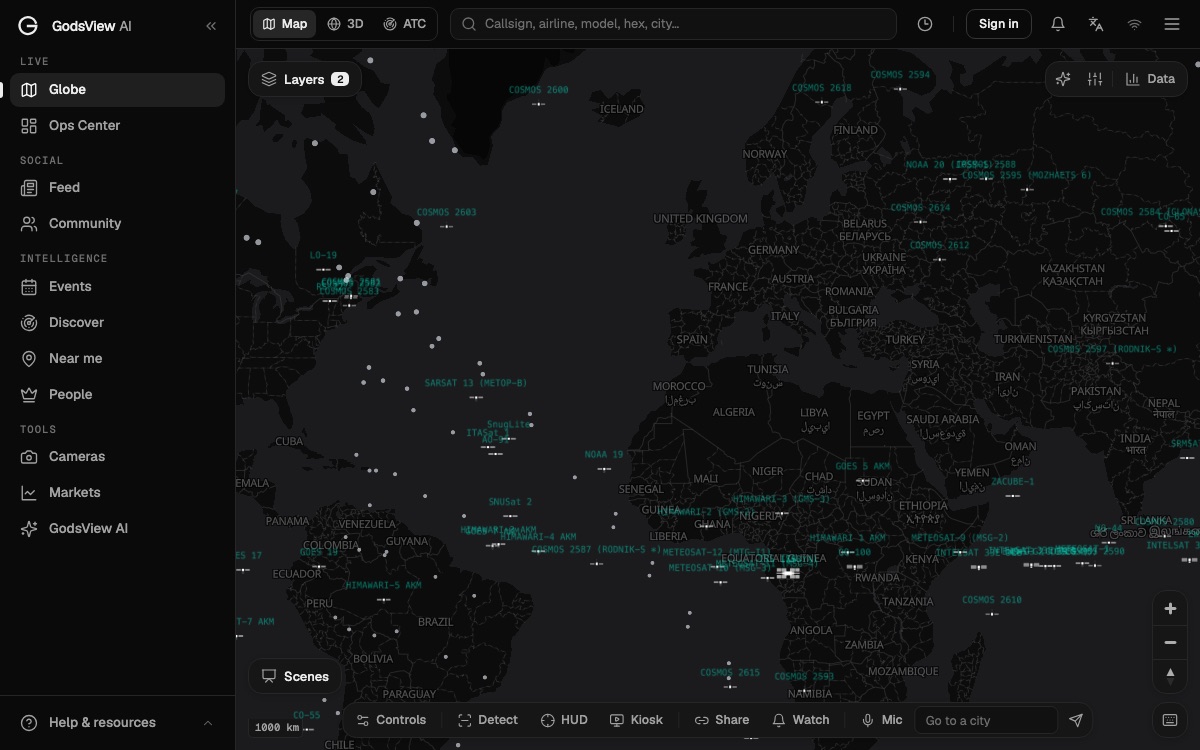
A live GPS satellite map shows where the satellites of the Global Positioning System are right now, computed from their published orbits. On GodsView, open the live satellite tracker: the free satellite layer includes the operational GPS group from CelesTrak, along with Galileo, weather, Earth observation and other satellites. Click any dot to see its name and catalog number.
At any moment, several GPS satellites are above your horizon, wherever you are. They sit much higher than the ISS, and they are spaced so that a receiver can always see at least four. This guide explains how the GPS constellation is laid out, how it compares with Galileo, GLONASS and BeiDou, how your phone picks which satellites to use, and how many objects are tracked in orbit overall.
See GPS satellites on the live map
How the GPS constellation is built
GPS is operated and maintained by the US Space Force. According to GPS.gov, the satellites fly in medium Earth orbit (MEO) at about 20,200 km (12,550 miles), and each one circles the Earth twice a day.
The design starts from 24 slots. The satellites are spread across six equally spaced orbital planes, with four baseline slots in each plane. GPS.gov says this arrangement means users can see at least four satellites from virtually any point on the planet. In June 2011 the Air Force completed an expansion known as "Expandable 24", which turned the design into an effective 27-slot constellation with better global coverage.
The constellation usually holds more satellites than the baseline needs. GPS.gov reported 31 operational satellites as of July 3, 2023, the most recent figure it publishes. Extra satellites fill gaps when older ones are serviced or retired. The exact count changes as new GPS III satellites launch and old ones are set aside, so treat any number on a website as a snapshot.
Two figures help put that orbit in context:
- The ISS flies at roughly 400 km, about one fiftieth of the GPS altitude.
- Starlink satellites also work in low Earth orbit, only a few hundred kilometers up.
That height is why a GPS satellite moves slowly across your sky compared with the ISS. A low satellite crosses in minutes. A GPS satellite can stay above your horizon for hours.
GPS is not alone: Galileo, GLONASS and BeiDou
"GPS" has become shorthand for satellite navigation, but there are four global systems. The general term is GNSS, for global navigation satellite system.
| System | Operator | Orbit height | Planes | Notes |
|---|---|---|---|---|
| GPS | United States | About 20,200 km | 6 | 24-slot baseline, expanded to 27; 31 operational as of July 2023 |
| Galileo | European Union | 23,222 km | 3 | Inclined 56 degrees; 26 satellites listed as usable by the GSC |
| GLONASS | Russia | 19,100 km | 3 | 24 operational satellites in the nominal design, inclined 64.8 degrees |
| BeiDou | China | MEO plus geostationary and inclined geosynchronous | Mixed | BDS-3 commissioned for global service on July 31, 2020 |
Galileo. The European GNSS Service Centre describes satellites spread evenly around three orbital planes at 23,222 km, inclined 56 degrees, each taking about 14 hours per orbit (GSC). It says six to eight Galileo satellites will always be visible from most places. When we checked the GSC constellation status page on November 10, 2026, it listed 30 Galileo satellites, 26 of them marked usable.
GLONASS. ESA's Navipedia describes the nominal GLONASS constellation as 24 operational satellites in three planes at 19,100 km, inclined 64.8 degrees, with an orbital period of about 11 hours 15 minutes (Navipedia). The steeper inclination helps at high northern latitudes.
BeiDou. China's system mixes satellite types. Alongside medium Earth orbit satellites, it uses satellites in geostationary orbit and in inclined geosynchronous orbit, which stay over the Asia-Pacific region (Navipedia). China officially commissioned BDS-3 for global users on July 31, 2020, according to the Chinese government.
There are also regional systems, such as Japan's QZSS and India's IRNSS (NavIC), plus augmentation satellites (SBAS) that broadcast corrections.
How your phone picks satellites
Your phone does not choose one system. Modern chips listen to several at once and combine them. Android's location API, for example, labels every satellite a phone can see with its constellation: GPS, SBAS, GLONASS, QZSS, BeiDou, Galileo or IRNSS (Android GnssStatus).
For each satellite, the phone knows:
- Its ID number within that constellation. GPS satellites use numbers 1 to 32.
- Elevation and azimuth: how high in the sky it is and in which direction.
- Signal strength (carrier-to-noise density, in dB-Hz).
- Whether it has the satellite's orbit data, called ephemeris and almanac.
- Whether it used that satellite in the most recent position fix.
That last flag matters. A phone may see 30 satellites and use only some of them, dropping weak or blocked signals. GNSS test apps on Android read this API and draw a "sky plot" of the satellites your phone is using right now. That is the most direct way to see which GPS satellites are overhead from where you stand.
Why you need at least four
Each satellite broadcasts a signal with very precise timing. Your receiver measures how long the signal took to arrive and turns that into a distance. With distances to several satellites at known positions, it can solve for where you are.
There are four unknowns: your three coordinates (east-west, north-south, height) and the error in your receiver's clock. Four unknowns need at least four measurements, which is why GPS was designed so that at least four satellites are always visible.
What DOP means, and why satellite geometry matters
Having enough satellites is not the whole story. Where they sit in the sky matters too.
Dilution of precision (DOP) is a number that describes how the geometry of the satellites affects your fix. ESA's Navipedia defines DOP as an approximate ratio between the precision of the measurements and the precision of the position (Navipedia). It depends only on the geometry between the receiver and the satellites, not on the measurements themselves, so it can be computed in advance.
A simple picture helps. If all your satellites are bunched in one corner of the sky, the lines from you to them are nearly parallel and small errors grow into large position errors. If they are spread out, with some high and some low in different directions, the lines cross at wide angles and the fix is tight. Low DOP is good. High DOP is bad.
There are several flavors:
- GDOP: the geometric effect on position and time together.
- PDOP: position in three dimensions.
- HDOP: horizontal position only, the one that matters for a map.
- VDOP: height. It is usually worse than HDOP, because all the satellites you can see are above you, never below.
This is one reason multi-system phones work better in cities. Street canyons block much of the sky. More satellites from more systems means a better chance of finding a good spread in the slice of sky that remains.
How accurate is GPS on a phone?
GPS.gov says GPS-enabled smartphones are typically accurate to within a 4.9 m (16 ft) radius under open sky (GPS.gov). It also says accuracy worsens near buildings, bridges and trees, indoors and underground, and when signals reflect off structures (called multipath).
The same page notes that dual-frequency receivers can correct for signal distortions caused by the atmosphere. Newer GPS satellites add civil signals at L2 and L5 for exactly this reason.
Not every error comes from geometry or buildings. Deliberate interference is a growing problem. Jamming drowns the weak satellite signals in noise. Spoofing sends fake signals that make a receiver compute the wrong position. Our GPS jamming and spoofing explainer covers both, and the GPS jamming map shows reported interference zones next to live flights.
How many objects are tracked in orbit?
GPS satellites are a tiny part of what is up there. ESA's Space Debris Office publishes running totals in its space environment statistics. As of November 2, 2026, it listed:
| Measure | ESA figure |
|---|---|
| Rocket launches since 1957 (excluding failures) | About 7,400 |
| Satellites placed in orbit | About 28,570 |
| Satellites still in space | About 19,610 |
| Satellites still functioning | About 15,800 |
| Objects regularly tracked by space surveillance networks | About 47,370 |
| Estimated objects larger than 10 cm (model) | About 68,450 |
The gap between the last two rows is important. Many objects big enough to cause damage are not in any public catalog. A space object tracker can only show what has been measured and published.
Where the catalog data comes from
The US Space Force maintains the main public catalog and publishes it on Space-Track.org, which requires a free account. CelesTrak republishes the same data in convenient groups, including separate groups for GPS and Galileo satellites. Most online satellite trackers read from one of the two.
The data comes as orbital elements, not live positions. A tracker computes each satellite's position from those elements with a model called SGP4. The satellite tracking guide explains what is inside a two-line element set and how the error grows as data ages.
Live satellite tracking on GodsView
GodsView's satellite layer loads several CelesTrak groups, refreshed hourly. That includes space stations, weather and NOAA satellites, GPS operational, Galileo, geostationary satellites, Earth resources, science, military, amateur and a sample of Starlink. Positions are computed on the server and drawn on the map or the 3D globe.
How to see GPS satellites:
- Open the live satellite tracker. It opens on the 3D globe with satellites on.
- Zoom out until you see the whole Earth. GPS satellites sit far out, so they look spread thinly around the planet compared with the dense low-orbit swarm.
- Click a satellite to see its name and catalog number. GPS satellites carry names that start with "GPS" followed by their block, such as BIIR, BIIF or BIII.
- Turn off other layers to make the orbits easier to read.
| What you want | Where on GodsView | Plan |
|---|---|---|
| GPS and Galileo satellites on a map | Live satellite tracker | Free |
| Where the ISS is now | ISS tracker | Free |
| Starlink constellation | Starlink tracker | Plus |
| Reported GPS interference zones | GPS jamming map | Plus |
| Close approaches between objects | Conjunctions (CelesTrak SOCRATES) | Pro |
Plus costs $10.99 a month or $99.99 a year as of November 2026.
What GodsView does not do: it does not show GLONASS or BeiDou as separate groups, it does not compute DOP for your location, and it does not show which satellites your own phone is using. For that last one, a GNSS test app on your phone is the right tool.
Limits of any live GPS satellite map
- Positions are predictions. They come from published orbital elements, not from live telemetry.
- Health is not shown. A satellite can be in orbit and in the catalog but set unhealthy by its operator. Your phone ignores it; a map may still draw it.
- Not every object is public. Some objects are not in the public catalog, and many small fragments are not tracked at all.
- Interference is invisible. A map of satellites can't tell you whether their signals are reaching you. See the GPS jamming map for reported problem areas.
For low, bright satellites you can see with your eyes, the guides on tracking the ISS in real time and seeing Starlink satellites tonight are the better starting point. GPS satellites are too far away and too faint to spot without a telescope.
Frequently asked questions
How many GPS satellites are there?
GPS.gov reported 31 operational GPS satellites as of July 3, 2023, its latest published figure. The constellation is built around a 24-slot baseline in six orbital planes, expanded to 27 slots in 2011, and the count changes as new satellites launch and old ones retire.
Can I see GPS satellites on a live map?
Yes. The free GodsView live satellite tracker includes the operational GPS and Galileo groups from CelesTrak, refreshed hourly. Positions are computed from orbital elements, not received from the satellites.
How many GPS satellites does my phone need?
At least four, to solve for three position coordinates and the error in the receiver clock. Most phones also use Galileo, GLONASS and BeiDou satellites, which gives more choice and better geometry.
What is DOP in GPS?
Dilution of precision describes how the geometry of the satellites in view affects accuracy. Satellites spread widely across the sky give a low, good DOP; satellites bunched together give a high, poor DOP.
How high are GPS satellites?
About 20,200 km (12,550 miles), in medium Earth orbit. Each one circles the Earth twice a day. That is roughly fifty times higher than the ISS.
How many objects are tracked in space?
ESA counted about 47,370 objects regularly tracked by space surveillance networks as of November 2, 2026, and estimated about 68,450 objects larger than 10 cm in orbit.
Sources
- GPS.gov — GPS space segment
- GPS.gov — GPS accuracy
- European GNSS Service Centre — Galileo programme
- European GNSS Service Centre — Galileo constellation information
- ESA Navipedia — GLONASS space segment
- ESA Navipedia — BeiDou space segment
- ESA Navipedia — Positioning error and DOP
- Government of China — BeiDou enters new phase (BDS-3 commissioned July 31, 2020)
- Android Developers — GnssStatus
- ESA Space Debris Office — Space environment statistics
- CelesTrak — Current GP element sets
Facts checked on against each provider's own site.