How-to
Is a Volcano Erupting Right Now? How to Check Live Activity
A headline mentions an eruption, or a friend is flying past a smoking mountain, and you want to know what is actually happening. Here is how to check a volcano's status in a few minutes, and why the answer is often "it depends who you ask".
Key takeaways
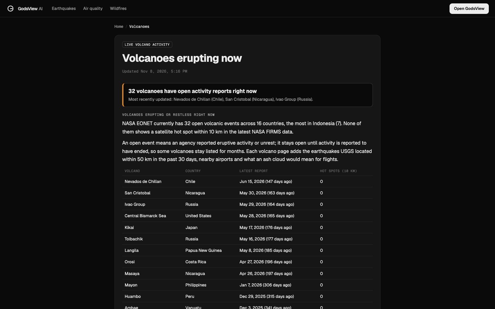
- For a quick worldwide answer, open a live volcano list such as GodsView's volcanoes page. On November 8, 2026 it showed 32 volcanoes with open NASA EONET activity reports, 7 of them in Indonesia.
- For one volcano, the local observatory is the authority. In the US that is the USGS, which uses four alert levels: Normal, Advisory, Watch and Warning.
- "Open activity report" does not mean lava right now. Many volcanoes erupt on and off for months or years, and a report stays open until activity is declared over.
- Earthquake swarms near a volcano are common and most end without an eruption. Observatories combine them with ground deformation and gas data.
- Volcanic ash is a flight hazard far from the volcano. Volcanic Ash Advisory Centres issue the advisories airlines follow.
Yes: on any given day several dozen volcanoes around the world are erupting or restless. The quickest way to see which ones is a live list built from official reports, such as GodsView's volcanoes erupting now page; to know what a specific volcano is doing today, check its national volcano observatory, which sets the official alert level. On November 8, 2026, the GodsView list showed 32 volcanoes with open activity reports from NASA's Earth Observatory Natural Event Tracker (EONET), across 16 countries.
That's the short answer. The longer one matters, because "erupting" covers everything from a lava lake glowing quietly in a crater to an ash column that grounds flights across a continent. Here's how to check, and how to read what you find.
Which volcanoes are erupting today?
Open the volcanoes page. The top table lists every volcano with an open NASA EONET event: the volcano, the country, the date of the latest report and whether a satellite saw a heat signature within 10 km of the summit.
On November 8 the most recently updated were Nevados de Chillán in Chile, San Cristóbal in Nicaragua and the Ivao Group in Russia. Indonesia had the most open events, seven. Below that table, the page lists volcanoes whose last significant eruption was in 1990 or later, and every volcano that has erupted since 1900, grouped by country. In all, GodsView tracks 1,609 volcanoes from NOAA's National Centers for Environmental Information (NCEI) database plus EONET, and gives a page to 484 that have erupted since 1900 or are active now.
What "open activity report" actually means
EONET opens an event when an agency, usually the Smithsonian Institution's Global Volcanism Program, reports eruptive activity or unrest at a volcano. The event stays open until activity is reported to have ended (NASA EONET). So the list is "volcanoes in an active phase", not "volcanoes with lava pouring out this minute".
That's why some dates look old. On November 8, 2026, Kīlauea's open event was dated December 23, 2024, the day a new summit eruption began. Through 2025 that eruption came in episodes of lava fountaining with pauses of days or weeks in between. An old date doesn't mean nothing has happened since; it means you need the observatory's daily update for today's state.
Two more sources are better for "this week":
- The Smithsonian/USGS Weekly Volcanic Activity Report summarises new and continuing activity worldwide every week (Smithsonian GVP).
- National observatories post daily or more frequent updates: the USGS volcano observatories in the US, plus agencies such as Japan's JMA, Italy's INGV, Indonesia's PVMBG and Iceland's Met Office.
How to check one volcano: alert levels, earthquakes and heat
Every volcano GodsView covers gets its own page. Take Kīlauea: the page shows its status now, its type and elevation, when it last erupted, the nearest city, the earthquakes USGS located within 50 km in the last 30 days, and any satellite hot spots within 10 km.
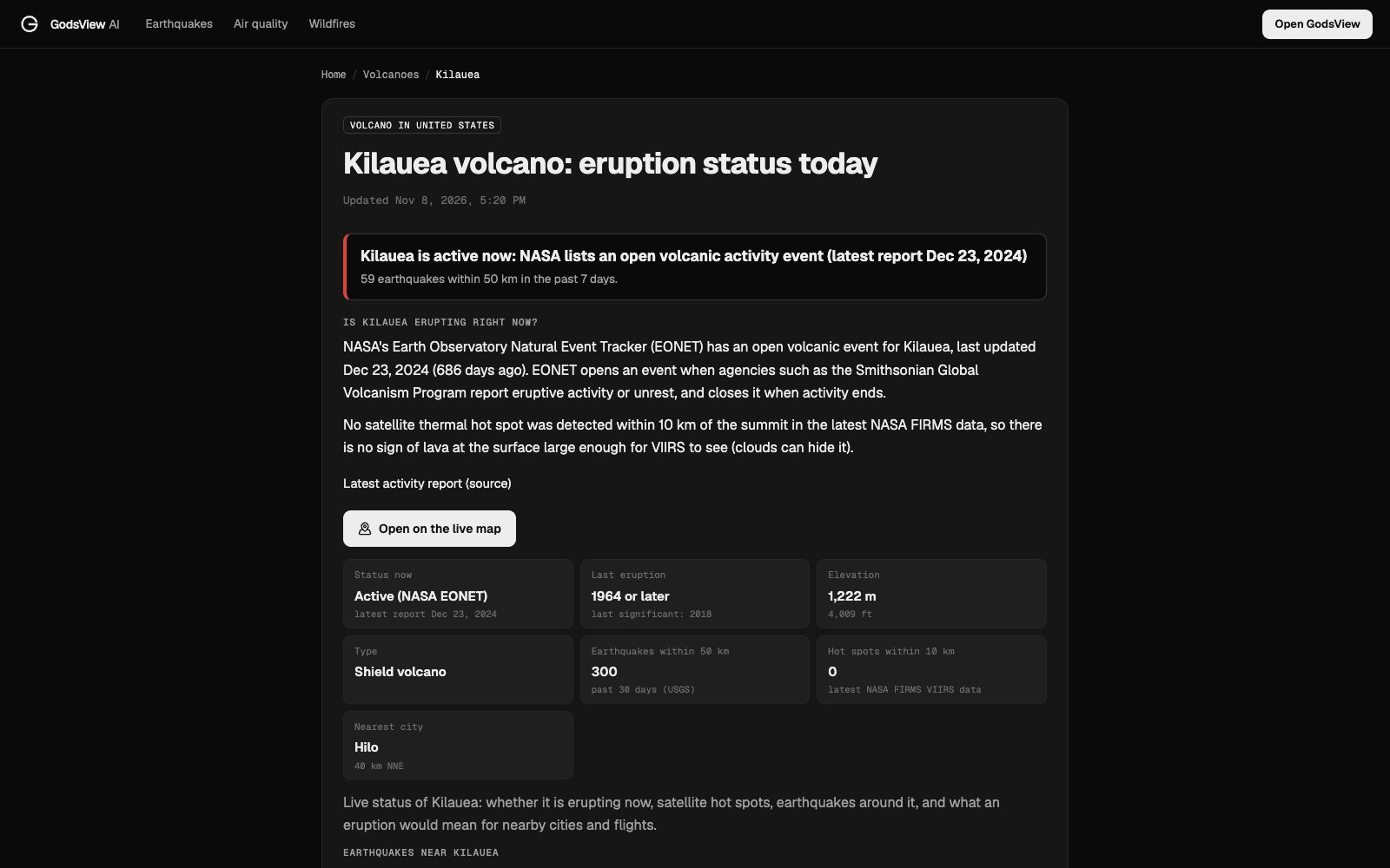
Here's how to read each piece.
The official alert level. This is the observatory's judgment, and it's the number to act on. The USGS uses a four-step Volcano Alert Level for people on the ground and a four-colour Aviation Color Code for ash in the air (USGS):
| Volcano Alert Level | What it means | Aviation Color Code |
|---|---|---|
| Normal | Typical background, non-eruptive state | Green |
| Advisory | Elevated unrest above background | Yellow |
| Watch | Heightened or escalating unrest with more potential for eruption, or an eruption with limited hazards | Orange |
| Warning | Hazardous eruption imminent, underway or suspected | Red |
Other countries use their own scales (Indonesia has four levels, Japan five), so always read the level on the national observatory's page.
Earthquakes nearby. GodsView lists USGS earthquakes within 50 km. Near Kīlauea on November 8 that was 300 in 30 days, 59 in the last week, the largest M3.3. That sounds alarming and isn't: Hawaiʻi's volcanoes produce small quakes constantly. Shallow swarms can mean magma or gas is moving, but most swarms end without an eruption, which is why observatories combine them with ground deformation and gas measurements. If you want to read an earthquake table properly, see how to read an earthquake map.
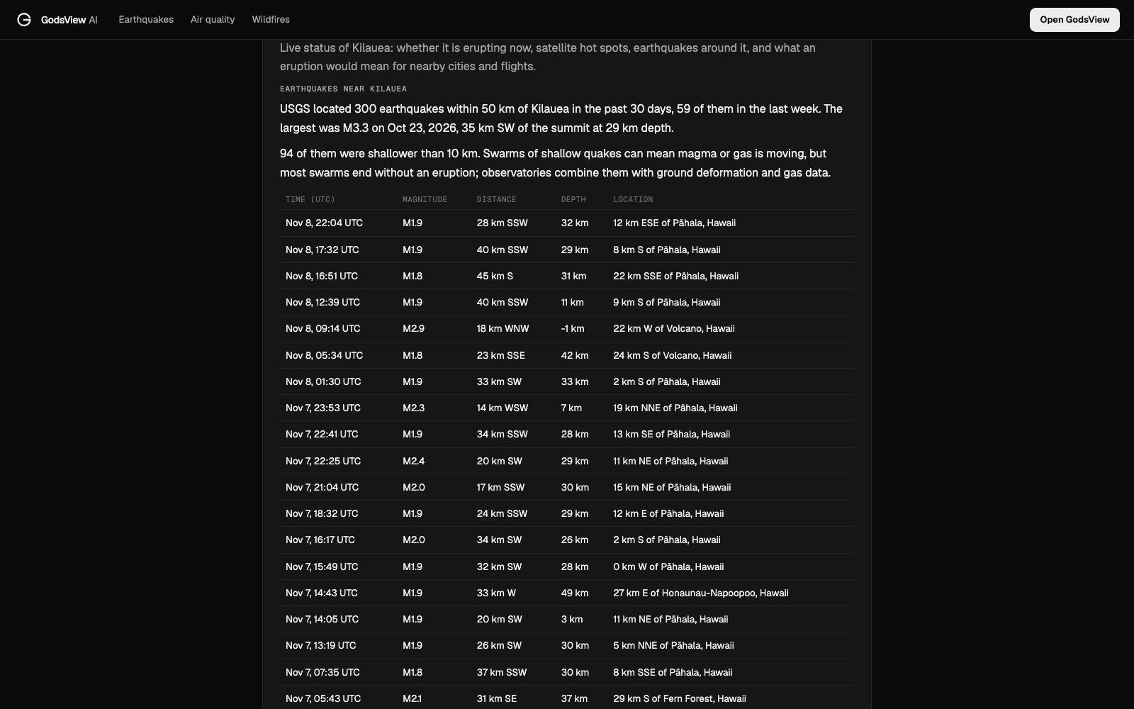
One caution: outside the US, USGS mainly lists quakes above about M4, so the volcanic tremor a local observatory records won't show up. Etna's page, for example, shows no USGS quakes within 50 km in 30 days even though Italy's INGV records small events there all the time.
Satellite hot spots. GodsView checks NASA FIRMS VIIRS detections within 10 km of the summit. A hot spot means something on the surface was hotter than its surroundings when the satellite passed: often lava, sometimes a lava lake. No hot spot doesn't prove there's no lava; cloud, ash and the gap between passes can hide it. Our NASA FIRMS explainer covers how those detections work.
Volcanic ash and flights
If you're flying, ash matters more than lava. Volcanic ash is pulverised rock and glass; it melts inside jet engines and can stop them. That's why an explosive eruption can close airspace and cancel flights hundreds or thousands of kilometres downwind, as Iceland's Eyjafjallajökull did across Europe in 2010.
Each GodsView volcano page lists the major airports within 400 km and their direction. The official ash forecasts come from the nine Volcanic Ash Advisory Centres (VAACs), set up under the International Civil Aviation Organization, each covering a region of the world. Airlines and air traffic control act on their advisories; your airline's app is the best place to see whether your own flight is affected. To watch what aircraft are doing around an eruption, open the live flight map and look for gaps where traffic normally flows.
Can I see volcanoes on a live map?
Yes. Volcanoes are a free layer on the GodsView live map, alongside earthquakes, fires, flights and weather. Each volcano page also has an Open on the live map button that centres the globe on it. That's handy when you want the context in one view: the volcano, the quakes around it, the planes routing near it and any news reports from the area.
Volcano alerts near home
If you live near a volcano, sign up for the official notifications first. In the US, the USGS Volcano Notification Service emails updates for the volcanoes you choose. Most countries with active volcanoes run something similar through their observatory or civil protection agency.
GodsView can also alert you. When you save a place on My places or draw a watch area, a Volcano alert rule (from GDACS, the Global Disaster Alert and Coordination System) is available. It's off by default for home places, so switch it on if a volcano is near you. Saving watches and getting alerts needs GodsView Plus or Pro. The full setup is in how to get disaster alerts near home.
Not every eruption looks the same
"Erupting" covers very different events, and the kind of eruption decides who should worry.
- Effusive eruptions pour out runny lava as fountains, flows and lava lakes. Hawaiʻi's shield volcanoes are the classic case. They destroy what's in the lava's path but rarely threaten people who follow evacuation orders, and they often become sightseeing events.
- Explosive eruptions blast out ash, gas and rock. Stratovolcanoes such as Mount St. Helens, Pinatubo or Indonesia's volcanoes are built from these layers. The danger comes from ash columns, ashfall on towns, and pyroclastic flows: fast, hot avalanches of gas and debris.
- Lahars are volcanic mudflows, made when eruptions melt snow and ice or when rain remobilises loose ash. They can travel tens of kilometres down river valleys, which is why volcanoes like Mount Rainier are watched closely even when quiet.
- Gas matters too. Volcanic smog ("vog") from Kīlauea drifts across Hawaiʻi and can affect people with asthma well away from the summit.
Scientists rank explosive size with the Volcanic Explosivity Index (VEI), from 0 for gentle lava to 8 for super-eruptions. Each step is roughly ten times more erupted material. Most eruptions in any given year are VEI 0 to 2. The volcano type on each GodsView page (shield, stratovolcano, caldera and so on) gives you a first idea of which kind to expect.
How to read a volcano news headline
Volcano headlines often sound more dramatic than the observatory's own update. A few checks help:
- Find the alert level. "Volcano rumbles" with an alert level of Advisory or Yellow is unrest, not an eruption.
- Check the date. Old eruption videos get recirculated on social media during every new event.
- Check the distance. An ash plume at a remote volcano can matter for flights and very little for people on the ground.
- Read the observatory, not the aggregator. The national observatory's update says what was observed, when, and what's expected next.
Volcanoes people check most
A few volcanoes come up again and again in searches, usually because millions of people live near them or because they erupt often:
- Kīlauea, Hawaiʻi: one of the most active volcanoes on Earth; mostly effusive lava rather than explosive ash.
- Etna, Sicily: frequent eruptions and lava fountains, about 29 km from Catania. Check earthquakes near Catania for the regional picture.
- Mount St. Helens, Washington: famous for 1980; monitored closely by the USGS Cascades Volcano Observatory.
- Mount Rainier, Washington: not erupting, but studied closely because of the towns built on old mudflow deposits around it.
For everything else, the country lists on the volcanoes hub link to each volcano's page.
Frequently asked questions
Is any volcano erupting right now?
Almost always. On November 8, 2026, NASA EONET had 32 open volcanic events in 16 countries, listed on the GodsView volcanoes page. For the current state of a specific volcano, check its national observatory.
Where can I see a live volcano map?
Volcanoes are a free layer on the GodsView live map, and every volcano page has an Open on the live map button. The Smithsonian Global Volcanism Program also publishes a weekly activity report.
What do the volcano alert levels mean?
In the US: Normal is background, Advisory is elevated unrest, Watch is escalating unrest or an eruption with limited hazards, and Warning means a hazardous eruption is imminent, underway or suspected. Aviation colours run Green, Yellow, Orange, Red.
Do earthquakes near a volcano mean it will erupt?
Not necessarily. Volcanoes have frequent small earthquakes, and most swarms end without an eruption. Observatories look at quakes together with ground deformation and gas emissions.
Will a volcanic eruption affect my flight?
Only if ash reaches flight routes. Volcanic Ash Advisory Centres issue official ash advisories, and airlines reroute or cancel based on them. Check your airline for your flight.
Why does the list show a volcano with a report from months ago?
A NASA EONET event stays open until activity is declared over. Many volcanoes erupt on and off for months or years, so the report date is when activity was reported, not proof of an eruption today.
Sources
- USGS: Volcanic alert levels characterize conditions at U.S. volcanoes
- Smithsonian Global Volcanism Program: Weekly Volcanic Activity Report
- NASA Earth Observatory Natural Event Tracker (EONET)
- NOAA NCEI: Volcano location database
- USGS Hawaiian Volcano Observatory
Facts checked on against each provider's own site.