How-to
Power Outage Map Near Me: How to Check If the Power Is Out
The lights go off and the first question is always the same: is it just us, or the whole street? A live outage map answers that in a minute, as long as you know where its numbers come from and what they leave out.
Key takeaways
- To check a US power outage near you, look at your own utility's outage map first, then a national map such as GodsView's power outages page for the wider picture.
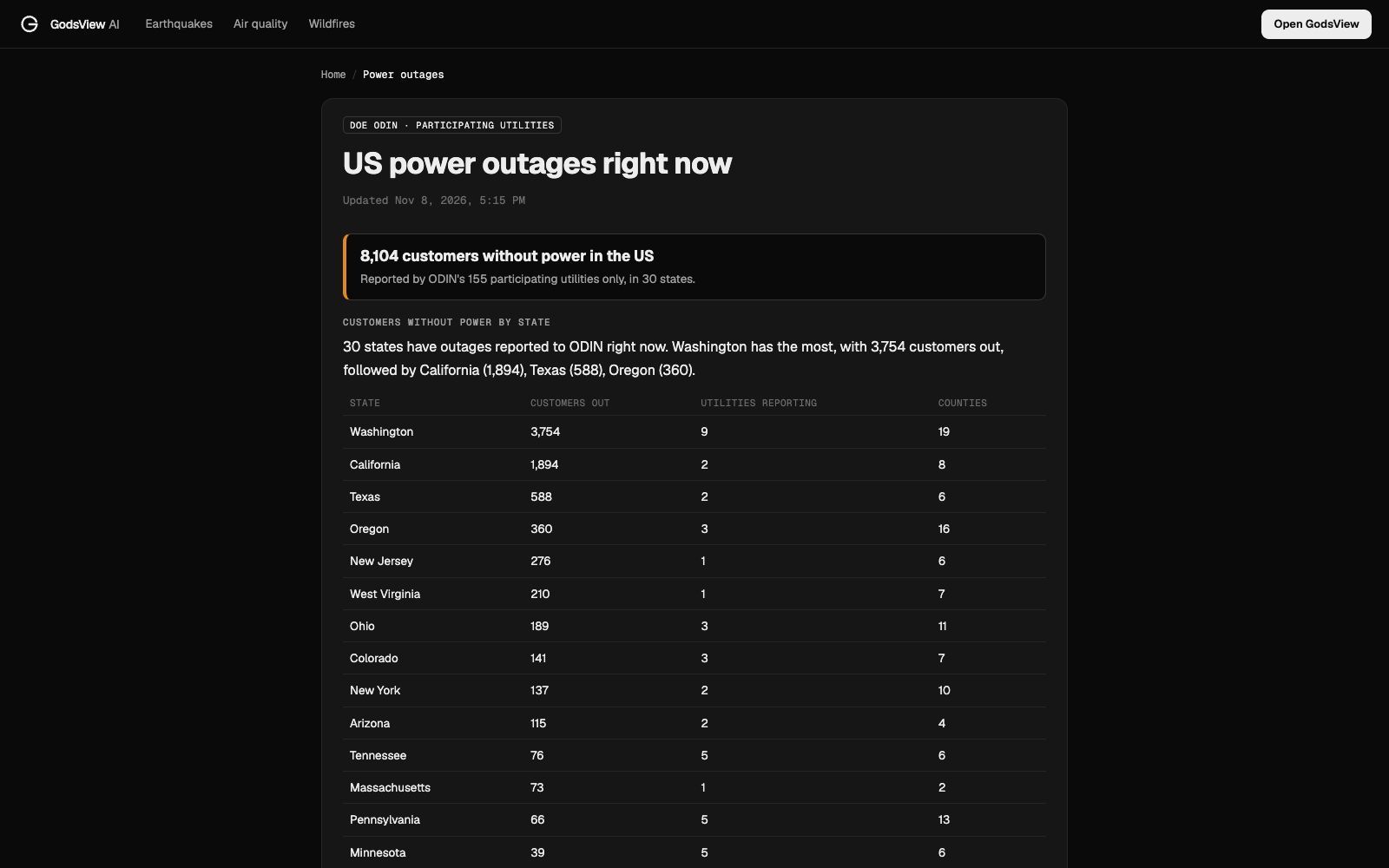
- GodsView reads the Department of Energy's ODIN feed. As of November 8, 2026, 155 utilities in 42 states publish to it, refreshed about every 5 minutes.
- Outage maps count customers (meters), not people, and report by county, so "1,147 out in Kitsap County" can mean a few streets or a whole town.
- If your outage is not on any map, report it to your utility. Your report is often what puts your street on the map in the first place.
- Keep the fridge closed: food stays safe about 4 hours in a fridge and 48 hours in a full freezer, according to the USDA.
To find out if the power is out near you, check your electric utility's outage map or app first, then a national outage map to see how big the outage is. If your home is dark but nothing shows up, report it to the utility, because small and very new outages often aren't on any map yet. In the US, GodsView's power outages page shows customers without power by state, county and utility from the Department of Energy's ODIN feed, refreshed about every 5 minutes.
I wrote this after a windy weekend in the Pacific Northwest, when the outage count around Seattle climbed past 2,600 customers in an afternoon. The steps below are the ones I use, plus the limits you should know before you trust any outage map.
See US power outages right now
Is the power out in my area or just my house?
Start with the cheapest test: look outside. If the neighbours' windows and the streetlights are dark, it's an area outage. If they're lit, check your own breaker panel or fuse box before calling anyone, since a tripped main breaker looks exactly like a blackout from inside.
Then check two maps, in this order:
- Your utility's outage map or app. This is the source. Utilities show outages on their own maps first, often with the number of customers affected on your street and a cause such as "tree on line" or "equipment failure".
- A national map. This tells you whether it's a local fault or part of something bigger, like a storm knocking out power across several counties. GodsView's US power outages page is one; it lists every state and county with outages that participating utilities report.
On November 8, 2026 at 5:15 PM Eastern, the national page read "8,104 customers without power in the US", reported by ODIN's 155 participating utilities in 30 states. Washington had the most, 3,754, followed by California with 1,894.
Where outage maps get their numbers
Every outage map is built from utility data. The difference is how that data is collected.
GodsView uses ODIN, the Outage Data Initiative Nationwide. Oak Ridge National Laboratory runs it for the US Department of Energy (ORNL ODIN). Participating utilities send standardised outage reports every few minutes, and GodsView refreshes them about every 5 minutes. Each record says which utility, which county, how many customers are out, and, when the utility fills it in, a cause and an estimated restoration time.
The catch is in the word participating. ODIN only includes utilities that choose to publish to it. Customers of any other utility, including many city-owned systems and co-ops and some large investor-owned utilities, can lose power without appearing on the page. GodsView says this on every outage page and never claims "no outages" for an area its utilities don't cover. The page also names the utilities it does cover, so you can tell at a glance whether yours is one of them.
Other national trackers, such as PowerOutage.us, collect figures from many utilities' public outage maps. They cover more utilities, and they have the same basic limit: they can only count what the utilities publish.
| Where you look | What it's best for | What it misses |
|---|---|---|
| Your utility's outage map or app | Your street, the cause, the crew status, reporting a new outage | Anything outside that utility's territory |
| GodsView power outages (ODIN) | The national and state picture, county counts, which nearby utilities report | Utilities that don't publish to ODIN, street-level detail |
| Local news and the utility's social accounts | Big storms, planned shutoffs, wildfire safety shutoffs | Small outages and exact numbers |
| Weather warnings for your city | Why the count is rising: wind, ice, storms, heat | The outage itself |
How to check outages for your city or state
The national page links to every state with a participating utility. Pick yours and you get customers out by utility and by county, the most affected city areas, and a list of the state's ODIN utilities with how many customers each serves. Power outages in Texas and California are two of the busiest.
For a city, use the city page, for example power outages in Houston or Seattle. A city page counts outages within about 40 km of the city centre and tells you:
- how many customers are out nearby and in how many county areas
- the nearest outage area, with its distance and compass direction
- the utility, the stated cause and the estimated restoration time, when the utility gives one
- which utility serves the city centre and which others report nearby
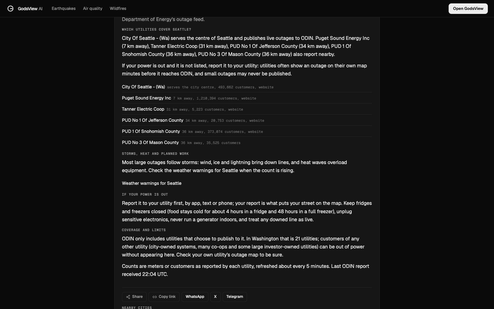
That last part matters more than it looks. If your utility isn't in the list, a quiet page tells you nothing about your street, so go straight to your utility's own map.
How to read customers out, causes and restoration times
Customers are meters, not people. One "customer" is usually one account: a house, an apartment, a shop. A count of 1,000 customers is a few thousand people, depending on the area.
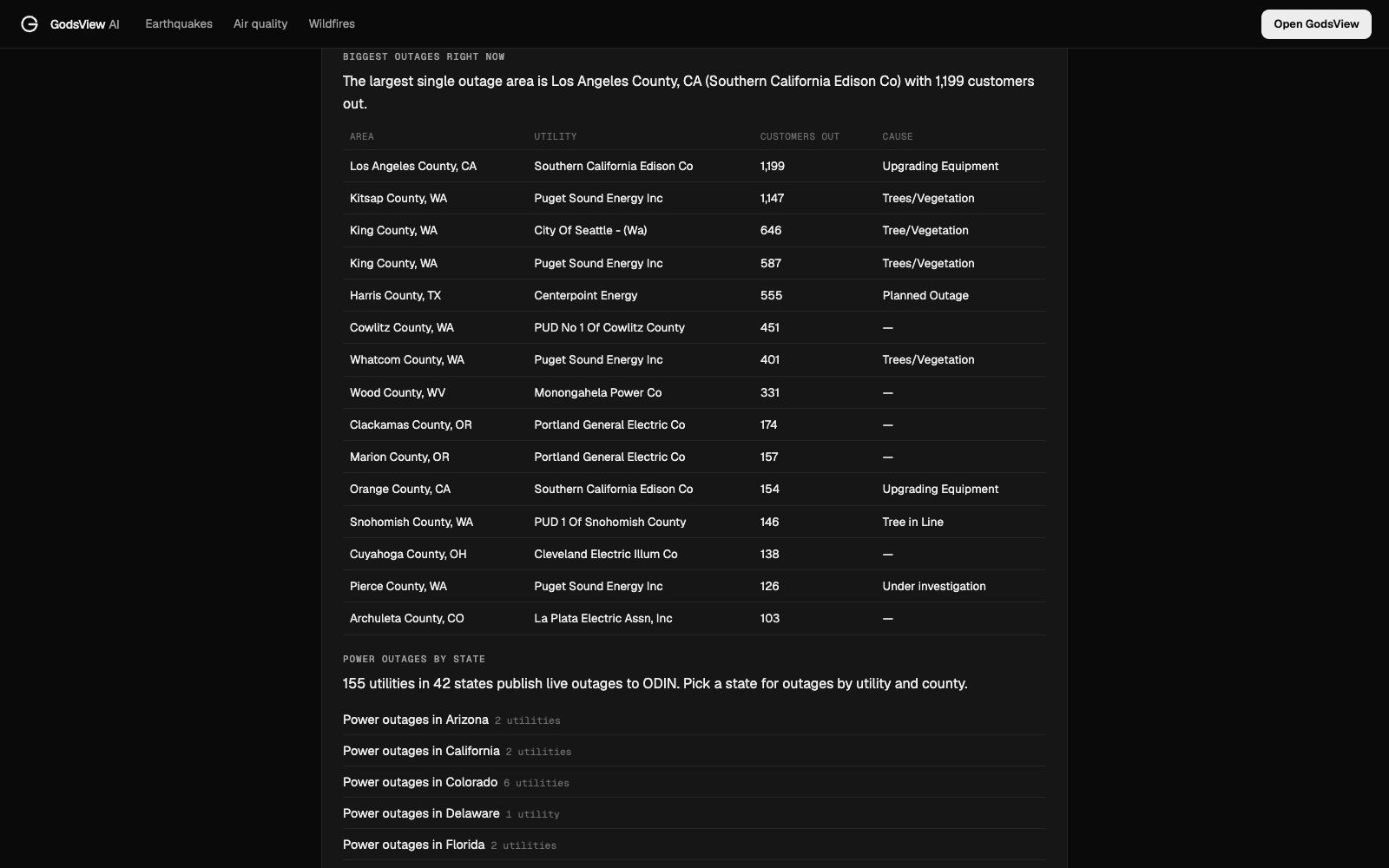
Counties are big. ODIN reports outages by county, and GodsView measures distances to the county centre. "1,147 customers out in Kitsap County, 24 km west of Seattle" doesn't mean the outage is 24 km away from you. It could be anywhere in that county.
The cause is the utility's own label. On November 8 the biggest outages listed causes such as "Trees/Vegetation", "Upgrading Equipment", "Planned Outage" and "Under investigation". Planned work shows up next to storm damage, so a large number on a calm day is often maintenance.
Restoration times are estimates. Utilities revise them as crews assess damage. After a big storm, the first estimate is often a placeholder. Treat it as "not before", not as a promise.
When will my power be back?
There's no single answer, but the pattern is predictable. Utilities restore power in order of how many people a repair brings back and how critical the load is: transmission lines and substations first, then main feeder lines, then the smaller lines that serve a few streets, and finally individual service drops to single homes. If your neighbours have power and you don't, you may be on that last list, so report it again.
For a sense of scale, the US Energy Information Administration says "U.S. electricity customers averaged five and one-half hours of power interruptions in 2022" (EIA). Most of those hours come from major events such as hurricanes and winter storms, which is why a typical blown transformer is fixed in hours while a hurricane can leave areas dark for days.
Why the power goes out: storms, heat and planned work
Most large outages follow weather. Wind and ice bring trees down on lines, lightning trips equipment, and heat waves overload transformers when everyone runs air conditioning at once. When the count near you is rising, check the weather warnings for Seattle (or your own city) to see whether a wind or winter storm warning explains it. Our guide to weather watches and warnings explains what each level means.
Other common causes:
- Planned outages for maintenance or upgrades, usually announced in advance by the utility.
- Public safety power shutoffs in wildfire-prone areas, when utilities cut power during dry, windy weather so lines can't start a fire.
- Vehicle crashes into poles, which cause short, very local outages.
- Animals in substations and on lines, a surprisingly common cause of small outages.
What to do while the power is out
- Report it to your utility by app, text or phone, even if you think others already have.
- Keep the fridge and freezer closed. The USDA says a fridge keeps food safe for about 4 hours if the door stays shut, and a full freezer holds its temperature for about 48 hours (24 hours if half full) (USDA FSIS).
- Unplug sensitive electronics so a surge when the power returns doesn't damage them. Leave one light switched on so you know when it's back.
- Never run a generator indoors or in a garage, even with the door open. Carbon monoxide from generators kills people every year; the CDC says to keep them outside and at least 20 feet from windows and doors (CDC).
- Tell your utility in advance about medical equipment. If someone at home depends on powered medical devices, many utilities keep a priority or medical-needs list; register before storm season and have a backup plan.
- Treat every downed line as live. Stay well away and call the utility or emergency services.
- Save your phone battery. Lower the brightness and close apps; you'll want it for the utility's updates.
How GodsView fits in, and what it doesn't do
GodsView is useful for the wide view: how big an outage is, which counties and utilities it touches, and whether a storm warning explains it. The power outage pages are free and need no account. Power outages are also a layer on the live map, next to weather warnings, cameras and flights; that layer is part of GodsView Plus.
It doesn't replace your utility. It can't show your street, it can't take an outage report, and it only covers utilities that publish to ODIN. GodsView alerts on My places don't include power outages either; they cover earthquakes, severe weather, floods, wildfires and unhealthy air near the places you save (see how to get disaster alerts near home). For outage notifications, sign up for your utility's text alerts.
Frequently asked questions
How do I check if there is a power outage near me?
Check your electric utility's outage map or app first. For the wider picture in the US, open the GodsView power outages page and pick your state or city to see customers out by county and utility.
Why is my outage not on the outage map?
It may be too new or too small to be published yet, or your utility may not report to the map you are using. GodsView uses the DOE ODIN feed, which only includes participating utilities. Report the outage to your utility.
How often is the GodsView outage map updated?
GodsView refreshes the ODIN data about every 5 minutes. Utilities send their reports to ODIN every few minutes.
What does "customers out" mean?
It is the number of utility accounts (meters) without power, not the number of people. One customer is usually one home or business.
How long does food last in the fridge without power?
About 4 hours in a closed fridge, and about 48 hours in a full freezer (24 hours if half full), according to the USDA.
Does GodsView cover power outages outside the US?
No. The power outage pages use the US Department of Energy ODIN feed, so they cover participating US utilities only.
Sources
- Oak Ridge National Laboratory: ODIN, Outage Data Initiative Nationwide
- EIA: U.S. electricity customers averaged five and one-half hours of power interruptions in 2022
- USDA FSIS: Keep your food safe during emergencies
- CDC: Carbon monoxide poisoning basics
Facts checked on against each provider's own site.