Explainer
Weather Watch vs Warning: What Alerts Mean and What to Do
Your phone buzzes with a "watch" one evening and a "warning" the next, and the difference decides whether you finish dinner or head for the basement. Here is what each level means in the US, Canada and Europe, and how to see the alerts for your city in one place.
Key takeaways
- A watch means the hazard is possible: be prepared. A warning means it is happening or about to: act now.
- An advisory is a lower level for conditions that are a nuisance or risky but not as dangerous as a warning, such as dense fog or light freezing rain.
- In Europe and the UK, colours replace most of these words: yellow means be aware, amber or orange means be prepared, red means take action.
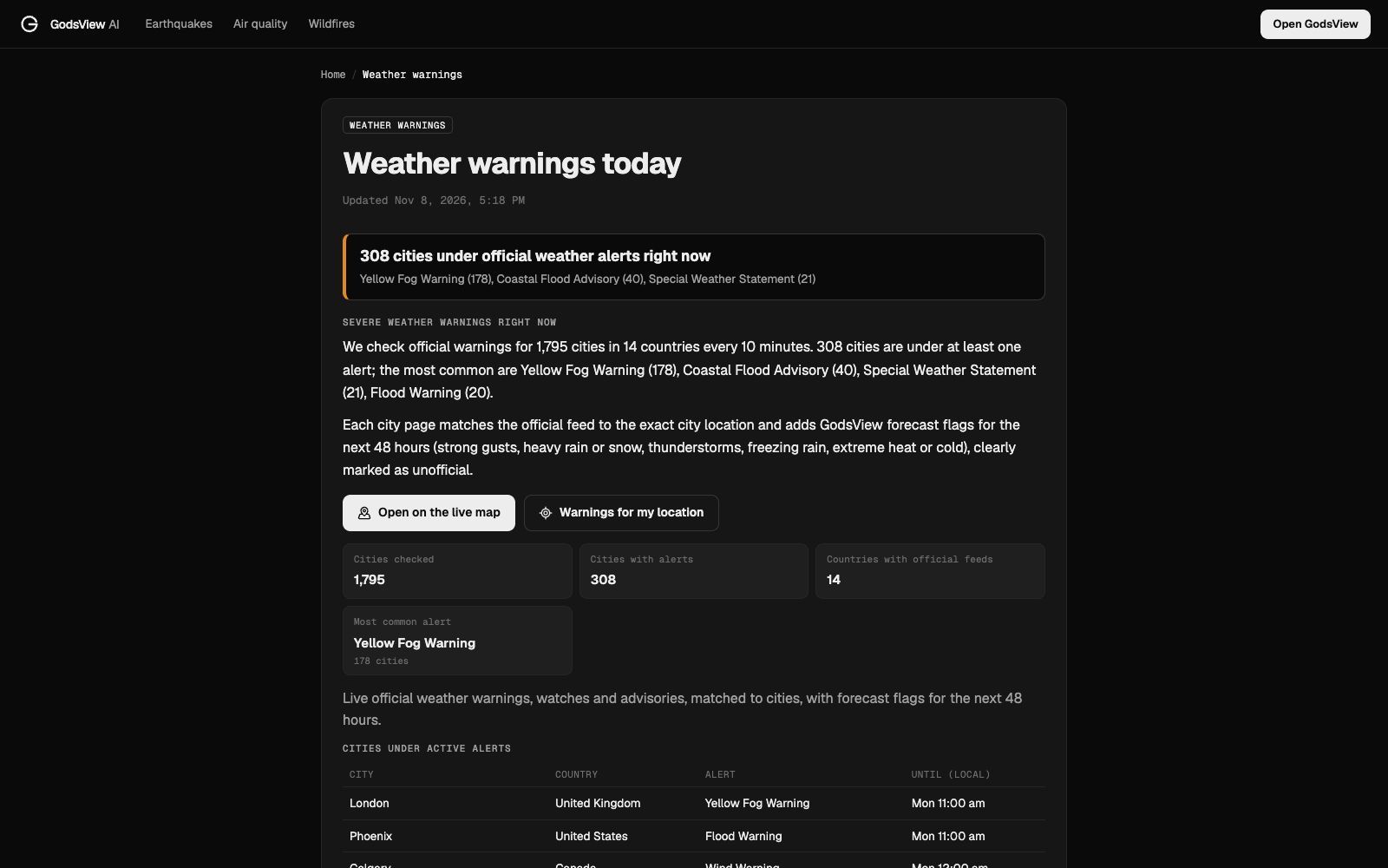
- GodsView checks official warnings for 1,795 cities in 14 countries every 10 minutes. On November 8, 2026, 308 of them were under at least one alert.
- Official alerts from your national weather service and Wireless Emergency Alerts on your phone come first; maps are for seeing the wider picture.
A weather watch means conditions are right for a hazard to develop, so be prepared. A weather warning means the hazard is happening now or is about to, so act now to protect yourself. An advisory sits below a warning: the weather is a nuisance or a risk, but less dangerous. That's how the US National Weather Service (NWS) and Environment and Climate Change Canada use the words. In Europe and the UK, colours do the same job: yellow, amber or orange, and red.
To see which alerts cover your city right now, GodsView's weather warnings page pulls the official feeds for 1,795 cities in 14 countries and refreshes them every 10 minutes.
Watch vs warning vs advisory: the short version
| Level | What it means | What to do |
|---|---|---|
| Watch | The ingredients for the hazard are in place. It's possible, but not certain, in the next hours or days. | Be prepared. Check your plan, charge your phone, know where you'd shelter. |
| Warning | The hazard is happening, imminent or very likely in your area. | Take action now to protect life and property. |
| Advisory | Less serious conditions that still cause significant inconvenience and can be risky. | Be careful: allow extra time, slow down, adjust plans. |
| Statement | Information that falls below those levels, or follow-up on an event. | Read it and keep an eye on updates. |
The NWS puts it in three words each: a watch is "Be Prepared", a warning is "Take Action", and an advisory calls for caution (NWS).
The key difference is certainty and timing. A watch is a forecast that something could happen, usually over a large area. A warning is issued when it is happening or is about to, for a smaller area, often with minutes to hours of lead time.
Tornado watch vs tornado warning
This is the pair people search most, because the gap between them is life or death.
- A tornado watch means conditions are favourable for tornadoes in and near the watch area. Watches are issued by NOAA's Storm Prediction Center, often cover parts of several states, and usually last several hours. Go about your day, but know where your safe room is and keep alerts switched on.
- A tornado warning means a tornado has been seen or weather radar indicates one. It's issued by your local NWS office for a much smaller area, often a few counties or a polygon around the storm's path. Go to shelter immediately: a basement, or an interior room on the lowest floor away from windows (NWS).
The same logic applies to severe thunderstorm watches and warnings, flood watches and flood warnings, and winter storm watches and warnings. GodsView has a live page for each common US type, listing every active alert by state, for example tornado warnings and tornado watches.
Why you can get a warning without a watch
Watches aren't always issued first. Some hazards develop too fast or too locally to forecast hours ahead:
- Flash floods can follow a single slow-moving thunderstorm, so a flash flood warning may appear with no flood watch beforehand.
- Tornadoes sometimes form outside a watch area, or from storms that didn't look dangerous an hour earlier.
- Dense fog and black ice tend to get advisories at short notice, often overnight.
So don't wait for a watch to start paying attention when the sky looks threatening. And when a watch is out, treat it as the time to get ready, because the warning, if it comes, may give you only minutes.
Warnings are also more targeted than they used to be. The NWS issues many short-fuse warnings, such as tornado, severe thunderstorm and flash flood warnings, as polygons drawn around the storm's expected path rather than whole counties. That's why your neighbour across the county line can get an alert you don't, and why GodsView matches alerts to each city's exact location.
A real example: a winter storm watch
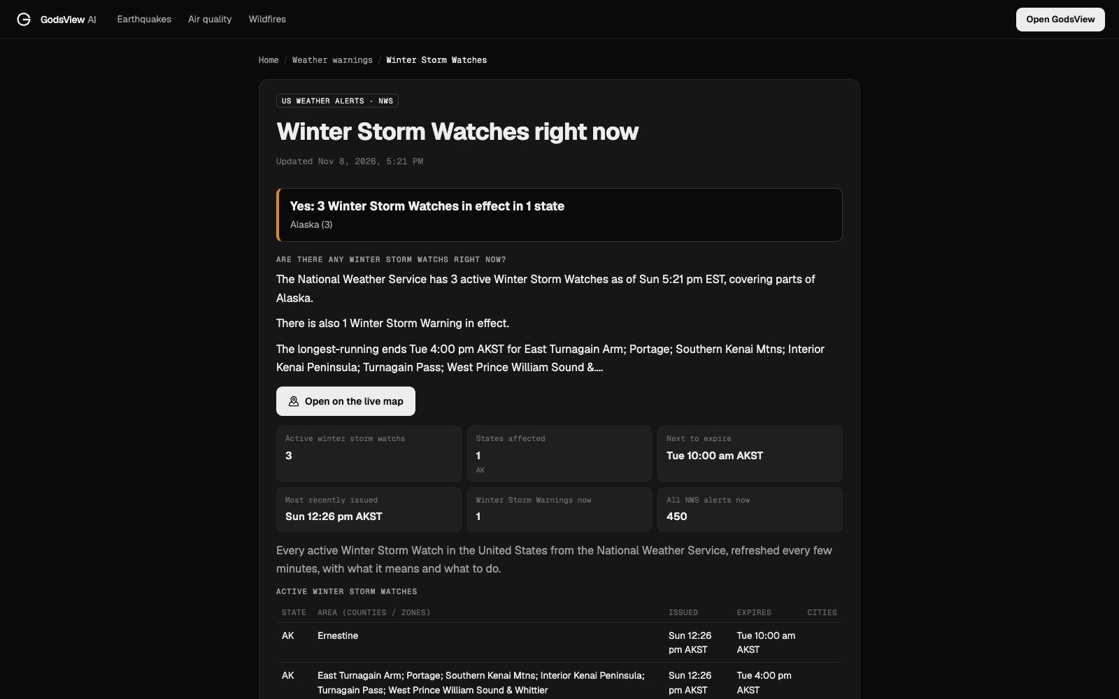
On November 8, 2026, the NWS had three Winter Storm Watches in effect, all in Alaska, plus one Winter Storm Warning. GodsView's winter storm watch page listed each one with its area, issue time and expiry, and explained what it means: significant snow, sleet or ice is possible in the next one to three days, but the timing, track or amounts are still uncertain.
That's the typical life of a winter storm alert. The watch comes first, a day or more ahead. As the storm's track firms up, the NWS upgrades parts of the watch area to a warning (heavy snow or ice expected), downgrades others to an advisory (lighter amounts) and drops the rest.
How Canada and Europe do it
Canada. Environment and Climate Change Canada (ECCC) also issues warnings, watches, advisories and special weather statements. Its alerts are based on set criteria that differ by region; a wind warning in one part of the country needs different gust speeds than in another (ECCC alert criteria). ECCC alerts also carry a colour reflecting expected impact.
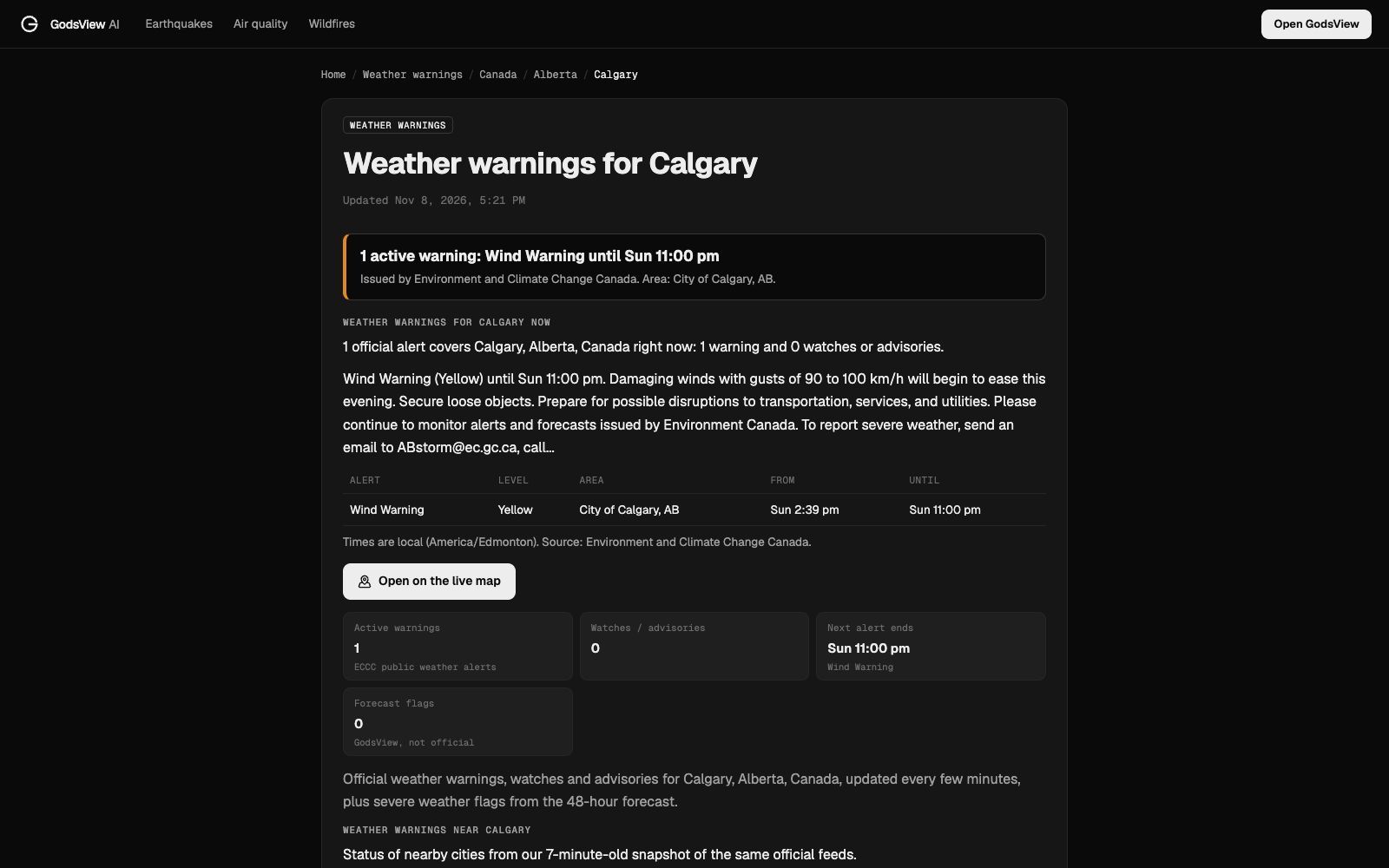
Here's what one looks like. On the afternoon of November 8, 2026, Calgary was under a yellow Wind Warning until 11 pm: "Damaging winds with gusts of 90 to 100 km/h will begin to ease this evening. Secure loose objects."
The UK and Europe. The Met Office and most European weather services use colours based on impact and likelihood (Met Office):
- Yellow: be aware. Potentially dangerous weather, but not unusual.
- Amber (orange in much of Europe): be prepared. Dangerous, unusual weather with likely damage or disruption.
- Red: take action. Very dangerous, exceptionally intense weather.
Across Europe, MeteoAlarm collects the national warnings on one map (MeteoAlarm). A yellow warning is common: on November 8, the most common alert in GodsView's city list was a Yellow Fog Warning, covering 178 cities including London.
How to check the weather warnings for your city
- Open weather warnings today. The summary at the top says how many cities are under alerts and the most common types. The table lists each city with its alert and when it ends.
- Open your city's page from the list, or by searching for it. A city page, such as Calgary, shows every active alert from the official feed, its level, the area it covers, and its start and end times in local time.
- Look at the cities nearby. City pages list the alerts for nearby cities, which helps when a warning covers the next county but not yours yet.
- Read the forecast flags separately. City pages add GodsView forecast flags for the next 48 hours (strong gusts, heavy rain or snow, thunderstorms, freezing rain, extreme heat or cold). They're clearly marked as unofficial; they're a heads-up, not a warning.
GodsView matches each official alert to the city centre's exact location. That's precise, but it means an alert for the neighbouring county won't appear on your city's page, so check the nearby list too, and the country pages for the United States and Canada.
Which countries are covered
As of November 2026, GodsView reads official feeds for 14 countries: the US (National Weather Service), Canada (ECCC), Germany (Deutscher Wetterdienst), the UK (Met Office), Norway, Sweden, Switzerland, the Netherlands and Israel through their national services, and Iceland, Slovenia, Estonia, Latvia and Ukraine through MeteoAlarm or their own services. The hub page shows each source and how many alerts it currently carries.
If your country isn't on that list, use your national weather service's own warnings page.
Getting alerts on your phone
For life-threatening warnings, rely on the official channels first:
- Wireless Emergency Alerts in the US (and Alert Ready in Canada) push the most dangerous warnings, such as tornado and flash flood warnings, to phones in the area automatically (Ready.gov).
- NOAA Weather Radio broadcasts NWS warnings around the clock and works when the power and the mobile network are down (NWS).
- Your weather service's app or a local TV station's app.
GodsView adds a wider view. Weather alerts are a free layer on the live map, next to storm tracks; weather radar and traffic cameras are there too as GodsView Plus layers. If you save a place on My places, a severe weather warning rule for US NWS warnings is switched on for it, alongside earthquakes, floods, wildfires and bad air. Saving watches and getting those alerts needs GodsView Plus or Pro; checking warnings is free. The setup is covered in how to get disaster alerts near home.
What to do at each level
- Watch: check your plan. Know where you'd shelter, charge phones and power banks, fill the car, bring in loose objects, and follow updates.
- Advisory: adjust. Leave extra time, slow down on the roads, keep children and pets out of the heat or cold.
- Warning: act. Follow the specific instructions in the warning text: shelter for tornadoes, move to higher ground for flash floods, stay off the roads in ice storms.
After a big storm, outages often follow. Our guide to the power outage map shows how to check whether the power is out near you. For hurricanes, see how to watch a hurricane live and the hurricane tracker.
One naming change to know: on March 4, 2025 the NWS renamed the Excessive Heat Watch and Warning to the Extreme Heat Watch and Warning, so older articles and apps may still use the old names (NWS).
Frequently asked questions
What is the difference between a watch and a warning?
A watch means the hazard is possible, so be prepared. A warning means it is happening or about to happen in your area, so take action now.
Which is worse, a tornado watch or a tornado warning?
A tornado warning. It means a tornado has been seen or indicated by radar near you, and you should take shelter immediately. A watch means conditions could produce tornadoes.
What is a weather advisory?
An advisory is for weather that is less serious than a warning but still causes significant inconvenience and can be risky, such as dense fog, frost or light snow and ice.
What do yellow, amber and red weather warnings mean?
Used in the UK and much of Europe: yellow means be aware, amber (orange) means be prepared for dangerous weather and disruption, and red means take action because the weather is very dangerous.
How do I see the weather warnings for my city right now?
Open weather warnings today and pick your city. GodsView checks official feeds for 1,795 cities in 14 countries every 10 minutes and shows each alert with its level, area and end time.
Are GodsView forecast flags official warnings?
No. They are flags from the 48-hour forecast, marked as unofficial. Only your national weather service issues official watches and warnings.
Sources
- NWS: Wind watches, warnings and advisories
- NWS: Tornado watch vs warning
- Environment and Climate Change Canada: Public alerting criteria
- Met Office: Weather warnings guide
- MeteoAlarm: Weather warnings for Europe
- Ready.gov: Emergency alerts
Facts checked on against each provider's own site.