Alternatives
Zoom Earth Alternatives: Live Satellite, Storm and Fire Maps
GodsView puts wildfires, storms, weather warnings, earthquakes, air quality and aurora on one free map, with flights and ships too. Here is how it compares with Zoom Earth, Windy, Ventusky, NASA Worldview, FIRMS, earth.nullschool and RainViewer, with prices as of November 2026.
Key takeaways
- GodsView is a free map of wildfires (NASA FIRMS), storms, earthquakes and official weather warnings for 1,795 cities in 14 countries, plus flights and ships that weather maps don't show.
- GodsView city pages answer "is there a fire or warning near me" without an account, and Plus ($10.99/month) adds alerts for your places.
- Zoom Earth shows geostationary satellite imagery every 10 minutes plus radar, forecasts, storm tracks and fires; Pro removes ads and extends forecasts to 10 days.
- Windy and Zoom Earth are stronger than GodsView for detailed forecasts and model data; Windy has more than 50 maps and more than 15 models.
- NASA Worldview (over 1,200 imagery products) and NASA FIRMS (fire detections within about 3 hours) are free, official sources; RainViewer and Ventusky update radar every 5 minutes.
For most people, GodsView AI is the best free Zoom Earth alternative: one map with NASA FIRMS wildfires, storms, earthquakes and official weather warnings for 1,795 cities, plus air quality, aurora, flights and ships, free in the browser and on iPhone. If you need detailed forecasts and model data, Windy or Zoom Earth itself covers that; RainViewer and Ventusky focus on radar, and NASA Worldview on raw satellite imagery.
Zoom Earth, made by Neave Interactive, is a weather map built around satellite imagery. Its app listing says live images from NOAA GOES, JMA Himawari and EUMETSAT Meteosat geostationary satellites update every 10 minutes, and HD images from NASA's Aqua and Terra update twice a day.
Prices below were checked on November 5, 2026.
Open the GodsView storm and fire map
How do the Zoom Earth alternatives compare?
| Tool | Live satellite | Storms | Wildfires | Radar | Price (as of Nov 2026) |
|---|---|---|---|---|---|
| GodsView | Plus plan | Yes, free | Yes, NASA FIRMS, free | Plus plan | Free; Plus $10.99/month |
| Zoom Earth | Every 10 min (geostationary) | Yes | Incidents and daily heat spots | Yes, with nowcast | Free with ads; Pro in-app purchase |
| Windy | Yes, 24h loops on Premium | Yes, multiple models | Fire danger layer | Yes | Free; Premium in-app purchase |
| Ventusky | Yes | Yes, with forecast cone | Yes | Every 5 min | Free; Premium $19.99/year (US App Store) |
| NASA Worldview | Geostationary every 10 min, 90 days back | Events tab | Yes | No | Free |
| NASA FIRMS | Imagery for context | No | Yes, within about 3 hours | No | Free |
| earth.nullschool | No | No | VIIRS fire layer | No | Free |
| RainViewer | Yes | Yes | No | Every 5 min, 2 min on paid | Free; Essential $19.99/year (US App Store) |
App Store prices are US prices and vary by country. GodsView is also the only one here that shows flights and ships.
Why is GodsView our pick for storms, fires and warnings?
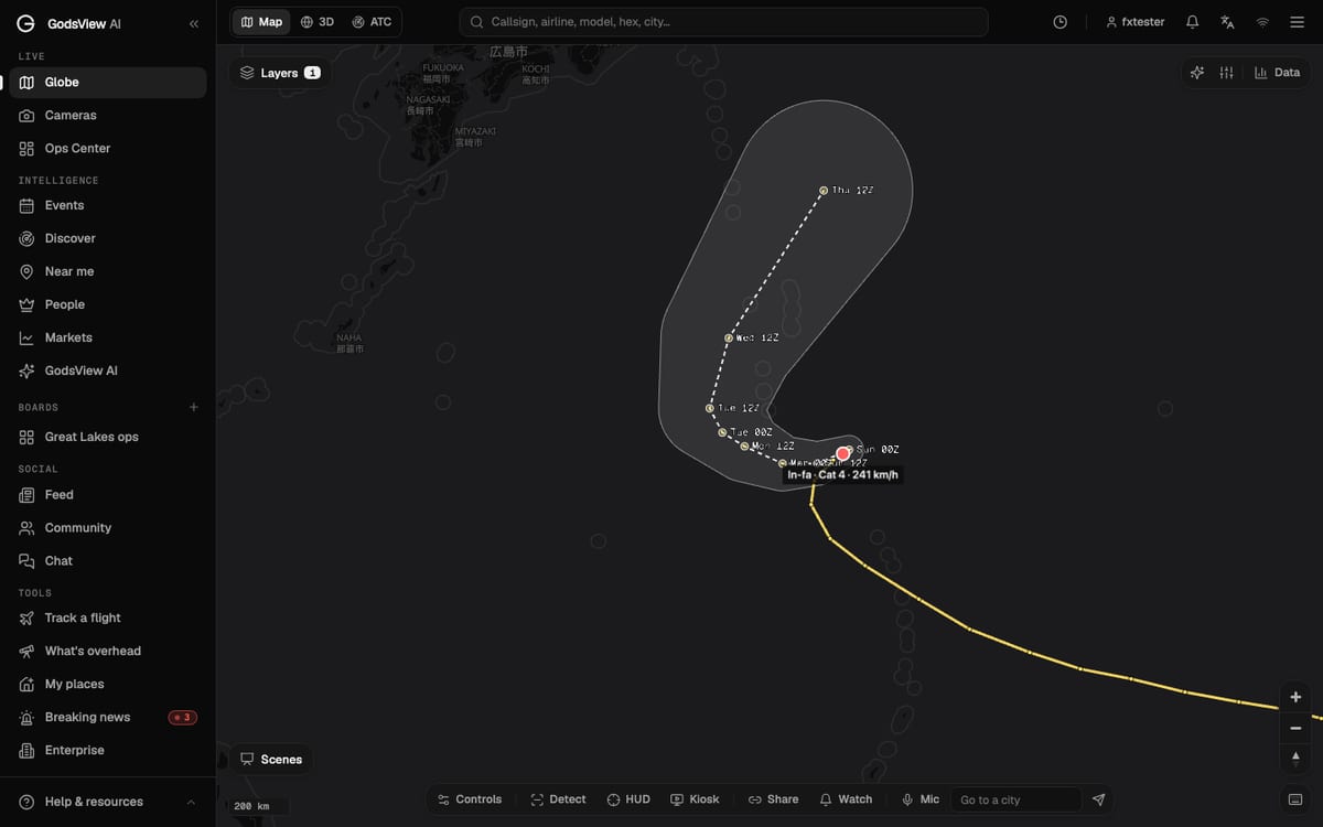
Weather maps tell you what the atmosphere is doing. GodsView tells you what's happening near the places you care about. The free map shows storms and hurricanes, NASA FIRMS wildfires, earthquakes from USGS and official weather warnings, next to flights, ships and satellites. Air quality and aurora forecasts (from NOAA SWPC) have their own city pages.
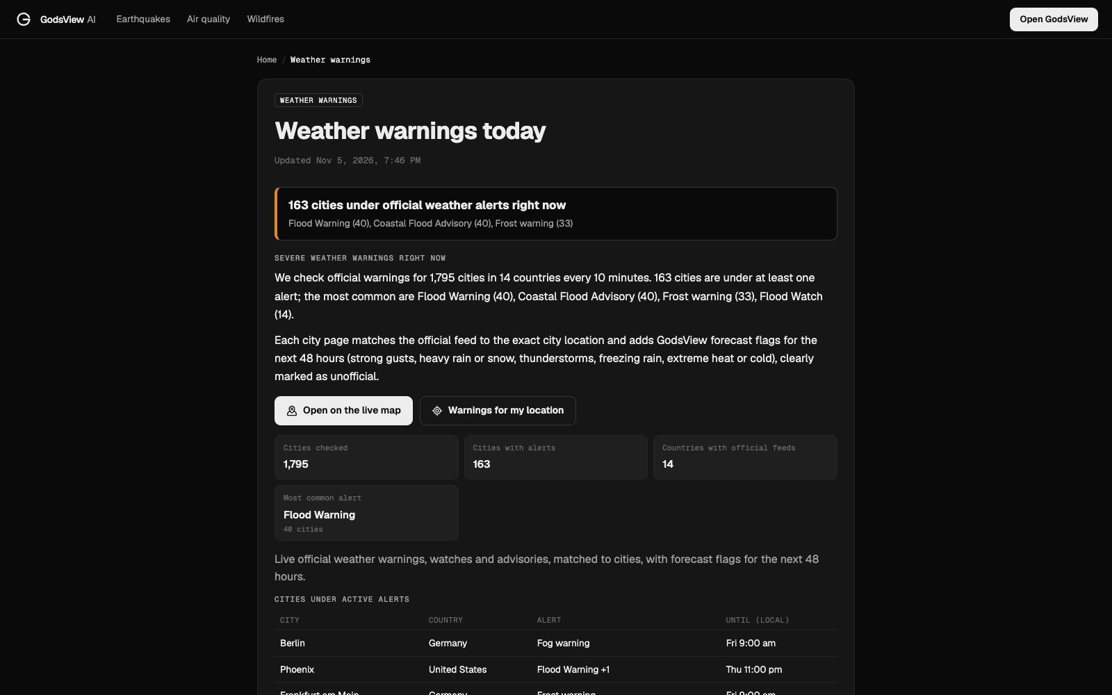
Our weather warnings page checks official warnings for 1,795 cities in 14 countries every 10 minutes. On the evening of November 5, 2026, it listed 163 cities under at least one alert. The most common were Flood Warning (40 cities), Coastal Flood Advisory (40) and Frost warning (33), with frost warnings across much of Germany, flood warnings around Phoenix and a Red Flag Warning for Santa Clarita, just north of Los Angeles.
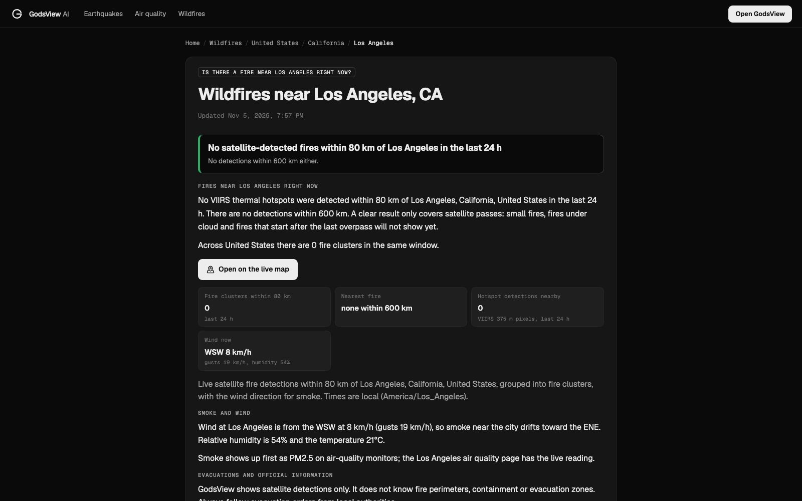
City pages answer the question most people actually have: is there a fire or a warning near me? When we checked our wildfires near Los Angeles page on the afternoon of November 5, 2026 (Los Angeles time), it showed no VIIRS hotspots within 80 km in the previous 24 hours and none within 600 km, with wind from the WSW at 8 km/h and 54% humidity. The page is clear that a clean result only covers satellite passes: small fires, fires under cloud and fires that start after the last overpass won't show yet. Pages for air quality in Delhi and the aurora forecast in Fairbanks work the same way, with no account needed.
The map itself asks most visitors for a free account (no payment), has banner ads, and live viewing pauses after 30 minutes. GodsView Plus costs $10.99 per month or $99.99 per year as of November 2026. It removes ads and the time limit and adds alerts for your places, flights and topics, plus weather radar, satellite imagery, live cameras and advanced 3D. Pro ($129.99 per month or $1,499.99 per year) adds boards, Fusion detections, an AI agent and exports. The pricing page has the full list. The free iPhone app, GodsView AI, uses the same account and plan (details); Android is in testing.
What it doesn't do: GodsView has no forecast models, no model comparison and no wind animation. Windy and Zoom Earth are stronger for detailed weather forecasting and model data.
Check fires and warnings near you
What does Zoom Earth do well, and where does it stop?
Zoom Earth opens straight onto moving clouds and storms. Its tropical tracks use data from NHC, JTWC, NRL and IBTrACS, and its active fire incidents come from NIFC, CIFFC, CEMS, EFFIS, GDACS and other official sources, according to the Zoom Earth site.
Two limits matter. Its heat spots layer isn't live: the site warns detections are "updated daily" and "delayed by many hours." And the free tier shortens forecasts and radar nowcasts; Zoom Earth Pro unlocks 10-day forecast maps, a 1-hour radar nowcast and no ads. The US App Store lists Zoom Earth Pro in-app purchases at $1.99 and $11.99.
Is Windy better than Zoom Earth for forecasts?
Yes. Windy's App Store listing describes more than 50 weather maps and more than 15 weather models, including ECMWF, GFS, ICON and HRRR, and you can compare models side by side. Its hurricane tracker shows, in its words, "all the forecasts available for a storm." It also has webcams and a fire danger layer.
Windy Premium adds a 15-day hourly outlook, 24-hour radar and satellite loops and 1-year archives. The US App Store lists Premium purchases between $2.99 and $29.99, so check your country's store.
Which weather map has no ads? Ventusky
Ventusky's App Store listing says it combines more than 20 forecast models with radar, lightning, satellite imagery and webcams, and that the app is "completely free of ads or tracking scripts." Its release notes describe radar every 5 minutes, a hurricane tracker with a forecast cone and global fire tracking. On the US App Store, Premium costs $4.99 per month or $19.99 per year, and Premium+ $5.99 per month or $24.99 per year.
Where can you get raw satellite imagery? NASA Worldview
NASA Worldview runs on NASA's GIBS service, which also supplies Zoom Earth's HD imagery. NASA says you can browse, compare, animate and download over 1,200 satellite data products, many within hours of being acquired. Geostationary imagery is there in 10-minute steps for the last 90 days, and an Events tab lists wildfires, tropical storms and volcanic eruptions. It's free (an Earthdata Login is needed for full use), but it's a science tool with no radar and no forecast.
Where do wildfire detections come from? NASA FIRMS
NASA FIRMS publishes active fire detections from the MODIS and VIIRS satellites. NASA says global data arrives within 3 hours of a satellite pass, with some US and Canada detections available in real time. Email alerts for an area and downloads are free. GodsView, Zoom Earth and earth.nullschool all show FIRMS detections in some form; our FIRMS explainer covers how to read hotspots.
Which tool shows wind and ocean currents? earth.nullschool.net
earth.nullschool.net, built by Cameron Beccario, animates wind, temperature, ocean currents, waves and air chemistry on a globe. Its about page says weather data comes from NOAA's GFS model and updates every three hours, ocean currents every day. It has a VIIRS fire layer but no cloud imagery, radar or storm tracks.
Which app is built for rain radar? RainViewer
RainViewer's App Store listing says radar updates every 5 minutes as standard, with a 2-minute option on paid plans. The free tier includes live radar, a 30-minute nowcast and a 5-day forecast, with ads. On the US App Store, Essential costs $19.99 per year and adds a 2-hour nowcast and rainfall totals; Pro costs $39.99 per year and adds 48-hour radar playback. It doesn't cover fires.
Which Zoom Earth alternative should you pick?
- You want to know about fires, storms, quakes and warnings near you: GodsView, with the live wildfire map, the live earthquake map and volcanoes on the same globe, and flights and ships alongside.
- You want alerts for your home or other places: GodsView Plus, at $10.99 per month.
- You plan outdoor trips, sailing or flying around detailed forecasts: Windy.
- You want the next hour of rain: RainViewer or Ventusky.
- You want official satellite imagery to study or download: NASA Worldview.
- You want raw fire detections as data: NASA FIRMS.
Why is no weather or fire map truly live?
Geostationary images arrive about every 10 minutes, and polar-orbiting satellites such as Aqua, Terra and VIIRS pass over one place only a few times a day. Clouds hide fires, and heat spots can come from industrial sites or farm burning. Zoom Earth itself warns that its heat spots aren't for protecting life or property. How satellite tracking works explains why. Radar has gaps too: large parts of Africa, South America and the oceans have little or none.
None of these maps replaces official warnings. For evacuations and safety decisions, follow your national weather service and local emergency agencies. See how to get disaster alerts near home and how to watch a hurricane live; GodsView's methodology page lists its data sources.
Frequently asked questions
What is the best free alternative to Zoom Earth?
For most people it's GodsView, which shows NASA FIRMS wildfires, storms, earthquakes and official weather warnings on one free map, with flights and ships too. For detailed forecasts and model comparison, Windy's free tier is the stronger choice. NASA Worldview is the free source of raw satellite imagery.
Is there a map that shows fires and weather warnings near me?
Yes, GodsView has city pages such as wildfires near Los Angeles and a weather warnings page covering 1,795 cities in 14 countries. They work without an account. GodsView Plus adds alerts for your places.
Is Windy better than Zoom Earth?
For forecasting, yes: Windy has more models, model comparison and longer outlooks. Zoom Earth is simpler and centred on live satellite imagery. Many people use both.
How often does Zoom Earth update satellite images?
Every 10 minutes for geostationary images from GOES, Himawari and Meteosat, according to its App Store listing. HD images from NASA's Aqua and Terra update twice a day, and the heat spots layer for fires updates daily with a delay of many hours.
What is the most real-time wildfire map?
NASA FIRMS is the main source, delivering global fire detections within about 3 hours of a satellite pass and some US and Canada detections in real time. GodsView, Zoom Earth and earth.nullschool all show FIRMS data. Our FIRMS explainer shows how to read it.
Does GodsView have weather radar and satellite imagery?
Yes, on the Plus plan, which costs $10.99 per month or $99.99 per year as of November 2026. The free map has storms, NASA FIRMS wildfires, earthquakes and weather warnings, but no forecast models.
Sources
- Zoom Earth — about and data sources
- Zoom Earth — App Store listing (US)
- Windy.com — App Store listing (US)
- Ventusky — App Store listing (US)
- NASA Earthdata — Worldview
- NASA Earthdata — FIRMS
- earth.nullschool.net — about
- RainViewer — App Store listing (US)
Facts checked on against each provider's own site.