How-to
Free Live Flight Tracker: How to Track Any Aircraft Live
You do not need a subscription to see where a plane is right now. Here is what the free tier of a live flight tracker gives you, what it leaves out, and three practical ways to find any aircraft on the map.
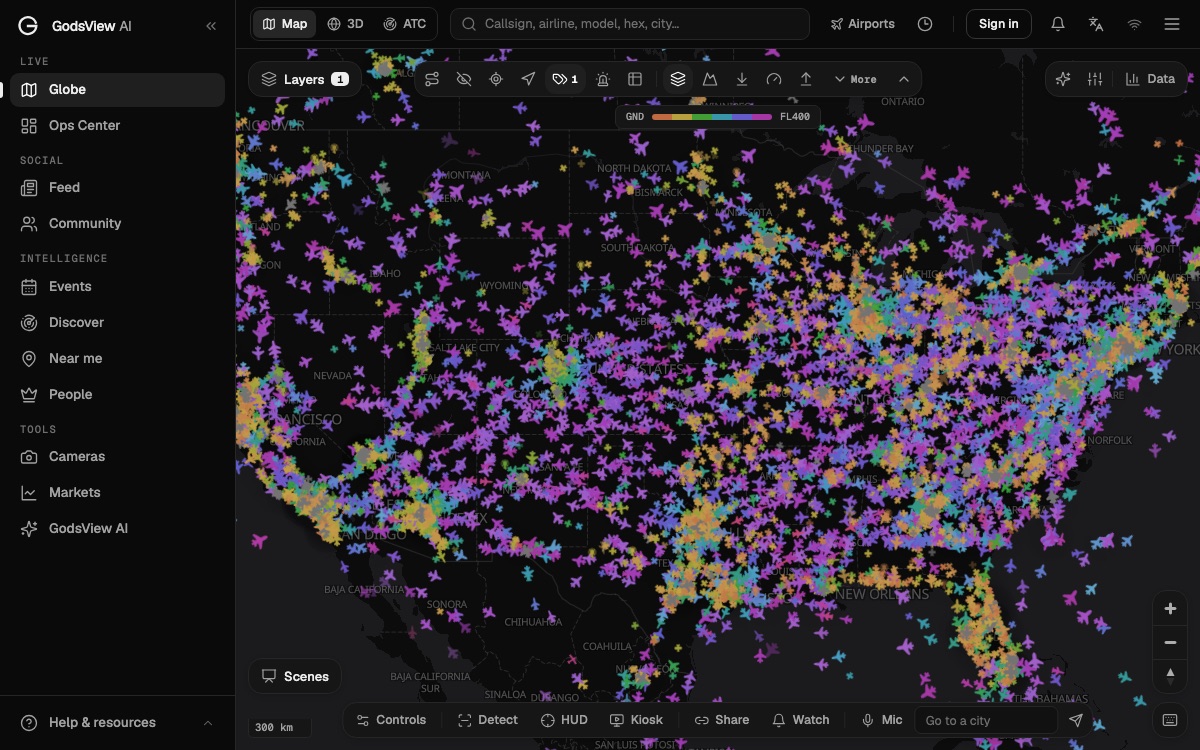
Key takeaways
- A free live flight tracker shows an aircraft's position, callsign, altitude, speed and usually its registration and type. That covers most everyday questions.
- Paid tiers mostly add alerts, longer history, extra layers and no ads. They do not make the underlying ADS-B data much better.
- Positions come from ADS-B broadcasts heard by volunteer receivers, plus MLAT, satellite ADS-B and, on some sites, government data feeds.
- Some aircraft are hidden on purpose: the FAA LADD and PIA programs, sensitive government missions, and aircraft that do not have to carry ADS-B Out.
- Track by flight number when you have a ticket, by registration or hex code when you care about one airframe, and from the map when you only know where it is.
You can track almost any aircraft live for free. Open a live flight map, search for the flight number, callsign, registration or hex code, and click the plane. A free flight tracker will show where it is, how high and fast it is flying, and who operates it. On GodsView the live flight tracker, the flight status page and the 3D globe all do this without payment.
What the free tier does not do is watch the flight for you. Alerts, long history and some extra layers sit behind a paywall on most sites. This guide is the practical version: what you get for nothing, where the dots on the map come from, why some aircraft never appear, and the exact steps to find a plane three different ways.
If you want the theory behind the radio signals, read how ADS-B flight tracking works. If you are choosing between apps, read Flightradar24 alternatives. This page assumes you just want to find a plane now.
Open the free live flight tracker
What a free flight tracker shows you
Every mainstream live flight tracker is built on the same core data, and most of it is free to view. When you click an aircraft, you should expect these fields.
| Field | Example | Where it comes from | Free on most trackers? |
|---|---|---|---|
| Position on the map | A plane icon over New Jersey | The aircraft's own GPS, broadcast by ADS-B | Yes |
| Callsign | BAW117, UAL135 | Typed in by the crew, broadcast by ADS-B | Yes |
| Altitude and vertical rate | 34,000 ft, descending | Broadcast by ADS-B | Yes |
| Ground speed and track | 480 kt heading east | Broadcast by ADS-B | Yes |
| Hex code (ICAO 24-bit address) | A061D9 | Programmed into the transponder | Yes |
| Registration and type | N-number, B738 | Looked up from the hex code in a database | Usually |
| Route (from and to) | ZRH to EWR | Matched from schedules or past flights | Usually, sometimes estimated |
| Gate, delay, terminal | Gate C71, 20 min late | Airline and airport schedule data | Varies |
| Weeks or months of history | Every flight of one aircraft | The tracker's own archive | Mostly paid |
| Alerts | Takeoff, landing, emergency | The tracker watching for you | Mostly paid |
The top half of that table is the live broadcast, and it costs the tracker very little to show. The bottom half needs schedule data, storage or servers that run while you are not looking. That is where paid plans come in.
Free vs paid: what the paid tiers add
On the large consumer trackers, the live map is free and the paid plans add extras around it.
Flightradar24 has a free tier with ads and limits on history and session length, and paid Silver, Gold and Business plans. We keep the current prices and limits in is Flightradar24 free? so they live in one place.
FlightAware lets you track for free and sells premium subscriptions. Its premium page lists the main paid features as alerts when a flight is delayed or cancelled, historical flight data going back 3, 5 or 8 months depending on the plan, and saved airports and aircraft (FlightAware).
GodsView keeps the live map, flight tracking, the What's overhead page and the city pages free. The free tier shows banner ads and pauses live viewing after 30 minutes; you reload to continue. GodsView Plus costs $10.99 a month or $99.99 a year as of November 2026 and adds alerts for flights you follow, the military aircraft layer, flight replay, no ads and no time limit. The pricing page has the full list.
The pattern is the same everywhere. You pay for the tracker to remember things and to tell you things. You do not pay for a more accurate dot, because every site is reading broadcasts from the same aircraft.
Where live flight data comes from
A flight tracker is only as good as its sources. Most use several and blend them.
| Source | How it works | Strengths | Gaps |
|---|---|---|---|
| ADS-B | The aircraft broadcasts its GPS position, altitude and speed; volunteer receivers on the ground pick it up | Precise, fast, free to receive | Needs a receiver within radio range; not every aircraft must carry it |
| MLAT (multilateration) | Several receivers time an older Mode S signal and calculate where it came from | Places aircraft that do not send a position | Needs at least several receivers in range; less smooth |
| Satellite ADS-B | Receivers on satellites hear the same broadcasts over oceans and remote land | Covers areas with no ground receivers | Sold commercially, so mostly on paid or professional products |
| Government data feeds | Radar and flight plan data from air navigation service providers, such as the FAA's SWIM service | Fills in flights that are not heard directly | Subject to the provider's rules, including the LADD block list |
The FAA describes ADS-B Out as broadcasting an aircraft's GPS location, altitude, ground speed and other data to ground stations and other aircraft "once per second" (FAA). Anyone with a cheap receiver can hear those messages, which is why community networks exist. GodsView's aircraft layer reads OpenSky Network first and falls back to adsb.lol and adsb.fi, all of which are built from those community receivers. The methodology page lists every source.
Who has to broadcast depends on the country. In the United States, ADS-B Out has been required since January 1, 2020 in Class A, B and C airspace, within 30 nautical miles of the major airports listed in the rule, up to 10,000 ft, and in most Class E airspace at and above 10,000 ft (14 CFR 91.225). In Europe, the mandate applied to aircraft with a maximum take-off mass above 5,700 kg or a maximum cruising speed above 250 knots (SKYbrary). Airliners and business jets broadcast almost everywhere. Small planes and helicopters are the patchy part.
How live is "live"?
There are three delays between the aircraft and your screen.
- The broadcast. About once per second, according to the FAA. This part is close to instant.
- The network. Receivers forward messages to a server, which merges them. Usually seconds.
- Your tracker. The site or app asks for new positions on its own schedule. GodsView's aircraft layer refreshes about every 10 seconds, and the flight status page updates every 20 seconds and tells you how old the last position is.
So a free tracker is normally a few seconds to a few tens of seconds behind the real aircraft. Between updates, many maps slide the icon forward along its last heading, which is why a plane sometimes jumps when a fresh report arrives.
Older positions are a different story. When a plane flies out of receiver range, over an ocean or a desert, the last known position stays on screen and starts to age. Always check the "last seen" or position-age field before you assume the dot is where the plane is now. Some trackers also draw estimated positions for aircraft out of coverage; treat those as guesses.
Why some aircraft are hidden or missing
A free flight tracker can't show what it never receives, and it may not show what it is asked to hide. These are the common reasons.
- LADD. The FAA's Limiting Aircraft Data Displayed program lets owners have their flight data filtered from the FAA's SWIM feed or from public display by participating sites. Vendors who take FAA SWIM data are bound by an agreement to filter LADD aircraft (FAA LADD).
- PIA. The Privacy ICAO Address program gives eligible US aircraft a temporary hex code that is not linked to the owner in the public registry. The FAA notes that LADD does not affect the ADS-B broadcast itself, while PIA is meant to stop an aircraft being "quickly and easily identified" by commercial receivers (FAA PIA). You see a position, but no name.
- Sensitive missions. US rules let the FAA authorize aircraft on national defense, homeland security, intelligence or law enforcement missions to stop transmitting when broadcasting would compromise the mission (14 CFR 91.225(f)).
- No ADS-B Out required. Aircraft flying outside the mandated airspace may not carry it, and aircraft certificated without an engine-driven electrical system, such as gliders and balloons, are exempt from much of the rule.
- Too low or too remote. Radio needs line of sight. A helicopter at 500 ft between hills, or a plane on the ground at a small airfield, can be out of range of every receiver.
Some sites also filter military aircraft or hide aircraft by request. Community networks such as adsb.lol publish what their receivers hear, which is why a military jet may appear on one tracker and not another. Our military aircraft tracking explainer covers that in detail, and how to track helicopters live covers the low-altitude problem.
Method 1: track a flight by flight number
Use this when you have a ticket, a booking email or an arrivals board.
- Open Track a flight. It works in the browser without an account.
- Type the flight number as printed, for example BA117 or EK203. You do not need to convert it. The page maps the two-letter airline code to the airline's three-letter ICAO code and looks for the matching callsign in the live data.
- Open the result. You get the route, departure and arrival times, a progress bar, altitude, speed, distance to go and an estimated landing time when the flight is airborne. Where schedule data is available, it adds gates and delays.
- Share the link. Each flight has its own URL, so you can send it to the person picking someone up.
- Tap Watch on the live map to jump to the aircraft on the globe.
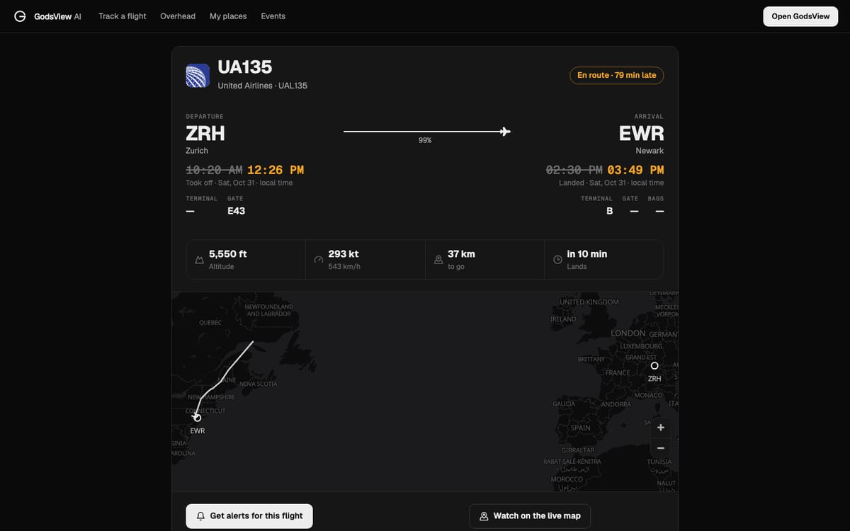
If the search comes back empty, the most common reason is that the airline flies under a callsign that does not match the ticket number. Our explainer on what a flight call sign is shows why that happens and how to find the right one.
Method 2: track an aircraft by registration or hex code
Use this when you care about one airframe: a family member's charter, an aircraft you photographed, or the plane that will operate your next flight.
- Find the registration. It is painted on the fuselage and starts with a country prefix, such as N for the United States or G for the United Kingdom.
- If you want the hex code, look the registration up. For US aircraft, the FAA registry shows the Mode S code in octal and hexadecimal.
- Open the globe or the live flight tracker. The free map asks you to sign in with a free account, with no payment.
- Type the registration or the six-character hex code into the search box. The same box also takes callsigns, airline names, aircraft types, airports and cities.
- Click the result. The data panel shows callsign, hex, registration, type, altitude and speed.
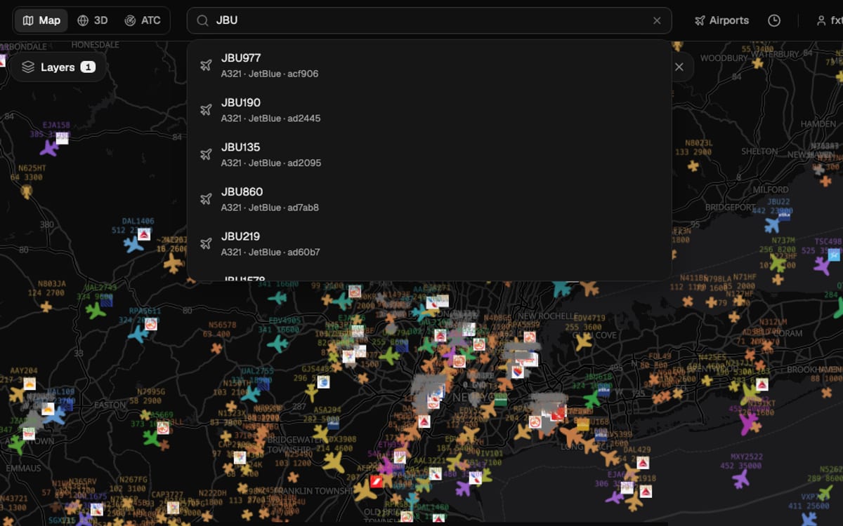
Hex is the most reliable search, because it comes straight from the transponder. Callsigns are typed by crews, and registrations depend on databases. If an aircraft on the map has no name at all, the hex code is often the only handle you have.
Method 3: track from the map when you don't know the flight
Sometimes you only know where the plane is: over your house, on approach to an airport, or circling somewhere you can hear it.
- Over you. What's overhead uses your location and lists every aircraft within 60 km, closest first, with the direction to look and how high above the horizon it is.
- Over a city. City pages such as planes over New York City count aircraft within 25 km and 60 km, and call out helicopters, military aircraft, low flyers and anything circling.
- At an airport. Hub pages such as JFK open the map on a box around the field, with the aircraft currently in that box listed below.
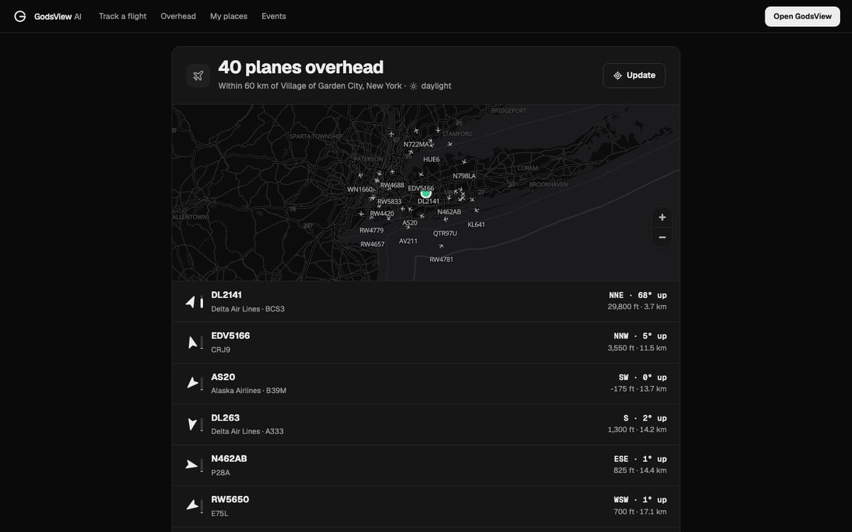
Once you have found the aircraft, click it, note the callsign or hex code, and you can follow it from there. The guide what is flying over my house goes deeper on matching the plane in the sky to the one on screen.
Getting the most out of a free tracker
A few habits make a free flight tracker much more useful.
- Check the time. Note the position age, and write times in UTC if you share a screenshot. A plane that was last seen four minutes ago has moved about 30 nautical miles at a typical cruise speed.
- Search hex when names fail. Callsigns change from flight to flight. The hex code stays with the airframe.
- Use the airline for travel decisions. A tracker shows where the aircraft is. Gates, boarding and connections come from the airline and the airport.
- Read squawk codes carefully. 7700, 7600 and 7500 have specific meanings, and short flashes are often mistakes. See what squawk 7700 means.
- Expect gaps over water. A frozen dot over the ocean is usually lost coverage, not a problem with the flight.
If you do end up wanting alerts, compare what each paid plan gives for its price. You are paying for convenience, not for more of the sky.
Why can't I find the aircraft?
Run through this list in order before assuming something is wrong.
- Is it airborne yet? Aircraft at the gate often don't show until a nearby receiver hears them taxi.
- Did you search the right identifier? Try the flight number on /flight, then the ICAO callsign, then the registration or hex.
- Is it in coverage? Remote areas and oceans have gaps. Wait for it to come back into range.
- Is it filtered? LADD, PIA and sensitive missions are covered above.
- Is it a different kind of aircraft? Military jets, police helicopters and some private aircraft may not broadcast at all.
For the full background on identifiers, airport codes and alerts, the older guide how to track a flight covers each one in more depth.
Frequently asked questions
Is there a completely free live flight tracker?
Yes. Several trackers show live aircraft for free, with ads. On GodsView, the live flight tracker, the flight status page and What's overhead are free; the live map needs a free account and pauses after 30 minutes of continuous viewing.
How do I track an aircraft live by flight number?
Type the number from your ticket, such as BA117, into Track a flight. The page converts it to the airline's ICAO callsign and finds the aircraft in the live data, with route, altitude, speed and landing time.
How accurate is a free flight tracker?
The position comes from the aircraft's own GPS, broadcast about once per second, so it is precise. The tracker adds a delay of seconds to tens of seconds, depending on how often it refreshes. Over oceans and remote land, positions can be minutes old.
Why can I not see some private jets?
Owners can ask the FAA to filter their aircraft from public displays through LADD, or fly with a temporary privacy hex code through PIA. Some aircraft are also too low or too remote for receivers to hear.
What do paid flight tracker plans add?
Mainly alerts, longer flight history, extra map layers and no ads. The live positions themselves are the same broadcasts the free tier shows.
Can I track a plane without an app?
Yes. GodsView runs in the browser on a phone or computer. There are also iPhone and Android apps if you prefer one.
Sources
- FAA: Automatic Dependent Surveillance-Broadcast (ADS-B)
- 14 CFR 91.225: ADS-B Out equipment and use
- FAA: Limiting Aircraft Data Displayed (LADD)
- FAA: ADS-B Privacy ICAO Address (PIA) program
- SKYbrary: Regulation 1028/2014, surveillance performance and interoperability (ADS-B Out thresholds)
- FAA aircraft registry inquiry
- FlightAware: Premium subscriptions
Facts checked on against each provider's own site.