Explainer
Why Do Earthquakes Happen? Faults, Plates and Magnitude
The ground under your feet is moving all the time, just very slowly. Earthquakes are what happens when that slow movement gets stuck and then lets go. Here is how that works, where it happens most, how scientists measure it, and what they can and cannot tell you in advance.
Key takeaways
- Earthquakes happen when rock on two sides of a fault, locked together by friction, suddenly slips after years of built-up strain. That sudden slip sends out seismic waves.
- Most earthquakes occur where tectonic plates meet. The Pacific Ring of Fire produces about 81% of the world's largest earthquakes, and the Alpide belt about 17%.
- Magnitude measures the size of the earthquake itself. Each whole step on the moment magnitude scale releases about 32 times more energy.
- Intensity measures shaking at one place. The Modified Mercalli scale runs from I (not felt) to X and above, and it changes with distance, depth and soil.
- No scientist has ever predicted a major earthquake. Long-term forecasts, aftershock forecasts and early warning systems such as ShakeAlert are what exist today.
Earthquakes happen because the Earth's outer shell is broken into tectonic plates that keep moving a few centimetres a year. Where plates or blocks of rock meet along a fault, friction locks them in place while strain builds up; when the strain beats the friction, the rock slips suddenly and the stored energy shoots out as seismic waves, which is the shaking you feel.
Every earthquake, from a tremor nobody notices to the 1960 magnitude 9.5 in Chile, follows that same basic pattern. What changes is how big the slipping patch of fault is, how far it moves, and how deep it sits. The rest of this guide walks through each piece.
See earthquakes happening today
How earthquakes are formed: plates, faults and stuck rock
The Earth's lithosphere, the crust plus the rigid top of the mantle, is split into a handful of very large plates and many smaller ones. They drift on hotter, softer rock beneath, at roughly the speed your fingernails grow.
Plates don't slide past each other smoothly. Their edges are rough and pressed together, so most of the time they stay stuck. The plates keep moving deeper down, though, so the rock near the boundary bends and stores energy like a flexed ruler.
A fault is a crack in the crust where blocks of rock have moved relative to each other. Faults can be hundreds of kilometres long, like the San Andreas in California, or only a few metres. Most earthquakes happen on faults that already exist, because a broken surface is the weakest place for the rock to give way.
Elastic rebound: why the slip is sudden
The idea that explains the sudden snap is called elastic rebound. Harry Fielding Reid, a geologist at Johns Hopkins University, worked it out after the 1906 San Francisco earthquake. He compared survey measurements taken across the San Andreas Fault over the decades before the quake and found the ground had been slowly bending on either side of the locked fault. In 1906 it broke and the two sides jumped several metres past each other, springing back toward an unstrained shape.
The steps are simple:
- The plates keep moving, but the fault is locked.
- Rock near the fault bends, storing elastic strain energy.
- Stress eventually exceeds the friction holding the fault.
- The fault slips in seconds to minutes, and the rock rebounds.
- Energy radiates out as seismic waves, and the cycle starts again.
GPS stations now measure that slow bending directly, which is how scientists know which faults are loading up. Knowing a fault is loaded is not the same as knowing when it will break, which comes up again below.
The three main fault types
Faults are named by which way the rock moves. The kind of plate boundary decides which type dominates.
| Fault type | How the rock moves | Typical setting | Example |
|---|---|---|---|
| Normal | Crust stretches; the upper block slides down | Spreading zones and rifts | Basin and Range, Nevada and Utah; East African Rift |
| Reverse (thrust) | Crust is squeezed; the upper block is pushed up | Subduction zones and collision zones | 2011 Tōhoku, Japan; Himalayas |
| Strike-slip | Blocks slide sideways past each other | Transform boundaries | San Andreas Fault; North Anatolian Fault, Turkey |
The very largest earthquakes, magnitude 9 and above, happen on megathrusts: huge, gently sloping reverse faults where one plate dives under another in a subduction zone. Because the sea floor can lift or drop suddenly during these quakes, they're also the main cause of ocean-wide tsunamis. Our guide to what a tsunami is explains how that works.
How deep earthquakes are, and why depth matters
The point inside the Earth where the slip starts is the hypocenter (or focus). The spot on the surface directly above it is the epicenter, which is what you see plotted on a map. The USGS groups quakes into three depth bands:
- Shallow: 0 to 70 km. Most earthquakes are here, and they do the most damage.
- Intermediate: 70 to 300 km.
- Deep: 300 to 700 km. These happen only inside slabs of plate sinking into the mantle.
Depth changes what people feel. A shallow quake puts the shaking close to the surface, so it's strong near the epicenter. A deep quake of the same magnitude spreads its energy over a wider area and shakes the surface less, though it can be felt a long way off. When you see two quakes of similar size on a map with very different reports of shaking, depth is often why. Our guide on how to read an earthquake map shows where the depth figure sits.
Where earthquakes occur: the Ring of Fire and other belts
Earthquakes are not spread evenly. They trace the edges of the plates, and three belts stand out (USGS):
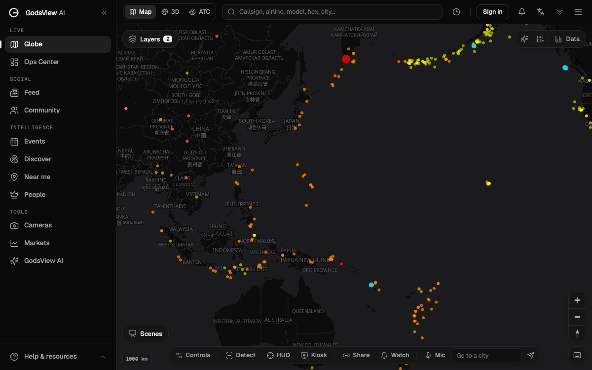
- The circum-Pacific belt, or Ring of Fire. It runs along the rim of the Pacific Ocean, from Chile and the US West Coast to Alaska, Japan, the Philippines, Indonesia and New Zealand. About 81% of the planet's largest earthquakes happen here.
- The Alpide belt. It stretches from Java and Sumatra through the Himalayas and Iran to Turkey and the Mediterranean. It accounts for about 17% of the largest earthquakes.
- The Mid-Atlantic Ridge. Here plates spread apart under the Atlantic. Most of its quakes are far from people, except in Iceland, which sits on top of the ridge.
Earthquakes also happen inside plates, far from any boundary. The 1811 and 1812 New Madrid earthquakes in the central United States are the best-known case. They are rarer, but because the old, cold crust there carries seismic waves efficiently, they can be felt over very large areas.
Some quakes are caused by people. Injecting wastewater deep underground, filling large reservoirs, mining and geothermal projects can all trigger slip on nearby faults. Oklahoma's sharp rise in earthquakes in the 2010s was linked to wastewater disposal from oil and gas production.
You can see the pattern for yourself: open the live earthquake map and the dots line up along the plate edges within a few days of data.
How earthquakes are measured: seismometers, magnitude and intensity
Seismometers record ground motion. A modern instrument measures tiny movements in three directions, and networks of them, linked in real time, let agencies locate a quake from the arrival times of its waves at different stations. The fast P waves (primary, compressional) arrive first; the slower, more damaging S waves (secondary, shearing) and surface waves follow. The gap between them tells a station how far away the quake was.
The USGS National Earthquake Information Center locates about 20,000 earthquakes around the world each year, roughly 55 a day. Many more are too small to be recorded globally.
Magnitude: the size of the earthquake
Magnitude is one number for the whole earthquake. Charles Richter introduced his scale in 1935 for southern California, and the name stuck in everyday speech, but scientists now use the moment magnitude scale (Mw) for anything significant. It's calculated from the fault area that slipped, how far it slipped and the stiffness of the rock, so it doesn't saturate for very large quakes the way older scales did.
The scale is logarithmic. According to the USGS, each whole-number step means about 10 times more ground motion on a seismogram and about 32 times more energy released.
| Step | Ground motion amplitude | Energy released |
|---|---|---|
| M5 to M6 | About 10 times larger | About 32 times more |
| M5 to M7 | About 100 times larger | About 1,000 times more |
| M5 to M8 | About 1,000 times larger | About 32,000 times more |
So an M7 is not "a bit bigger" than an M6. It releases roughly as much energy as 32 M6 quakes.
Intensity: the shaking where you are
Intensity describes the effects at a particular place. The US uses the Modified Mercalli Intensity scale, written in Roman numerals: I is not felt, IV is felt indoors by many, VI is felt by everyone with some damage, and VIII and above means considerable damage to ordinary buildings. One earthquake has one magnitude but many intensities, falling off with distance and varying with soil. Soft, wet ground and basins filled with sediment shake harder than solid rock.
The USGS builds intensity maps partly from people. Its Did You Feel It? survey collects reports from the public and turns them into a map of how strong the shaking was, place by place. GodsView shows those report counts on its city pages; the earthquakes near Los Angeles page, for example, has a "Was it felt" section.
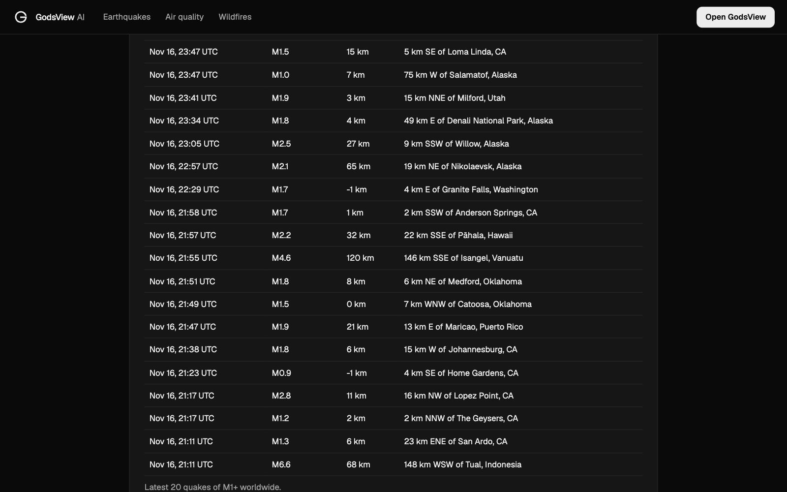
If you felt something and want to know whether it was a quake, our guide to was that an earthquake just now explains how to check within a few minutes.
Can earthquakes be predicted?
No. The USGS is direct about it: "Neither the USGS nor any other scientists have ever predicted a major earthquake" (USGS). A real prediction would need three things: the date and time, the location, and the magnitude. Claims that circulate online usually leave one of those out or are so vague that some earthquake somewhere will always fit.
The reason is that faults are messy. Scientists can measure strain building up, but they can't yet measure the exact friction on a fault kilometres underground, or know which small slip will grow into a big rupture. Animal behaviour, weather, the Moon and "earthquake weather" have all been tested and none works as a predictor.
What does exist is more useful than it sounds.
Long-term forecasts
Forecasts give the probability of a quake in an area over years or decades, the way climate statistics tell you how likely a hot summer is. The Uniform California Earthquake Rupture Forecast (UCERF3), for example, put the chance of at least one magnitude 6.7 or larger quake in the next 30 years at 60% for the Los Angeles region and 72% for the San Francisco Bay Area (USGS). Building codes and insurance are based on numbers like these.
Aftershock forecasts
After a large quake, aftershocks are certain; the question is how many and how big. They follow well-studied statistical patterns, so the USGS publishes aftershock forecasts after significant US earthquakes, giving the chance of further quakes above set magnitudes over the next day, week, month and year. Occasionally the first quake turns out to be a foreshock of a bigger one, and the forecasts include that chance too.
Early warning: ShakeAlert
Early warning doesn't predict anything. It detects a quake that has already started and races the shaking. Because alerts travel at the speed of light and seismic waves travel at a few kilometres per second, people some distance away can get a few seconds to tens of seconds of notice. That's enough to drop, cover and hold on, slow trains or open fire station doors.
In the US, the ShakeAlert system run by the USGS with state partners sends public alerts in California (since 2019), Oregon (since March 2021) and Washington (since May 2021). Alerts reach phones through Wireless Emergency Alerts, Android's operating system and authorised apps. People very close to the epicenter may get the alert after the shaking starts, because there is no time to beat it. Japan, Mexico and several other countries run their own systems. Our roundup of the best earthquake alert apps covers which ones deliver these warnings.
How to follow earthquakes live
For a quick look at what's happening now:
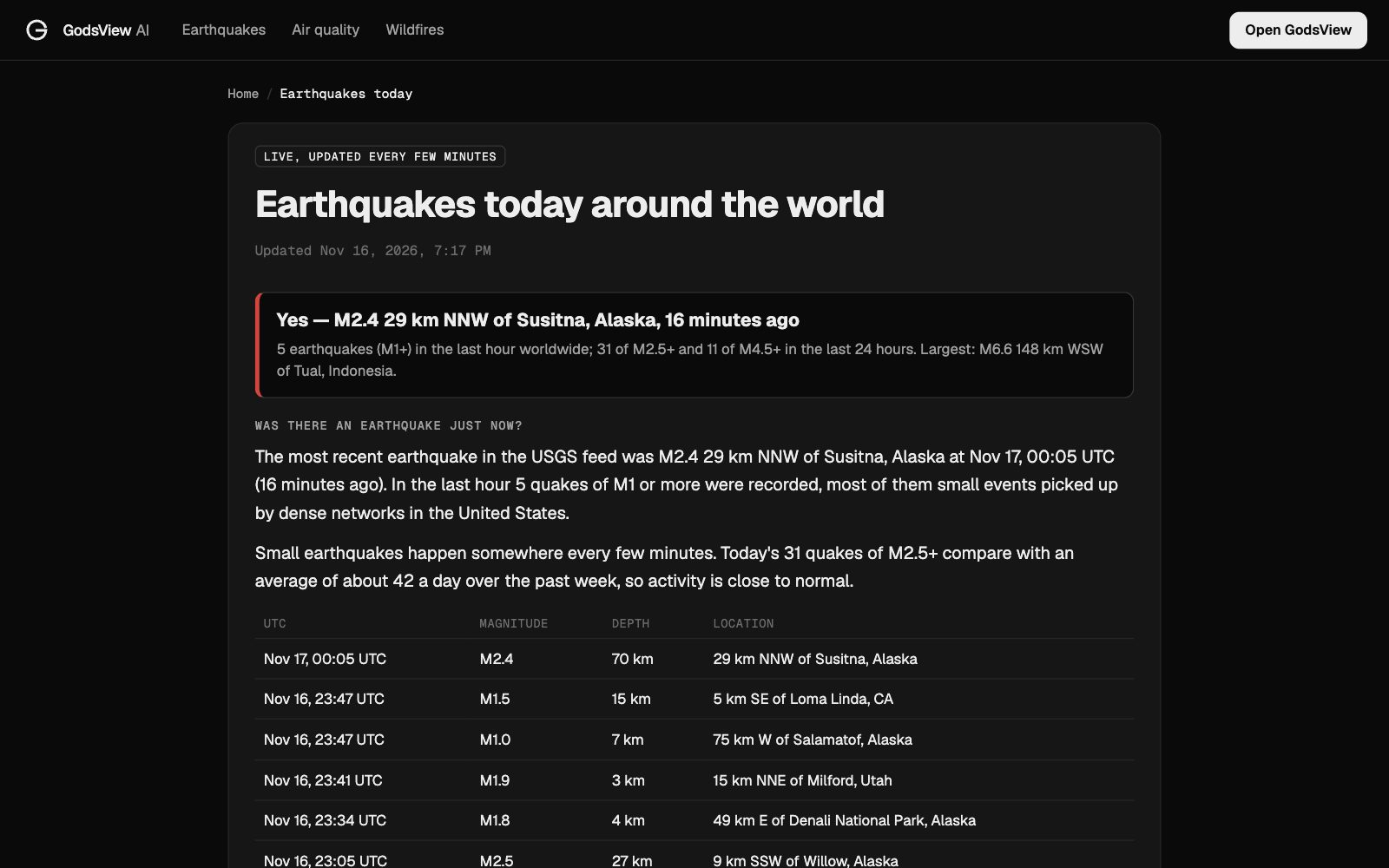
- Today's quakes worldwide. The GodsView earthquakes today page lists the latest events from the USGS feed. On November 16, 2026 it showed 31 earthquakes of M2.5 or more and 11 of M4.5 or more in the previous 24 hours, the largest an M6.6 west-southwest of Tual, Indonesia.
- Near a city. City pages such as earthquakes near Los Angeles show nearby quakes and felt reports.
- On a map. Earthquakes are a free layer on the GodsView live map, next to fires, volcanoes and weather.
- Official sources. The USGS Earthquake Hazards Program has the authoritative event pages, and national agencies such as Japan's JMA cover their own regions.
If you're comparing tools, see our list of the best earthquake tracker websites. GodsView can also send alerts for quakes near places you save, which needs a Plus or Pro plan.
What to do when the ground shakes
Knowing why earthquakes happen doesn't stop them, but a few habits make a real difference where they're common:
- Drop, cover and hold on. Get down, get under a sturdy table, and hold on until the shaking stops. Don't run outside during shaking; falling glass and masonry injure many people.
- Secure heavy things. Bookcases, water heaters and televisions cause many injuries and much of the damage.
- Expect aftershocks. Strong aftershocks can arrive minutes to days later and bring down already damaged structures.
- On the coast, move to high ground if the shaking is strong or long, or if officials issue a tsunami warning. Don't wait to see the water.
Frequently asked questions
Why do earthquakes happen?
Tectonic plates move slowly but stay locked together along faults. Strain builds in the rock until it overcomes friction, and the fault slips suddenly, releasing energy as seismic waves.
Where do most earthquakes occur?
Along plate boundaries. The Pacific Ring of Fire produces about 81% of the world's largest earthquakes and the Alpide belt, from Indonesia through the Himalayas to the Mediterranean, about 17%. You can watch them on the live earthquake map.
How are earthquakes measured?
Seismometers record ground motion. Magnitude, usually moment magnitude, gives the size of the quake, and each whole step releases about 32 times more energy. Intensity, on the Modified Mercalli scale, describes shaking at a particular place.
Can earthquakes be predicted?
No. No scientist has predicted a major earthquake with a time, place and magnitude. Scientists do publish long-term probabilities, aftershock forecasts, and early warnings that go out seconds after a quake begins.
What is the difference between magnitude and intensity?
Magnitude is one number for the whole earthquake. Intensity varies from place to place depending on distance, depth and ground conditions, so one quake has many intensities.
Why are deep earthquakes felt less strongly?
The energy has farther to travel before it reaches the surface, so shaking is weaker near the epicenter but can be felt over a wider area.
What causes aftershocks?
A large quake changes the stress on the surrounding rock and nearby faults, which then adjust with smaller slips. Aftershocks become less frequent over time but can continue for months or years.
Sources
- USGS: Where do earthquakes occur?
- USGS: Earthquake magnitude, energy release, and shaking intensity
- USGS: Can you predict earthquakes?
- USGS: Probability of an earthquake in the Los Angeles and San Francisco Bay areas
- USGS: Determining the depth of an earthquake
- ShakeAlert earthquake early warning
Facts checked on against each provider's own site.