Guide
Earthquake Near Me Today? See the Latest Quakes Around You
You heard about a quake, or a news alert says one hit "near" your city. Here is how to pull up the list of every earthquake around you today, read it in your own time zone, and tell which ones you could have felt.
Key takeaways
- The fastest way to see recent earthquakes near you is a city page that filters the USGS catalogue by distance, such as GodsView's earthquakes near your city pages, which list every M2.5+ quake within 100 km today, this week and this month.
- USGS posts a California quake in about 2.5 minutes on average, a quake elsewhere in the US within about 8 minutes, and a quake outside the US in about 20 minutes.
- National agencies such as PMD in Pakistan, NCS in India and PHIVOLCS in the Philippines often post small local quakes that global catalogues miss, and their magnitudes can differ by a few tenths.
- Earthquake lists are usually in UTC. A quake at 23:30 UTC on one date is already the next morning in Pakistan, India, the Philippines or Timor-Leste.
- As a rough rule, an M3 is felt within a few tens of kilometres, an M5 out to a couple of hundred, and an M6 or larger up to several hundred kilometres away.
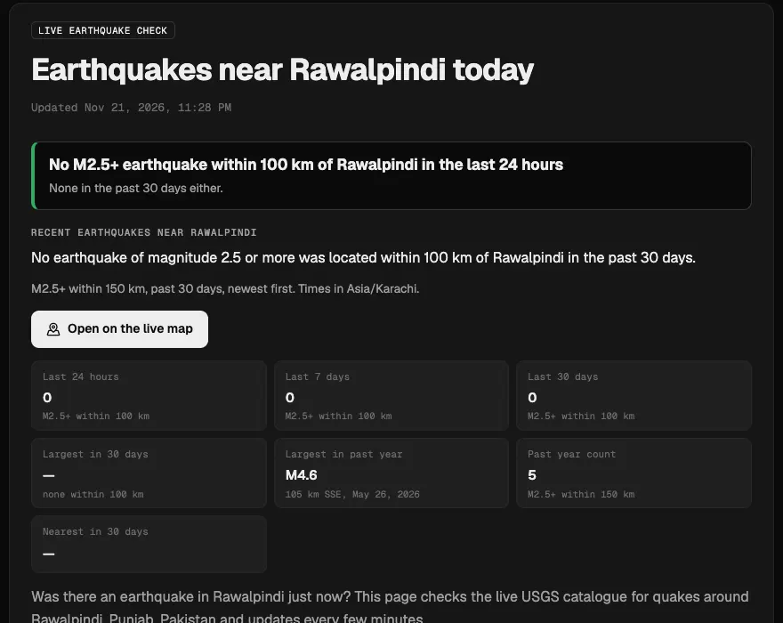
To check whether there was an earthquake near you today, open a list of recent quakes filtered by distance from your city. On GodsView, earthquakes near me finds your nearest city page, and each page, such as earthquakes near Rawalpindi, shows every M2.5+ quake within 100 km in the last 24 hours, 7 days and 30 days from the USGS catalogue, in local time. For the whole planet, earthquakes today lists the latest quakes worldwide, refreshed every few minutes.
This guide covers where those numbers come from, which agency to check for your country, why a quake you heard about may be missing, how far shaking really travels, and how to read the times. If you felt shaking a moment ago and want a quick yes or no, our guide was that an earthquake just now? is the shorter read.
Find earthquakes near your city
The quick answer: three places to look
| What you want to know | Where to look | How fast |
|---|---|---|
| Any quake near my city today, this week, this month | GodsView city page, e.g. /earthquakes/near/des-moines-wa | Refreshed every few minutes from USGS |
| The latest quakes anywhere in the world right now | GodsView earthquakes today, USGS Latest Earthquakes, EMSC | USGS: 2.5 to 20 minutes after the quake |
| Small local quakes the global lists miss | Your national seismic agency (PMD, NCS, PHIVOLCS, BMKG, JMA, GeoNet) | Varies, often within minutes for felt quakes |
| Did other people feel it? | EMSC LastQuake felt reports, USGS "Did You Feel It?" | Felt quakes usually spotted within 2 minutes |
How to see every earthquake near you today
- Go to earthquakes near me and tap Use my location, or pick your city from the list. Your browser asks for permission; the location is used to find the nearest city page.
- Read the answer box at the top. It says either that an M2.5+ quake hit within 100 km in the last 24 hours, with its distance and direction from the city, or that there was none.
- Check the counts for the last 24 hours, 7 days and 30 days, and the largest quake within 150 km in the past year. A single quiet day means little in an active region; the yearly count tells you how often quakes really happen near you.
- Scroll to the table of recent quakes. Each row has the local time, magnitude, depth and distance, and links to the full event page.
- Open the quake on the live map to see where it sits relative to faults, towns and other recent shocks.
City pages exist for thousands of cities, including the ones people search for most after a felt quake: Rawalpindi, Peshawar, Dili, Pasay, Des Moines, Washington, Mohali and Dehradun. For a whole country, use pages such as earthquakes in Pakistan or earthquakes in the Philippines.
Earthquakes today around the world
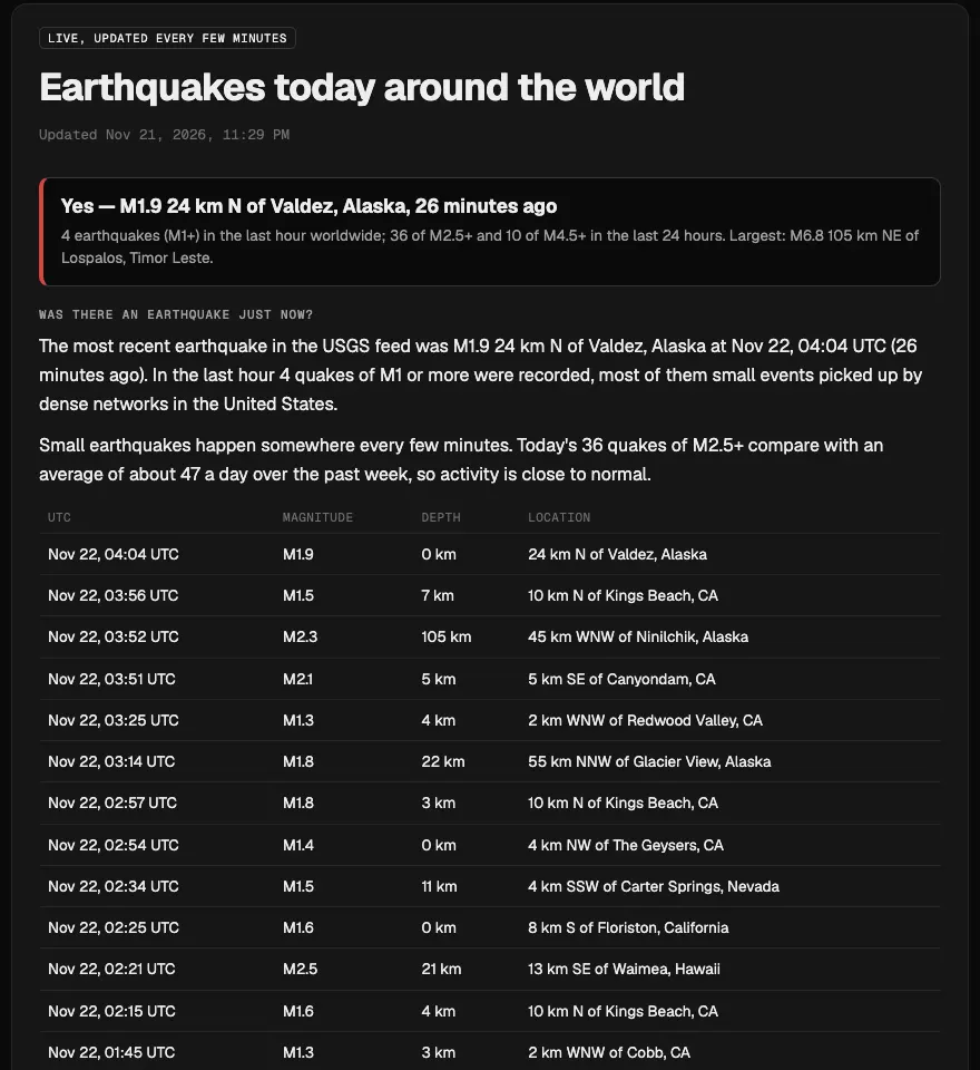
Sometimes the question is not about your street but about the news: "there was an earthquake today, where was it?" The earthquakes today page answers that. It shows the most recent quake in the USGS feed, how many M2.5+ and M4.5+ quakes happened in the last 24 hours, the largest of the day, and a table of the latest events in UTC.
On November 21, 2026, for example, the page listed 36 quakes of M2.5 or more in the previous 24 hours against a recent average of about 47 a day, with the largest an M6.8 about 105 km northeast of Lospalos, Timor-Leste. A quake that size in the Banda Sea region is why people in Dili search for "earthquake Dili today" within minutes.
To see the same quakes in context, open the Earthquakes layer on the live globe, a god's eye view of the world, live, where each quake is drawn at its epicentre and sized by magnitude. You can turn on flights, ships and fires on the same map. The globe needs a free account; the earthquake pages above do not.
Which agency posts first, and why lists disagree
Several organisations locate earthquakes, and their lists rarely match exactly.
USGS, the global baseline
The US Geological Survey's National Earthquake Information Center locates quakes worldwide. According to USGS, a quake in California is processed and posted in about 2.5 minutes on average, one elsewhere in the United States within about 8 minutes, and one outside the US in about 20 minutes. USGS lists quakes of every size inside the US, but outside it the list is only complete from roughly magnitude 4 to 4.5. That is why a small quake that rattled windows in Rawalpindi or Dehradun can be missing from USGS while the national agency has it.
EMSC and LastQuake
The European-Mediterranean Seismological Centre (EMSC) gathers data from many networks and runs LastQuake, which detects felt quakes from surges in website traffic and social posts. EMSC says felt quakes are generally detected in less than two minutes, and people who felt them can file reports in the LastQuake app. It is a good second check, especially in Europe, the Mediterranean, the Middle East and South Asia.
National agencies
For small local quakes, your own country's agency usually has the most complete list:
- Pakistan: the Pakistan Meteorological Department's seismic monitoring site lists quakes with UTC time, magnitude and depth.
- India: the National Center for Seismology runs a network of more than 170 stations and posts recent quakes on seismo.gov.in.
- Philippines: PHIVOLCS posts earthquake information for the Philippines, including Metro Manila and Pasay.
- Indonesia and the Timor region: BMKG reports quakes across Indonesia and its neighbouring seas.
- Japan: the Japan Meteorological Agency issues intensity reports, and New Zealand: GeoNet.
- US Pacific Northwest: the Pacific Northwest Seismic Network covers Washington and Oregon, including the Seattle area and Des Moines, WA, alongside USGS.
Why the magnitude changes
The first number is automatic. Over the next minutes to hours, analysts review it, and different agencies use different magnitude types and station sets, so an M4.9 from one can be an M5.2 from another. Locations shift too, by a few kilometres or more for remote quakes. When you compare lists, match quakes by time first, then by place, rather than by magnitude. Our guide on how to read an earthquake map explains magnitude types and reviewed versus automatic events.
How far away can you feel an earthquake?
Whether a quake "near me" mattered depends on its size, depth and the ground under you. GodsView's city pages use a simple rule of thumb, labelled as such on the page:
| Magnitude | Roughly felt within | What people usually notice |
|---|---|---|
| Below M3 | About 15 km | Rarely felt, except right above it |
| M3 to M3.9 | About 40 km | A jolt or rumble, like a passing truck |
| M4 to M4.9 | About 100 km | Rattling windows and dishes near the epicentre |
| M5 to M5.9 | About 250 km | Widely felt; damage possible near the epicentre |
| M6 and above | About 500 km or more | Felt across a region; damage likely near the source |
Deep quakes are felt over a wider area but less sharply. The Hindu Kush region of Afghanistan, for example, produces quakes about 200 km deep that are felt in Islamabad, Rawalpindi, Peshawar and northern India. Soft basins, such as parts of Mexico City or reclaimed land around Manila Bay, can amplify shaking far from the epicentre. Tall buildings sway at the long periods that travel farthest, so people on upper floors often notice a distant quake that people outside do not.
Reading the time: UTC, local time and "today"
Global catalogues use Coordinated Universal Time (UTC). "Today" in UTC is not today where you live:
| Place | Offset from UTC (November) | A quake at 23:30 UTC on Nov 21 is |
|---|---|---|
| Pakistan (PKT) | +5 | 04:30 on Nov 22 |
| India (IST) | +5:30 | 05:00 on Nov 22 |
| Philippines (PHT) | +8 | 07:30 on Nov 22 |
| Timor-Leste | +9 | 08:30 on Nov 22 |
| Washington State (PST) | -8 | 15:30 on Nov 21 |
GodsView's city pages show local time and UTC side by side, so you do not have to convert. When you share a quake with family or on social media, give both, or link the event page, which never changes.
Why a quake you heard about isn't on the list
- It was too small for the global catalogue. Outside the US, USGS is only complete from about M4. Check your national agency.
- It is still being processed. Give it up to 20 minutes for a quake outside the US.
- It was farther away than you think. City pages count quakes within 100 km. A news alert that says "near Islamabad" may mean a quake 250 km away in the Hindu Kush, which appears on the Pakistan country page and the world list instead.
- It was not an earthquake. Sonic booms, quarry blasts, thunder and heavy trucks are often mistaken for quakes. Our guide to loud booms covers how to tell them apart.
- It was a rumour. Posts that predict a quake "tonight" are not based on science; no agency can predict earthquakes.
Get told next time instead of searching
Searching after the fact works, but an alert is faster. On GodsView Plus ($10.99 a month or $99.99 a year) you can save your home or a family member's town in My places and get an alert by app, browser push or email when an earthquake of M4.5 or more strikes nearby, along with storms, fires and bad air. The disaster alerts guide shows the setup.
Alerts like these arrive after a quake is located; they are not early warnings. For warnings seconds before shaking, see our comparison of earthquake alert apps, which covers ShakeAlert, Android's system and Japan's JMA warnings.
See today's earthquakes worldwide
What to do after a quake near you
If you felt strong shaking, expect aftershocks, check your home for gas leaks and cracks, and follow your local disaster authority. Near a coast, a long or strong quake is itself a natural tsunami warning: move to high ground without waiting for an official message. Our guide on what a tsunami is explains warnings and advisories.
For a small quake you barely noticed, there is usually nothing to do except report it. Felt reports to USGS "Did You Feel It?" or EMSC LastQuake help scientists map shaking and improve future estimates.
Frequently asked questions
Was there an earthquake near me today?
Open earthquakes near me and use your location or pick your city. The page says whether an M2.5+ quake happened within 100 km in the last 24 hours and lists the most recent ones with their distance, depth and local time.
Where can I see earthquakes that happened today worldwide?
The earthquakes today page lists the latest quakes in the USGS feed, the 24-hour counts of M2.5+ and M4.5+ events and the largest of the day. The USGS Latest Earthquakes map and EMSC show the same events with their own processing.
How soon after an earthquake does it appear online?
USGS says a California quake is posted in about 2.5 minutes on average, one elsewhere in the US within about 8 minutes, and one outside the US in about 20 minutes. EMSC usually detects felt quakes within 2 minutes from crowd reports.
Why does my country report a different magnitude than USGS?
Agencies use different stations and magnitude types, and early numbers are automatic. Differences of a few tenths are normal, and figures are often revised in the first hours.
Why is a small earthquake missing from the map?
Outside the United States the USGS catalogue is only complete from about magnitude 4 to 4.5, so smaller local quakes may appear only on your national agency's list, such as PMD in Pakistan, NCS in India or PHIVOLCS in the Philippines.
Can I get an alert when an earthquake hits near my home?
Yes. With GodsView Plus you can save places in My places and get app, push or email alerts for M4.5+ quakes nearby. These alerts follow the official location; they are not early warnings before shaking.
Sources
- USGS — How quickly is earthquake information posted to the USGS website?
- USGS — Why is an earthquake I felt not on the Latest Earthquakes map?
- EMSC — The LastQuake system
- National Center for Seismology, India
- Pakistan Meteorological Department — seismic monitoring
- USGS Earthquake Hazards Program — real-time feeds
Facts checked on against each provider's own site.