Storms
When Is Hurricane Season? Dates for Every Ocean, and Is It Over?
Hurricane season is not one set of dates. Each ocean has its own, a few have none at all, and storms ignore the calendar anyway. Here are the official seasons, when each one peaks, how the 2026 Atlantic season went, and how to check what is heading your way today.
Key takeaways
- The Atlantic hurricane season runs from June 1 to November 30. The eastern North Pacific season runs from May 15 to November 30, and the central Pacific season around Hawaiʻi from June 1 to November 30.
- The Atlantic peaks on September 10, with most activity between mid-August and mid-October, according to the National Hurricane Center.
- The western North Pacific has no official typhoon season: storms form in every month, with the main season July to November and a peak in late August and early September.
- In the Southern Hemisphere the season runs roughly November to April. Australia's official season is November 1 to April 30.
- As of November 16, 2026, NHC counted 10 named storms in the Atlantic, one of them a hurricane (Isaias, a major hurricane in October), and total storm energy 83% below normal.
- Storms can form outside the official dates. To see what is coming now, check NHC's Tropical Weather Outlook and a live map of storm tracks.
The Atlantic hurricane season runs from June 1 to November 30 each year, with a peak around September 10. The eastern Pacific season starts earlier, on May 15, and also ends November 30; the western Pacific has typhoons all year; and in the Southern Hemisphere the cyclone season runs roughly November to April. So on November 16, 2026, the Atlantic season is in its last two weeks, and the Australian and South Pacific seasons have just begun.
If you are asking because a storm is in the news, jump to the section on what hurricane is coming right now, or open the live hurricane tracker. The rest of this guide covers the dates for every ocean, why the peak falls when it does, how names and categories work, and what the end of the season really means.
See active storms on the live map
Hurricane season dates for every ocean
Hurricanes, typhoons and cyclones are the same kind of storm: a tropical cyclone. The name changes with the ocean, and so does the season. The table below gives the official or typical season for each basin, and when activity usually peaks.
| Ocean basin | Season | Usual peak | Official forecast centre |
|---|---|---|---|
| North Atlantic, Caribbean, Gulf of America | June 1 to November 30 | September 10; most storms mid-August to mid-October | National Hurricane Center (Miami) |
| Eastern North Pacific (Mexico to 140°W) | May 15 to November 30 | Late August; most storms late June to early October | National Hurricane Center (Miami) |
| Central North Pacific (around Hawaiʻi) | June 1 to November 30 | July to September | Central Pacific Hurricane Center (Honolulu) |
| Western North Pacific (typhoons) | No official season; storms in every month | Main season July to November, peak late August and early September | Japan Meteorological Agency (Tokyo) |
| North Indian Ocean (Bay of Bengal, Arabian Sea) | April to December | Two peaks, May and November | India Meteorological Department (New Delhi) |
| Australia and the Southwest Pacific | November 1 to April 30 in Australia | Late February and early March | Bureau of Meteorology, Fiji Meteorological Service and others |
| Southwest Indian Ocean (Madagascar, Mauritius, Réunion) | Roughly November to April | Southern summer | Météo-France (La Réunion) |
The Atlantic and eastern Pacific dates come from NHC's climatology pages (NHC). The western Pacific, North Indian and Australian patterns are from NOAA's Hurricane Research Division FAQ (NOAA AOML), and the Australian dates from the Bureau of Meteorology. NOAA's FAQ also notes that, worldwide, September is the most active month and May the least active.
The North Indian Ocean is the odd one out. Its two peaks sit either side of the summer monsoon, when strong winds high in the atmosphere tear developing storms apart. That is why the Bay of Bengal is busy right now: in the first half of November 2026, the Global Disaster Alert and Coordination System (GDACS) listed two tropical cyclones there, Murasu from November 1 to 3 and Akvan, active on November 16.
For who forecasts each ocean and why their numbers can disagree, see our worldwide storm tracker guide.
Why the Atlantic peaks in September
Tropical cyclones need warm ocean water, roughly 26.5°C (80°F) or warmer, moist air and light winds high up. In the Atlantic, the sea keeps warming all summer and is warmest in late August and September. That is also when the tropical waves rolling off West Africa are most frequent and the upper-level winds are often calmest.
NHC puts the peak of the Atlantic season on September 10, "with most activity occurring between mid-August and mid-October" (NHC). Its tables show how the average season builds. Based on 1991 to 2020:
- The first named storm typically forms around June 20.
- The first hurricane forms around August 11.
- The first major hurricane (Category 3 or stronger) forms around September 1.
- The 14th named storm, the seasonal average, does not arrive until about November 19.
An average Atlantic season has 14 named storms, 7 hurricanes and 3 major hurricanes. The eastern Pacific averages 15 named storms, 8 hurricanes and 4 major hurricanes, and its peak is less pronounced, spread over a longer stretch of summer.
June storms tend to form close to home, in the Gulf or the western Caribbean, and are often weak and fast. The long-track Cape Verde hurricanes that cross the whole Atlantic are a feature of August and September.
Is hurricane season over?
Not officially until November 30 in the Atlantic and the Pacific basins NHC and CPHC cover. In practice, storms in late November are uncommon, and when they do form they are usually in the Caribbean or the open Atlantic, rather than threatening the US Gulf Coast.
The end date is a convention, not a rule of nature. Storms do form outside it. Hurricane Alex formed in the Atlantic in January 2016, and a run of recent seasons had a named storm before June 1. NHC's naming rules cover this: a storm in December takes the next name from that year's list, and one in February takes a name from the coming year's list (NHC).
After November 30, NHC stops its routine Tropical Weather Outlooks for the Atlantic and eastern Pacific until the next season, but keeps watching, and it issues special outlooks and advisories if anything develops.
And if you live somewhere else, "is hurricane season over?" has a different answer:
- Australia, the South Pacific and the southwest Indian Ocean: the season is just starting in November and runs into April.
- The Bay of Bengal and Arabian Sea: November is one of the two peak months.
- The western Pacific: typhoons can form in any month, including December and January, though fewer do.
The 2026 Atlantic hurricane season so far
The 2026 Atlantic season has been very quiet. NHC's season summary, last updated November 16, 2026, lists 10 named storms, one hurricane and one major hurricane. Its total Accumulated Cyclone Energy (ACE), a measure that combines how strong storms were and how long they lasted, was 19.9, which NHC puts at 83% below the 1991 to 2020 normal (NHC 2026 season summary).
| Storm | Type at peak | Dates (UTC) | Peak wind |
|---|---|---|---|
| Arthur | Tropical storm | June 17 to 18 | 50 kt (about 60 mph) |
| Bertha | Tropical storm | July 19 to 23 | 50 kt |
| Cristobal | Tropical storm | August 12 to 13 | 40 kt |
| Dolly | Tropical storm | August 27 to 28 | 35 kt |
| Edouard | Tropical storm | August 31 to September 2 | 50 kt |
| Fay | Tropical storm | September 19 to 29 | 60 kt |
| Gonzalo | Tropical storm | September 25 to 26 | 45 kt |
| Hanna | Tropical storm | September 28 to 30 | 40 kt |
| Isaias | Major hurricane | October 6 to 10 | 105 kt (about 120 mph, Category 3) |
| Josephine | Subtropical storm | October 21 to 22 | 55 kt |
Isaias was the season's only hurricane, and it did not become one until October. NOAA had expected a quiet year: its August 6, 2026 update predicted a below-normal season with 7 to 13 named storms, 2 to 6 hurricanes and 0 to 2 major hurricanes, and pointed to El Niño, which tends to increase wind shear over the tropical Atlantic and suppress storms (NOAA).
A quiet season is not a safe one for everyone. NHC's table lists one direct death and about $1.1 billion in US damage for 2026, all of it from Tropical Storms Arthur and Bertha. A storm does not need to be a hurricane to do harm.
Meanwhile NOAA's outlook for the central Pacific around Hawaiʻi went the other way, calling for an above-normal season with 5 to 13 tropical cyclones; El Niño years tend to favour storms there.
How hurricanes are named, and why names are retired
Storms get a name once they reach tropical storm strength, sustained winds of 39 mph (34 knots) or more. Names make warnings easier to follow than numbers or coordinates.
In the Atlantic, six lists of 21 names are used in rotation, so the 2026 list (Arthur, Bertha, Cristobal and so on) will be used again in 2032. The lists skip Q, U, X, Y and Z. If a season runs out of names, NHC uses a supplemental list kept by the World Meteorological Organization. The eastern Pacific has its own six lists, the central Pacific uses Hawaiian names taken in order, and other oceans use lists set by their own WMO regional committees (NHC).
A name is retired when a storm is so deadly or costly that using it again would be insensitive. A WMO committee strikes it from the list and picks a replacement at its annual meeting. In March 2026 the committee retired Melissa, after the 2025 hurricane that devastated Jamaica, and replaced it with Molly. WMO said Melissa was the 100th name retired in the Atlantic basin (WMO).
Hurricane categories: the Saffir-Simpson scale
In the Atlantic and the eastern and central Pacific, hurricane strength is rated on the Saffir-Simpson Hurricane Wind Scale, based on one-minute maximum sustained wind (NHC):
| Category | Sustained wind | Typical damage |
|---|---|---|
| Tropical depression | 38 mph or less | Heavy rain, little wind damage |
| Tropical storm | 39 to 73 mph | Downed branches, power cuts, flooding rain |
| Category 1 | 74 to 95 mph | Some damage to roofs, siding and trees; power outages likely |
| Category 2 | 96 to 110 mph | Extensive damage; near-total power loss for days to weeks |
| Category 3 (major) | 111 to 129 mph | Devastating damage; electricity and water out for days to weeks |
| Category 4 (major) | 130 to 156 mph | Catastrophic damage; areas uninhabitable for weeks or months |
| Category 5 (major) | 157 mph or higher | Catastrophic damage; a high share of homes destroyed |
The scale only measures wind. NHC is clear that storm surge, rainfall flooding and tornadoes can be deadly in any category, and water, not wind, causes most hurricane deaths. A slow Category 1 or a tropical storm can flood a city.
Other oceans use other scales. Japan and most Southern Hemisphere centres average wind over ten minutes, so their numbers look lower for the same storm, and Australia's Category 1 to 5 is not the same as Saffir-Simpson's. In the western Pacific, a storm with winds above 150 mph is called a super typhoon.
What hurricane is coming right now?
Three places answer that question.
1. NHC's Tropical Weather Outlook. During the season, NHC publishes outlooks for the Atlantic and eastern Pacific at least every six hours. They mark disturbances that might develop and give the chance of formation in the next 48 hours and 7 days, as low, medium or high. A yellow, orange or red area on that map is a system to watch, not yet a storm. On the afternoon of November 16, 2026, NHC's active storms feed listed no tropical cyclones in the Atlantic, eastern Pacific or central Pacific.
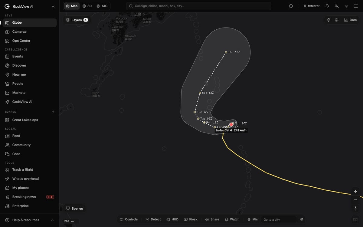
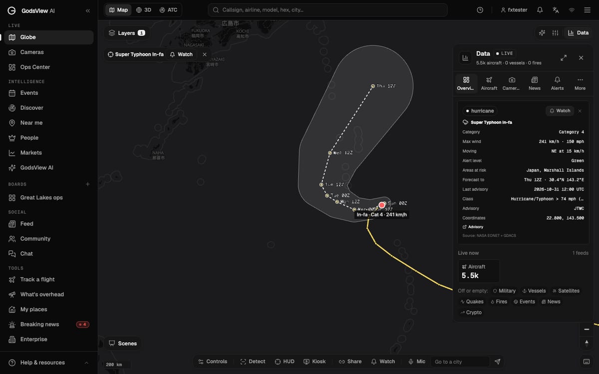
2. A live map of storm tracks. The GodsView hurricane tracker shows active storms on the live globe, with the observed track, the forecast line and the forecast cone, plus weather warnings, nearby flights and storm news in one view. The storm tracks layer draws on GDACS, which republishes official advisories for every ocean, so it shows typhoons and southern cyclones as well as Atlantic hurricanes. Click a storm for its category, wind, movement and areas at risk.
If the list is empty, no storm has a public position right now. Our guide to how to watch a hurricane live explains how to read the cone and why being outside it does not mean you are safe.
3. Your local weather service. NHC forecasts the storm; your local National Weather Service office, or your national weather service outside the US, issues the watches and warnings for your area. A hurricane watch means hurricane conditions are possible, usually within 48 hours; a warning means they are expected, usually within 36 hours. See weather watch vs warning for every alert type, and check weather warnings near you for what is in force now.
You can also open the full live map and switch on the storm, weather and radar layers together, which helps when a storm is near busy airports or shipping lanes.
How to get ready before the season
The time to prepare is before a storm has a name. A short list:
- Know your zone. Find out whether you live in a storm surge evacuation zone. Your county or emergency management office publishes the map.
- Plan for power cuts. Hurricanes are the biggest single cause of long US power outages. Keep a battery or power bank charged, and know how to check outages; our power outage map guide covers utility maps and the GodsView power outages page.
- Set up alerts. Turn on the official emergency alerts on your phone. On GodsView you can save your home on My places or draw a watch area along a coast and switch on tropical cyclone and severe weather alerts; saved watches and alerts need GodsView Plus or Pro. The setup is in how to get disaster alerts near home.
- Do not wait for the category. Evacuation orders are based on surge and flooding, not just wind. Follow them.
Frequently asked questions
When is hurricane season in 2026?
The 2026 Atlantic hurricane season runs from June 1 to November 30, 2026. The eastern Pacific season runs from May 15 to November 30. The dates are the same every year.
Is hurricane season over?
In the Atlantic and eastern Pacific it officially ends on November 30. Late-season and off-season storms are uncommon but possible. In Australia, the South Pacific and the southwest Indian Ocean the season runs roughly November to April.
When is the peak of hurricane season?
In the Atlantic, September 10, with most activity from mid-August to mid-October. The eastern Pacific peaks in late August, and western Pacific typhoons peak in late August and early September.
What hurricane is coming now?
Check the National Hurricane Center's Tropical Weather Outlook for disturbances that may develop, and the GodsView hurricane tracker for active storms worldwide with tracks and forecast cones. Your local weather service issues the warnings for your area.
How active was the 2026 Atlantic hurricane season?
Very quiet. As of November 16, 2026, NHC counted 10 named storms and one hurricane, Isaias, which became a major hurricane in October. Total storm energy was 83% below the 1991 to 2020 normal.
Is there a typhoon season?
Not officially. In the western North Pacific typhoons form in every month. The main season is July to November, and the quietest time is February and the first half of March.
Why are hurricane names retired?
When a storm is so deadly or costly that reusing its name would be insensitive, a WMO committee removes it and picks a replacement. Melissa was retired in March 2026 and replaced with Molly.
Sources
- NOAA National Hurricane Center: Tropical cyclone climatology
- NOAA National Hurricane Center: 2026 Atlantic hurricane season summary
- NOAA: NOAA maintains prediction for below-normal Atlantic hurricane season (August 6, 2026)
- NOAA National Hurricane Center: Tropical cyclone naming
- NOAA National Hurricane Center: Saffir-Simpson Hurricane Wind Scale
- NOAA AOML Hurricane Research Division: Hurricane FAQ
- WMO: Hurricane Committee retires name of Melissa, replaces it with Molly
- GDACS: Global Disaster Alert and Coordination System
Facts checked on against each provider's own site.